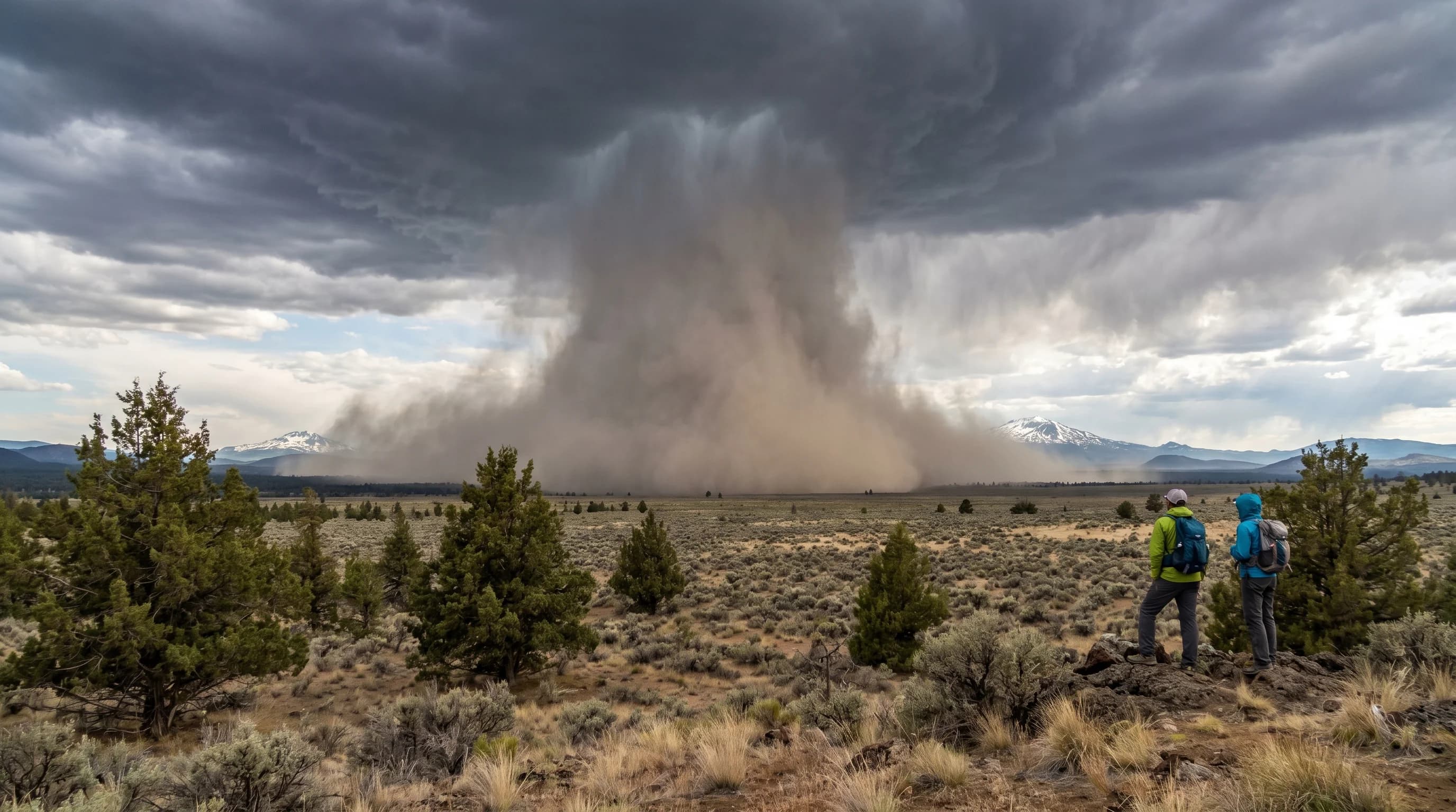
A microburst is a sudden, violent blast of wind that rushes down out of a thunderstorm and slams into the ground, spreading outward at speeds that can rival a tornado. In Central Oregon's high desert, microbursts are an underappreciated summer hazard: they strike with little warning, they can topple trees and capsize boats, and they thrive in exactly the dry conditions the region is known for. Unlike a tornado's rotating column, a microburst is a straight-down, straight-out punch of air, and it is one of the most dangerous things a high-desert thunderstorm can produce.
What Is a Microburst?
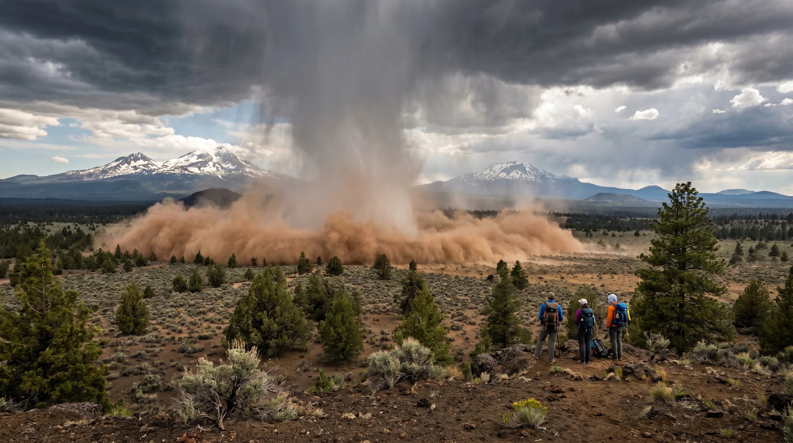
A microburst is a small but intense column of sinking air, a downdraft, that descends rapidly from a thunderstorm and spreads out violently when it hits the ground. The term microburst refers to its compact size, typically less than two and a half miles across, but its winds can exceed 100 miles per hour, comparable to a strong tornado. When the rushing air strikes the surface, it has nowhere to go but outward, blasting horizontally in all directions from the point of impact.
This outward-blasting pattern is the key difference between a microburst and a tornado. A tornado's winds rotate around a center and converge inward; a microburst's winds radiate straight outward from where the downdraft lands. The damage pattern shows it: trees and debris from a microburst fan out away from a central point, rather than the twisted, converging pattern of a tornado. Microbursts are a form of straight-line wind, and they can be just as destructive as the rotating storms that get more attention.
Why the High Desert Favors Dry Microbursts
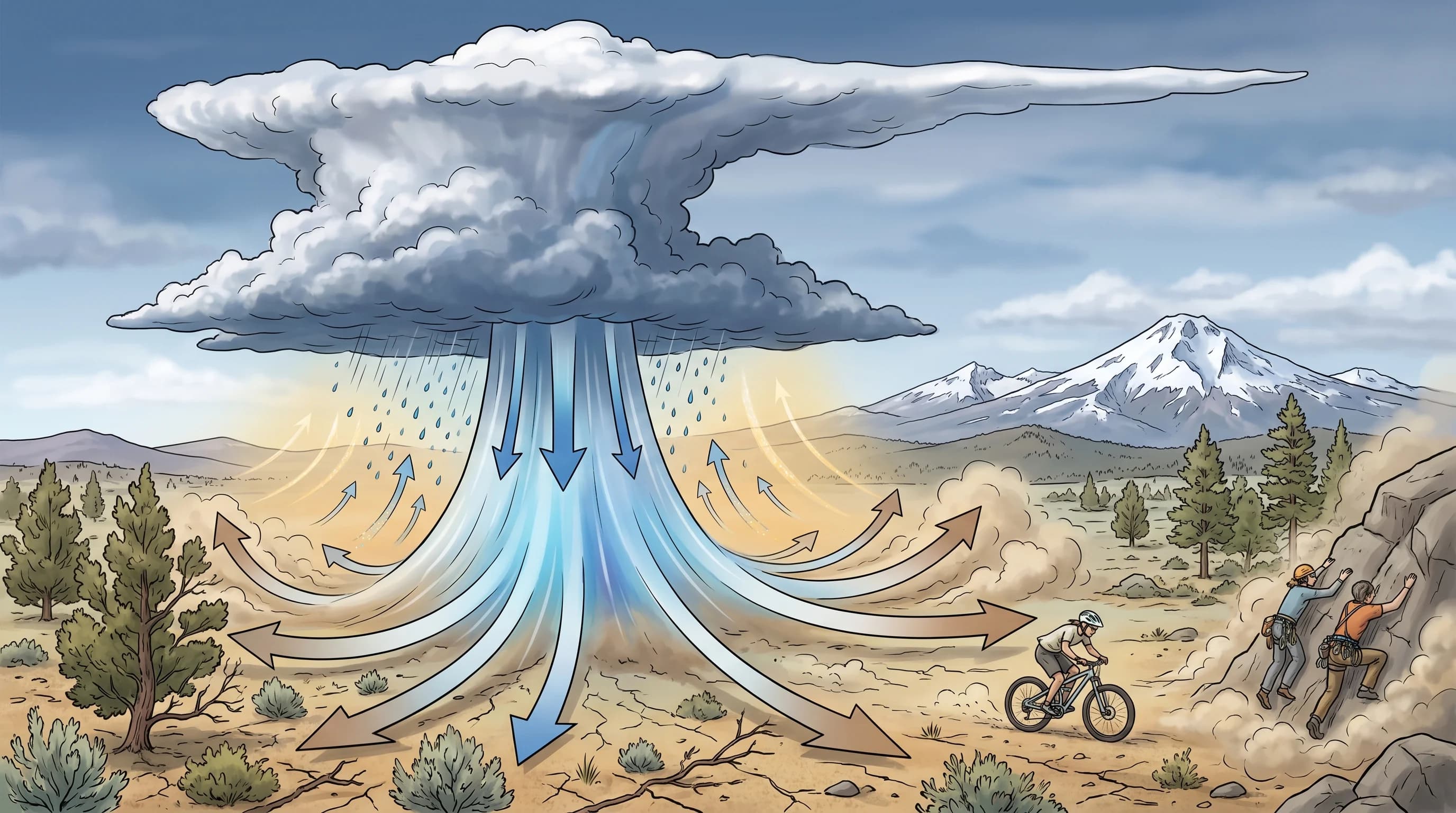
Central Oregon's dry air makes it prone to dry microbursts, in which evaporating rain supercharges the downdraft even though little rain reaches the ground. The mechanism is evaporative cooling: as rain falls from a storm into the deep, dry layer of air below, it evaporates, and evaporation cools the surrounding air. That cooled air is denser than its surroundings, so it accelerates downward, gaining speed as it plunges toward the ground. The drier the air below the storm, the more evaporation and the more powerful the resulting downdraft.
This is why the high desert, with its characteristically dry low-level air, is fertile ground for microbursts, and why so many here are dry microbursts that arrive with dust instead of rain. The same dry air that produces virga and dry thunderstorms drives these events, all part of the family of dry-storm hazards covered in why Central Oregon storms can be dry, windy, and dangerous. A storm that drops barely any rain can still unleash a ground-level wind blast strong enough to cause serious damage.
Why Microbursts Are So Dangerous
Microbursts are dangerous because they strike suddenly, with hurricane-force winds and almost no warning, in places and conditions where people are exposed. On the high desert's lakes and reservoirs, a microburst can turn calm water into dangerous waves in moments, a serious threat to paddlers and boaters who have no time to reach shore. In the forest and on the trail, the winds can snap and topple trees, and across open country they can whip up blinding dust and damage structures.
Microbursts are also a well-known aviation hazard, since the sudden wind shift can rob an aircraft of lift during takeoff or landing, a particular concern around regional airports. For anyone outdoors, the danger is the speed of onset: a microburst goes from nothing to peak winds in minutes and lasts only a short time, so there is little chance to react once it begins. The brief duration is small comfort given how much damage those few minutes can do.
How to Stay Safe From Microbursts
The best protection against microbursts is the same as for any thunderstorm: respect the storm before it arrives, and be off the water and out of exposed areas when storms threaten. Because microbursts come from thunderstorms, the warning signs are the storms themselves, building cumulus, distant thunder, an approaching dark cloud base, and virga streaks hanging beneath a storm, which signal the evaporating rain that can drive a dry microburst. If a storm is near, assume sudden violent wind is possible.
Boaters and paddlers should get off the water at the first sign of an approaching storm, since a microburst can capsize a small craft in seconds. On land, move away from large trees and exposed ridgelines and seek sturdy shelter. The general thunderstorm-safety rules for the region's lakes and high country, covered in lightning safety for hikers and lakes, also protect against microbursts: the same early-out, watch-the-sky discipline that avoids lightning keeps you clear of the wind. Microbursts are a vivid reminder that high-desert thunderstorms are dangerous for their wind as much as their lightning, part of the broader summer-storm picture in the summer thunderstorms guide.