
A heat dome is a strong ridge of high pressure that parks over a region and traps hot air beneath it like a lid, driving extreme heat that can last for days or more than a week. The sinking air under the ridge compresses and warms, the clear skies let the sun bake the ground day after day, and cooler systems are blocked from moving in. The 2021 Pacific Northwest heat dome is the canonical example, pushing Portland to an all-time record of 116 degrees and sending Central Oregon into dangerous, unprecedented heat, a vivid reminder that even mild-summer regions are not immune.
What Is a Heat Dome?

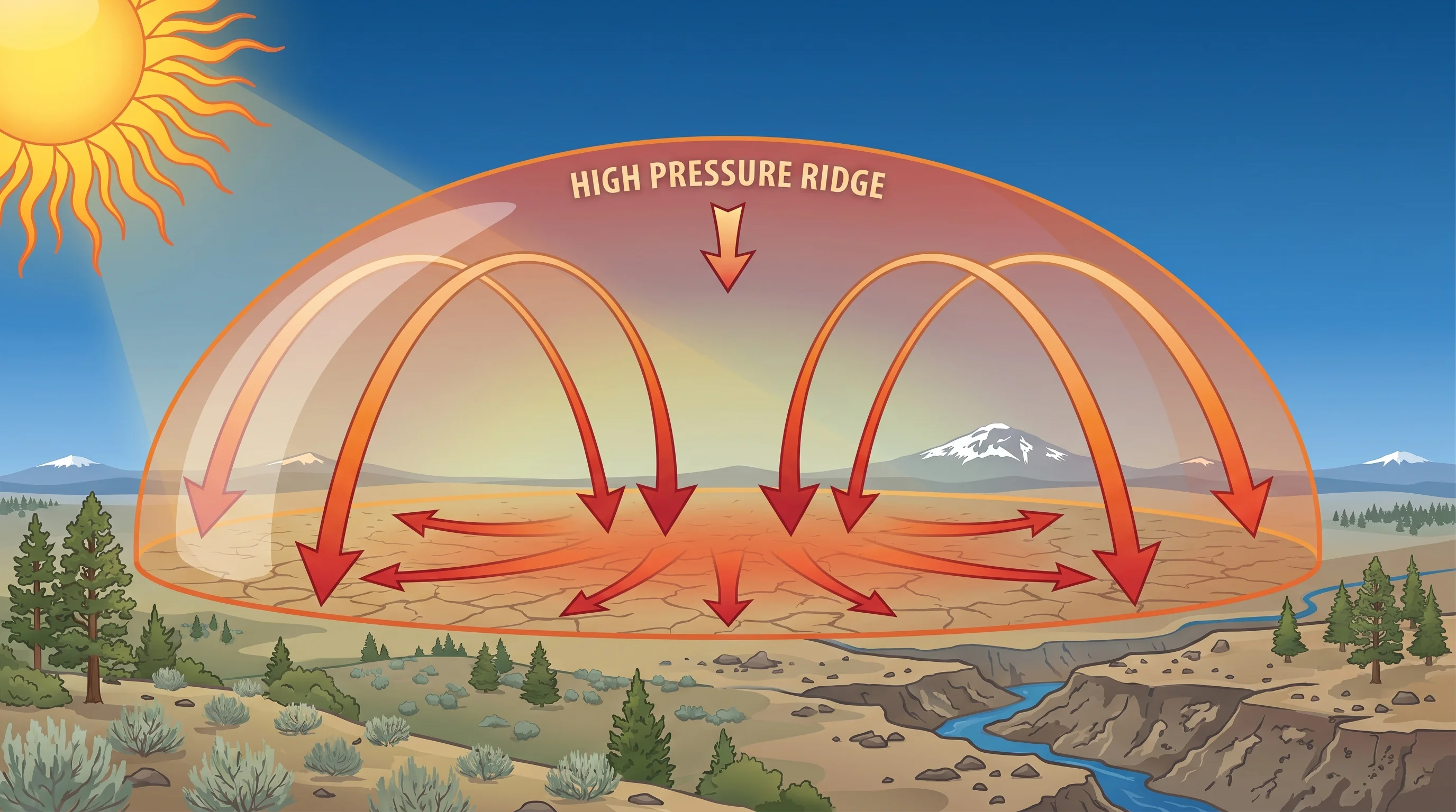
A heat dome is essentially a lid of high pressure in the upper atmosphere that sits in place over a region and concentrates heat beneath it. Under a strong high, air sinks, and as it sinks it compresses and warms, while the high pressure also clears away clouds. With sinking, warming air above and clear skies letting the sun pour in, the ground heats relentlessly, and because the ridge is parked rather than moving through, the heat builds and compounds over consecutive days instead of breaking overnight.
The result is the most severe and persistent kind of heat wave. An ordinary hot spell might last a couple of days before a change moves through, but a heat dome can hold for a week or more, often pushing temperatures to record or near-record levels. The combination of duration and intensity is what makes heat domes so dangerous, since each successive day with little overnight relief raises the health risk for people, crops, and infrastructure.
How Does a Heat Dome Form?
A heat dome forms when a large, strong ridge of high pressure builds in the upper atmosphere and the jet stream buckles around it, locking the ridge in place over a region. The jet stream normally steers weather systems along from west to east, but when it develops big, slow-moving waves, a ridge can get stranded in one of those waves and stall. Meteorologists sometimes call a particularly stuck pattern, with the jet stream forming a great loop around the high, an omega block, after its resemblance to the Greek letter.
Once the ridge is parked, the physics under it drive the heat. Air subsides, or sinks, across a broad area, and sinking air warms by compression, a process called adiabatic warming, the same effect that warms air descending the lee side of a mountain. That warming aloft caps the atmosphere and prevents the cooling that clouds and rising air would normally provide. The longer the block holds, the deeper and hotter the dome gets, which is why heat domes intensify the longer they last.
It is worth distinguishing a heat dome from an ordinary heat wave, since the terms get used loosely. A heat wave is simply a stretch of unusually hot weather, which can come from any number of short-lived setups. A heat dome is the specific, powerful mechanism, a strong, stalled ridge of high pressure, that produces the most extreme and prolonged heat waves. In other words, every heat dome brings a heat wave, but not every heat wave is a heat dome; the dome is the engine behind the record-breaking, week-long events rather than a run-of-the-mill hot spell.
Why Does a Heat Dome Trap So Much Heat?
A heat dome traps heat because the sinking air both warms by compression and clears the clouds, so the sun beats down on already-hot ground with nothing to break the cycle. Each day the surface heats further, and because the ridge keeps the sky clear and the air sinking, very little of that heat escapes overnight, so the next day starts warmer than the last. The warmth accumulates rather than resetting, which is how a region can climb to temperatures it has never recorded.
The dome also acts as a barrier. The same strong, parked high pressure that drives the heat blocks cooler, moister systems from moving in off the Pacific, so there is no front to break the pattern and no marine air to moderate it. Only when the jet stream finally shifts and the ridge breaks down does relief arrive. This blocking behavior is why heat domes are not just hot but stubbornly, dangerously persistent.
How Long Does a Heat Dome Last?
A heat dome typically lasts from several days to more than a week, persisting until the jet stream pattern shifts and breaks down the ridge. The 2021 Pacific Northwest event ran at its peak for roughly a week, with the most extreme temperatures concentrated in a few brutal days. Because the pattern is a large, slow-moving block, it does not clear on the timescale of an ordinary afternoon thunderstorm; it has to be dislodged by a change in the broader flow.
That persistence is the core danger and the reason heat domes warrant their own warnings and preparations. A single hot day is uncomfortable; a week of record heat with little overnight cooling becomes a public-health emergency, straining power grids, drying out fuels for wildfire, and putting vulnerable people at serious risk. Knowing a heat dome is settling in, rather than a passing hot spell, changes how seriously it should be taken.
How Did the 2021 Heat Dome Affect the Pacific Northwest and Central Oregon?
The June 2021 heat dome shattered all-time temperature records across the Pacific Northwest, a region normally known for mild summers. Portland reached 116 degrees, Seattle hit the 100s, and the heat radiated across the interior, sending Central Oregon into extreme, dangerous territory with highs far above normal and warm nights that gave little relief. It was a stark demonstration that the blocking heat-dome pattern can overwhelm even places whose climate usually keeps summer heat in check.
For Central Oregon, the event underscored that the high desert's hot, dry summers can be pushed to genuine extremes when a strong ridge parks overhead. It also tied directly into other summer hazards, since extreme heat dries fuels and sets the stage for wildfire and the smoke that often follows. Heat domes are spiky and unpredictable, but the 2021 event made clear they belong on the list of weather extremes the region has to plan for, alongside its more familiar heat covered in the July weather guide.