Central Oregon has a dry, sunny high-desert climate created by the Cascade rain shadow, with cold snowy winters, hot dry summers, and large day-to-night temperature swings across the whole region. The Cascades block most Pacific rain before it reaches the Deschutes Basin, so the region averages around 300 days a year with some sun and only 10 to 12 inches of precipitation in the lower towns. Snow piles up in the mountains far more than in the valleys, and four features shape almost every forecast here: snow level, smoke, wind, and the temperature swing. Learn to read those four and the rest of a Central Oregon forecast falls into place.
What Is the Weather Like in Central Oregon?
The region runs from the snowy Cascade crest down through Sisters, Bend, Redmond, and out to the lower, warmer towns of Prineville and Madras. That elevation spread, from over 9,000 feet at the peaks to around 2,700 feet on the eastern plains, is why a single regional forecast rarely fits everywhere. The same storm can bury Mt. Bachelor, dust Bend, and barely touch Madras. Bend sits near 3,600 feet, Sunriver higher and cooler, and the lower east-side towns warmer and drier still.
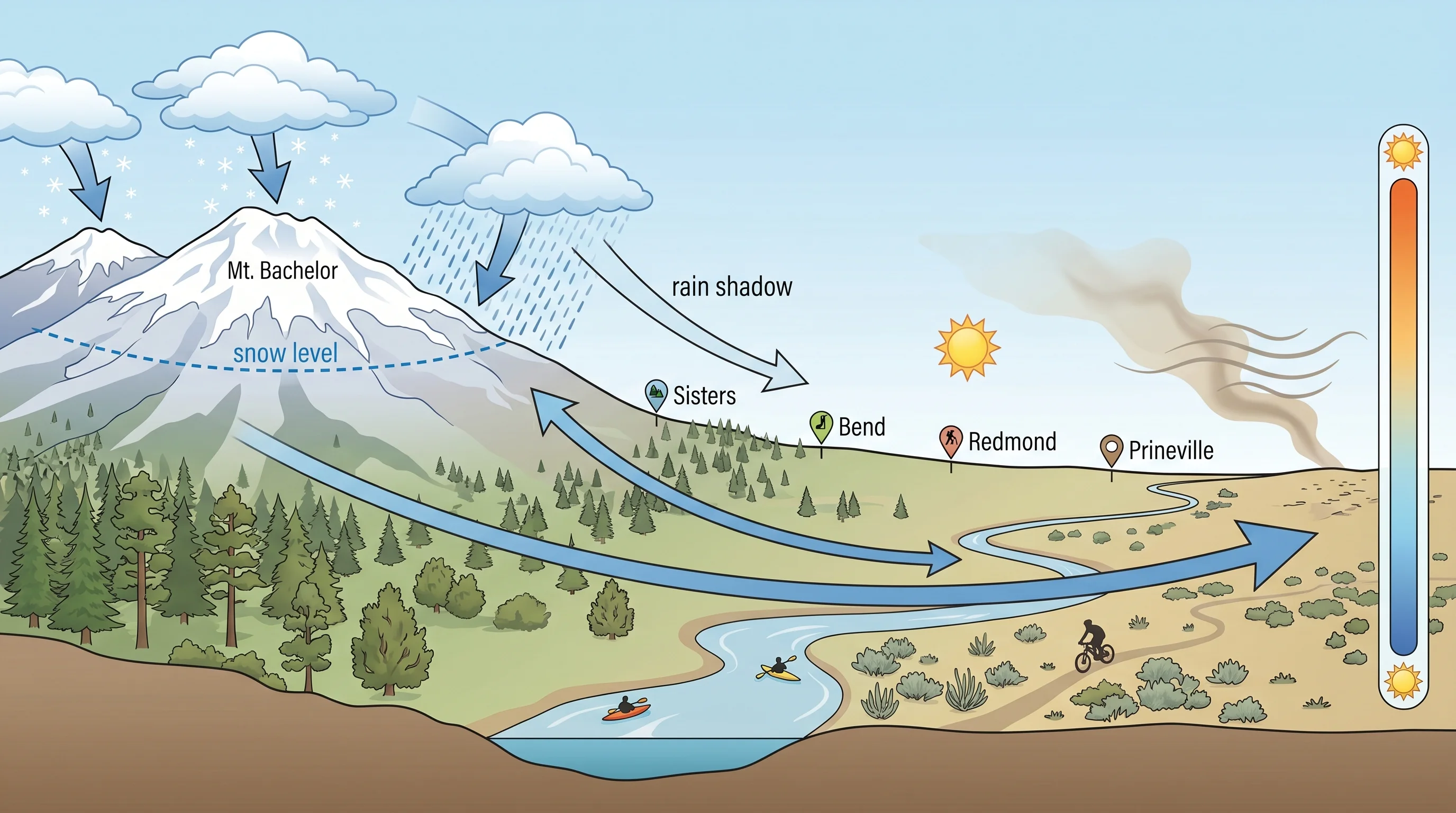
The defining trait is dryness, and it comes from geography. Pacific storms arrive from the west, rise over the Cascades, and drop most of their moisture as rain and snow on the windward slopes and crest. The air that descends into Central Oregon has been wrung out, and as it sinks it warms and dries further, which suppresses clouds and leaves the famous high-desert sun. The result is a climate that is sunny far more often than the rest of Oregon but also colder at night, windier in spring, and smokier in late summer than newcomers expect. For the mechanisms behind all of it, see why Central Oregon weather changes so fast.
Snow Level: Why It Matters Across Central Oregon
Snow level, the elevation where falling precipitation changes from rain to snow, is the single most useful Central Oregon forecast number. It decides whether the towns get rain while the Cascades get buried, and because the region spans such a wide elevation range, a snow level sitting at 4,000 feet can mean rain in Redmond, a rain-snow mix in Bend, and heavy snow at Mt. Bachelor all in the same hour. Higher towns like Sunriver often see snow when lower ones see rain.
Bend's elevation sits right in the zone where the snow level commonly lands, which is why its winters are so variable: a shift of just a few hundred feet in the snow level turns a storm from snow to slush to cold rain. That makes the snow level, rather than the simple chance of precipitation, the number to watch in any winter forecast here. It also drives one of the most-asked local questions, why it can rain in Bend but snow at Mt. Bachelor. For how to read it day to day, see the Oregon snow level map.
Smoke: The Summer Wildcard
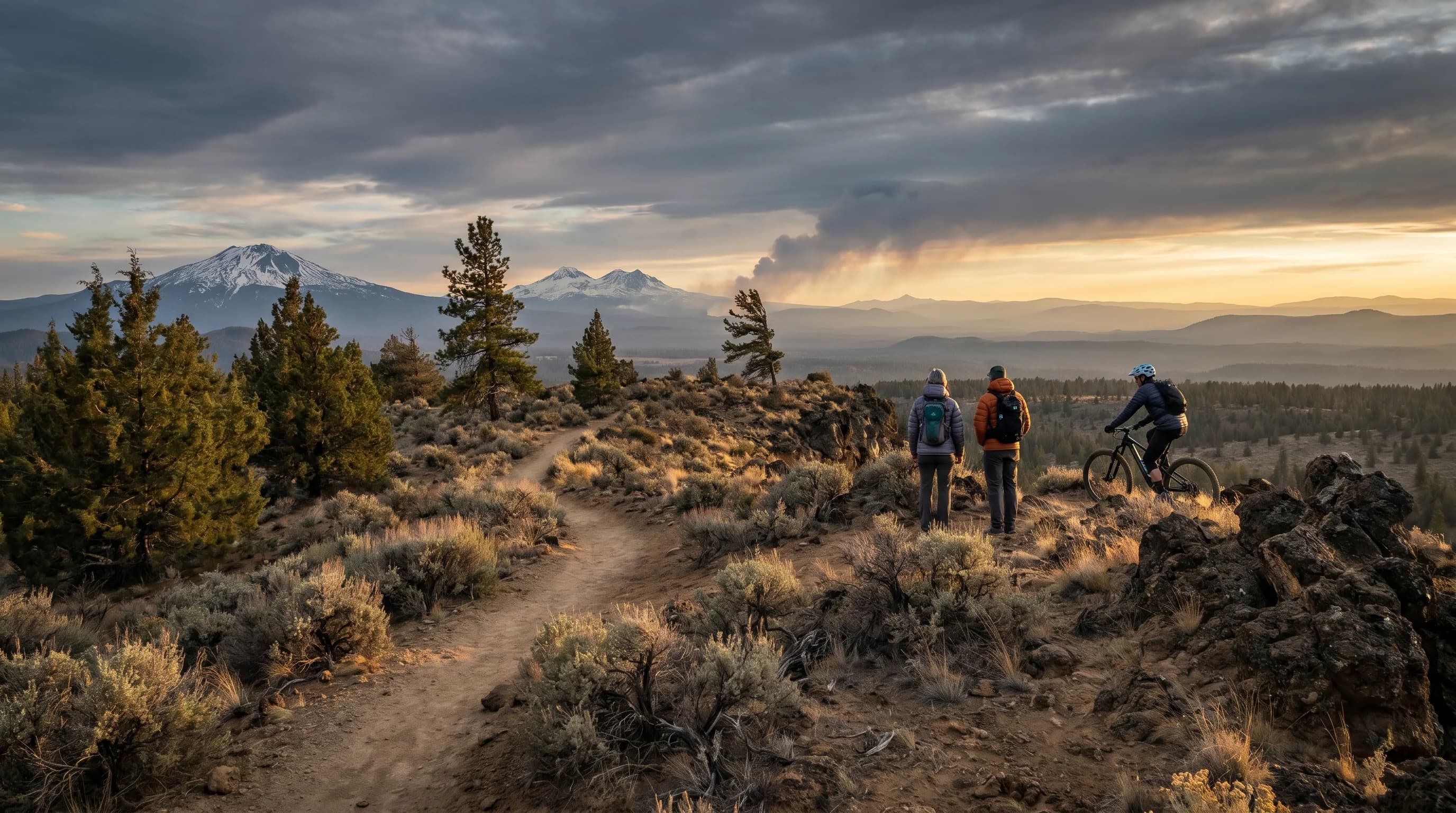
Wildfire smoke is Central Oregon's biggest summer wildcard. It drifts into the region from fires across the West and settles in the Deschutes Basin, and air quality can swing from pristine to hazardous within a day as the wind shifts. The season generally runs from July into September, with August usually the smokiest stretch, and it fades quickly once the first fall rains arrive.
The smoke does not have to come from a local fire. Plumes routinely ride in on the wind from California, Washington, or the west Cascades and pool in the basin, which is why Bend's air can be hazardous with no flames anywhere nearby. Because the fine particles in smoke, measured as PM2.5, are a genuine health concern, the practical move during smoke season is to check an air-quality reading before committing to a hard day outside rather than judging by the sky alone. Where the smoke comes from and when it clears is covered in Central Oregon smoke season.
Wind: Gusty High-Desert Afternoons
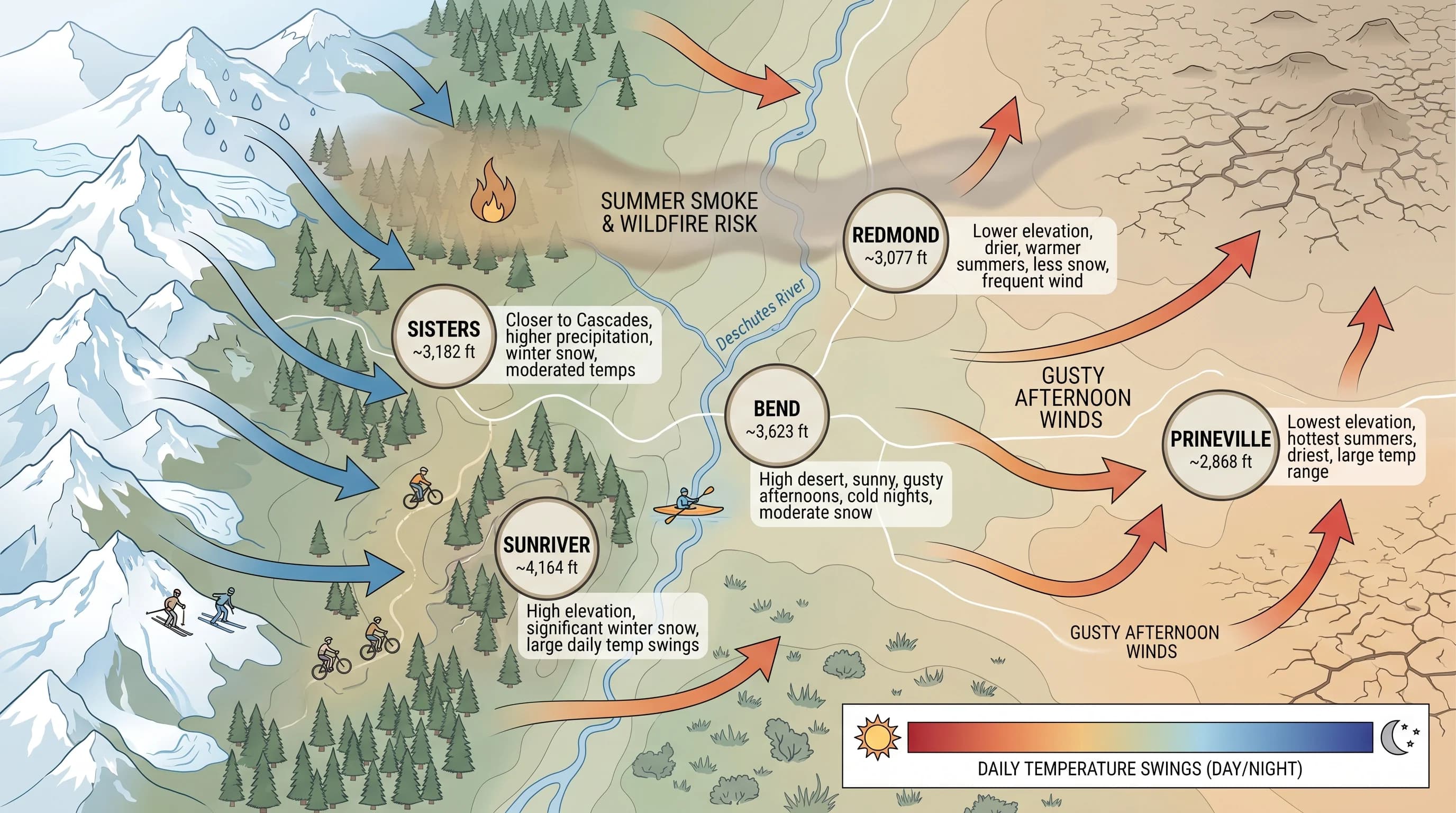
Central Oregon afternoons often turn gusty as the high desert heats unevenly and the rising warm air mixes stronger winds down to the surface. Mornings are usually calmest, and the wind builds through the afternoon, strongest in spring and early summer when the temperature contrasts that drive it are sharpest. Redmond and the open, exposed areas feel it most, while sheltered, tree-lined spots stay calmer.
Direction matters as much as speed. A dry east wind can lower humidity and push fire risk sharply higher, while a west wind can either clear local smoke or import it from Cascade fires. For paddlers and cyclists, the afternoon gusts decide which lakes are calm and which open stretches are a fight. The pattern is explained in why Bend afternoons get gusty, and wind direction itself is covered in east wind versus west wind.
Temperature Swings: Hot Days, Cold Nights
Central Oregon's dry air and elevation produce some of the biggest day-to-night temperature swings in the state, often 35 to 45 degrees in summer. The reason is that dry air holds little heat: humid air traps the warmth the ground releases at night, but the high desert's dry, clear skies let that heat radiate straight back to space after sunset. A 90-degree July afternoon can fall into the 40s by dawn.
The swing is widest in the highest, most sheltered basins, where cold air pools overnight, and it shapes practical decisions across the region: frost is possible in nearly any month at higher elevations, campers need real overnight gear even in July, and gardeners work within a short, careful growing season. It is the single most consistent feature of Central Oregon weather, present in every season, and the reason a warm afternoon never guarantees a warm evening. The full explanation, including why deserts get cold at night, is in why Central Oregon has such big temperature swings.
Central Oregon Through the Seasons
Winter is cold and snowy, with the basins prone to freezing fog and hard overnight lows while the real snow stacks up in the Cascades. Spring is the most changeable season, alternating warm sun, late snow, mud, and the region's windiest stretches as the atmosphere transitions. Summer is hot, bright, and very dry, with afternoon highs in the upper 80s and low 90s, cold nights, building afternoon thunderstorms over the mountains, and the wildfire-smoke risk that defines late summer.
Fall is many locals' favorite: clear, crisp, settled days, cool nights, and the first frosts and mountain snow returning by October, with the smoke usually gone after the first rains. Across all four seasons the constants are the same, dryness, abundant sun, and the daily temperature swing, which is why those traits, more than any single season, define what living and traveling here actually feels like.
How Does Weather Vary Across Central Oregon Towns?
Weather varies across Central Oregon mostly by elevation and distance from the Cascades. Higher, mountain-adjacent places like Sisters and Sunriver are cooler and snowier, while lower east-side towns like Redmond run warmer, drier, and windier. Bend sits in the middle as the regional hub. The lower east-side towns of Prineville and Madras run warmer and drier still, while Sisters, closest to the Cascades, sees the most snow of the valley towns.
The same storm can rain in Madras, snow in Sunriver, and dump feet at Mt. Bachelor, all on the same afternoon, and a calm clear night can leave one basin frosty while a ridge above stays mild. Once you read the region as a stack of elevation bands in a rain shadow rather than a single uniform place, those contrasts between towns on the same day stop being a surprise and start being predictable. Checking conditions for your specific town and elevation, not just a regional headline, is the key to planning well here.