A temperature inversion is when a layer of warm air sits on top of cooler air near the ground, flipping the normal pattern where air gets colder as you go up. That warm lid traps the cold air, along with any fog or pollution, close to the surface. It is also called a thermal inversion, and it is the reason valleys fill with fog, smog, and stubborn cold that will not clear for days. Inversions are one of the most important and least understood drivers of winter weather, and in basin-and-mountain terrain like Central Oregon they shape everything from freezing fog to wood-smoke haze to the timing of a hard overnight freeze.
What Is a Temperature Inversion?
To understand an inversion you first have to understand the normal state of the atmosphere. Under typical conditions, air temperature falls as you climb, by roughly 3.5 degrees Fahrenheit for every thousand feet in still, dry air. This steady cooling with height is called the lapse rate, and it is what lets warm air near the ground rise: warm air is less dense than the cooler air above it, so it floats upward and mixes, carrying moisture, heat, and pollutants up and away from the surface. That constant vertical churn is why the lower atmosphere usually stays well mixed.
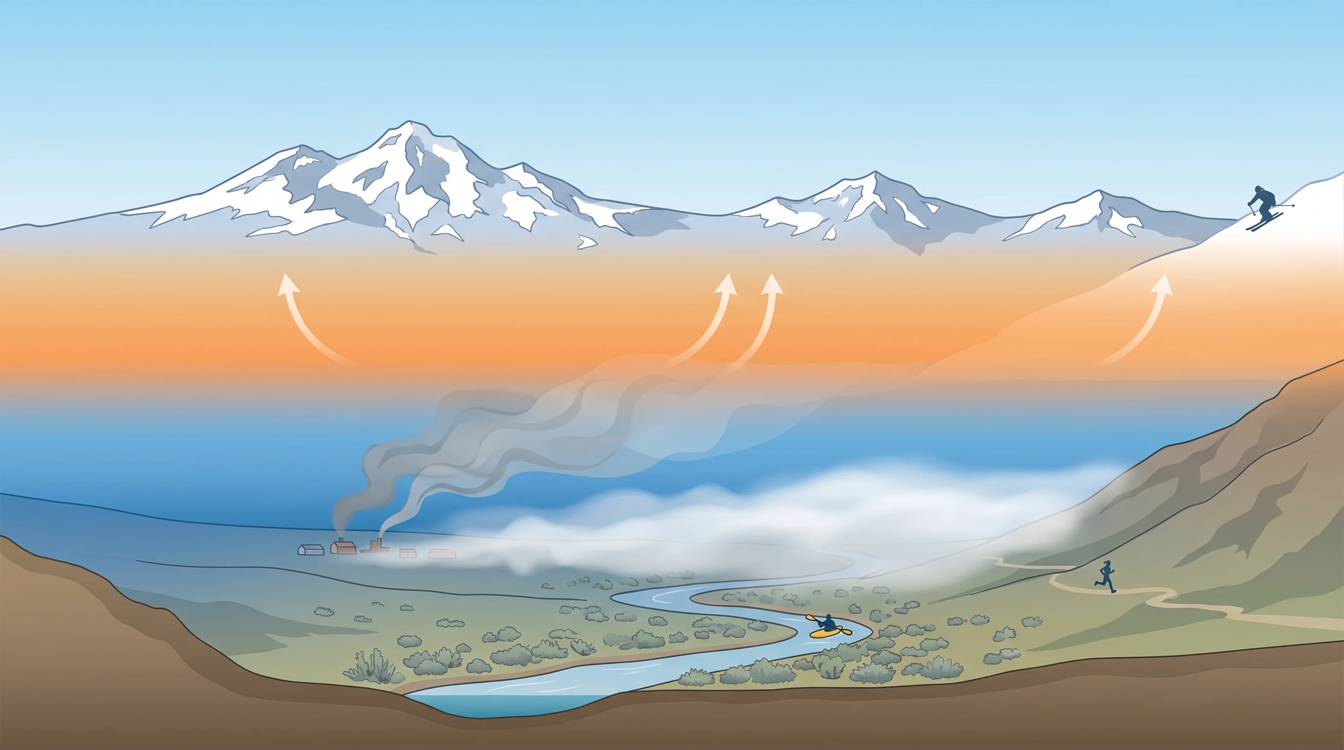
A temperature inversion reverses that profile over some layer. Instead of cooling with height, the air actually warms with height for a stretch, so a band of warmer air ends up sitting on top of colder, denser air below. Because the cold air at the surface is now heavier than the warm air above it, it has no tendency to rise. The warm band becomes a lid, and the air beneath it goes still. Everything held in that surface layer, the chill, the moisture, the smoke, stays put because the usual upward escape route is closed off. The base of that warm lid is sometimes called the mixing height, and the lower it sits, the more concentrated whatever is trapped below becomes.
What Causes a Temperature Inversion?
The most common type is the radiation inversion, and it forms on clear, calm nights. After sunset, the ground radiates its stored heat away to space as infrared energy. With no clouds to trap and return that heat and no wind to stir the air, the surface cools quickly, and it chills the thin layer of air in direct contact with it. By a few hours before dawn, that surface air can be much colder than the air a few hundred feet up, which never touched the cooling ground. The result is a shallow but sharp inversion that is usually strongest right at sunrise and erodes as the sun warms the surface back up.
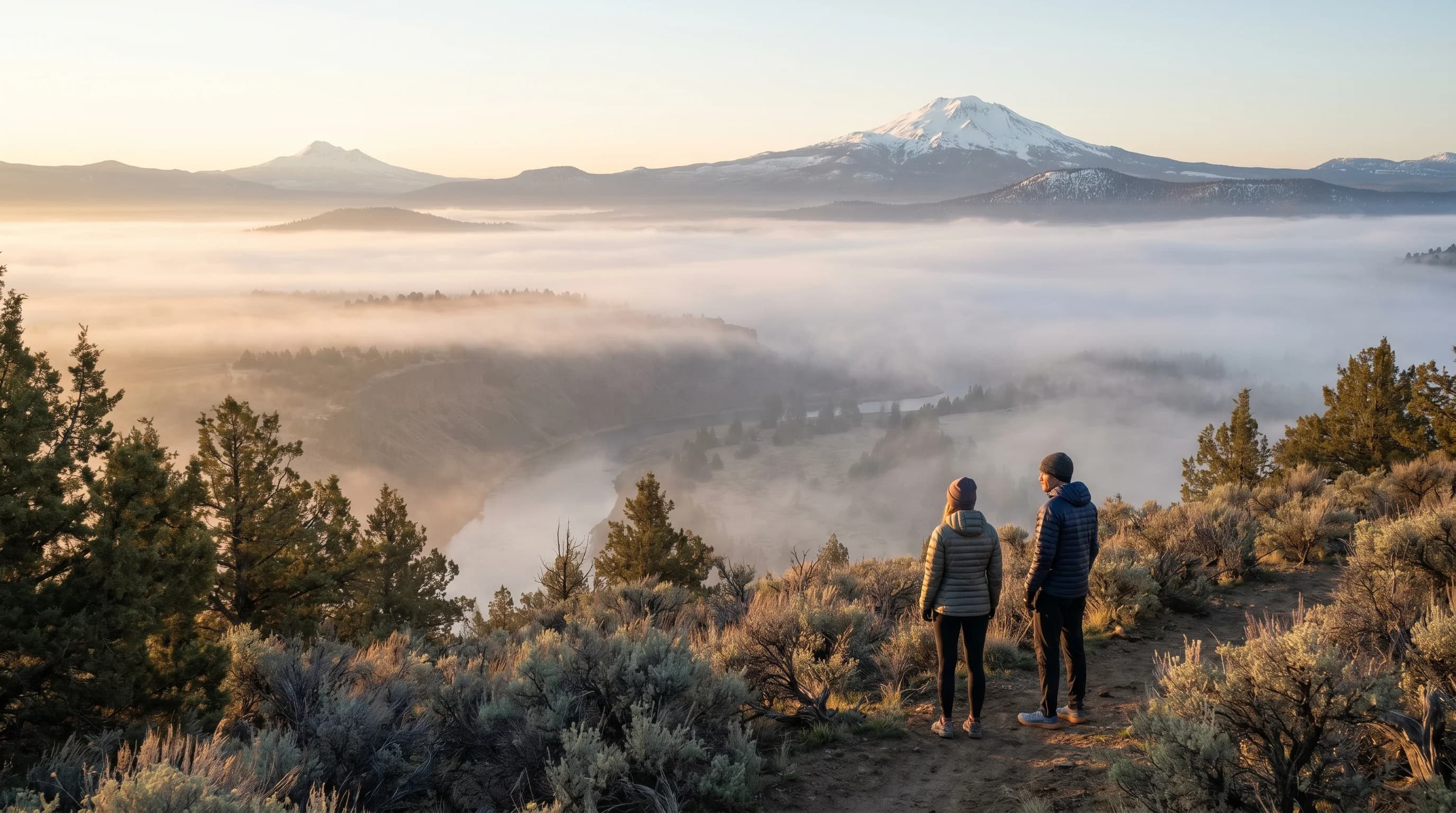
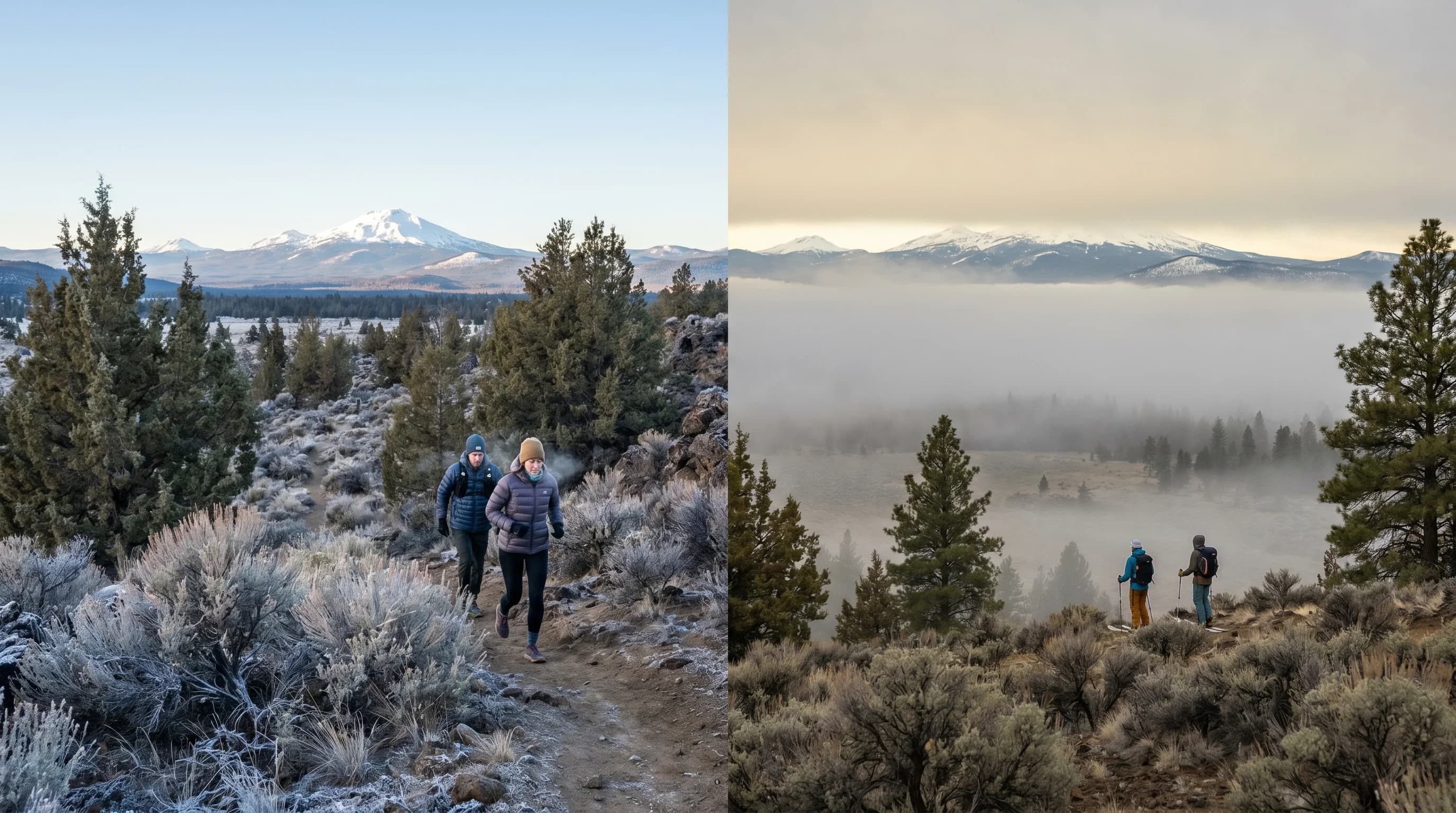
Cold-air drainage makes radiation inversions much stronger in hilly terrain. Cold air is dense, so once it forms on slopes and high ground it flows downhill like water and pools in the lowest spots: valley floors, basins, and hollows. A town in a bowl can sit in a deep reservoir of cold air that drained in overnight from the surrounding higher ground, while a hillside a few hundred feet up stays noticeably warmer. This is why the coldest morning readings in a region so often come from low, sheltered basins rather than exposed ridgetops.
A second, larger-scale type is the subsidence inversion, produced by high pressure. In a strong high, air slowly sinks over a wide area, and sinking air compresses and warms as it descends. That warming aloft can build a warm layer thousands of feet up that caps the whole region for days. Subsidence inversions are behind the long, stagnant high-pressure spells that lock in haze and cold across an entire basin in midwinter, often layered on top of the nightly radiation inversions near the ground.
Why Do Inversions Trap Fog, Smog, and Cold Air?
Inversions trap things because they shut off vertical mixing. In normally structured air, smoke from a chimney or moisture from the ground rises, spreads out, and dilutes as it climbs into the deep, churning lower atmosphere. Under an inversion, anything released at the surface rises only until it reaches the warm cap, then spreads sideways and accumulates in the shallow cold layer below. With a low mixing height, there is very little air to dilute into, so concentrations climb fast.
This is also self-reinforcing, which is why strong inversions are so stubborn. Once fog or haze forms under the cap, it reflects incoming sunlight back to space during the day, so the surface cannot warm up enough to break the inversion. The cold layer survives into a second night, drains in even more cold air, and deepens. That feedback is exactly why freezing fog and winter wood smoke can linger for days, clearing only when a storm or a strong wind finally scours the basin out.
Where and When Do Temperature Inversions Happen?
Temperature inversions are most common in valleys and basins on clear, calm winter nights, and during the long, stagnant high-pressure spells that settle over the interior West in the cold season. Bowl-shaped terrain is the key ingredient, because it both pools draining cold air and shelters it from the wind that would otherwise mix it out. The longer the nights and the weaker the sun, the more the atmosphere favors them, which is why they are a deep-winter signature and fade as spring strengthens the daytime heating.
Central Oregon's Deschutes Basin is a textbook setting. Surrounded by higher terrain and the Cascades, with long clear nights and dry air that radiates heat away efficiently, the basin pools cold air around Bend, Redmond, Sunriver, and La Pine night after night in winter. That is why inversions are such a defining part of Central Oregon winters, producing the region's freezing fog, trapped wood smoke, and the surprisingly cold morning lows in the lowest basins.
How Do Temperature Inversions Affect Air Quality?
Air quality is where inversions do their most visible damage. By capping the shallow surface layer, an inversion concentrates everything emitted into it: wood smoke from stoves, vehicle exhaust, and any lingering wildfire smoke. During a strong winter inversion, fine-particle pollution (PM2.5) can climb to unhealthy levels with no new sources at all, simply because the same daily emissions are piling up in a thinner and thinner pocket of air. The longer the inversion holds, the worse it gets, which is why multi-day cold spells often end with the worst air of the winter.
The cure is almost always mechanical: the inversion has to be broken. Strong daytime heating can erode it from below by warming the surface until the cold layer finally rises and mixes, but in deep winter the weak sun often cannot do the job. More reliably, an incoming storm or a strong wind mixes the trapped air out and replaces it with fresh air. If you have ever wondered why the air quality is so bad on a cold, calm day, a trapped inversion is usually the answer, and the forecast for wind or a frontal passage is your best clue for when it will finally clear. Once you picture that warm lid sitting over a basin and the still, concentrating air beneath it, the whole winter pattern of stuck cold, fog, and haze starts to make sense.