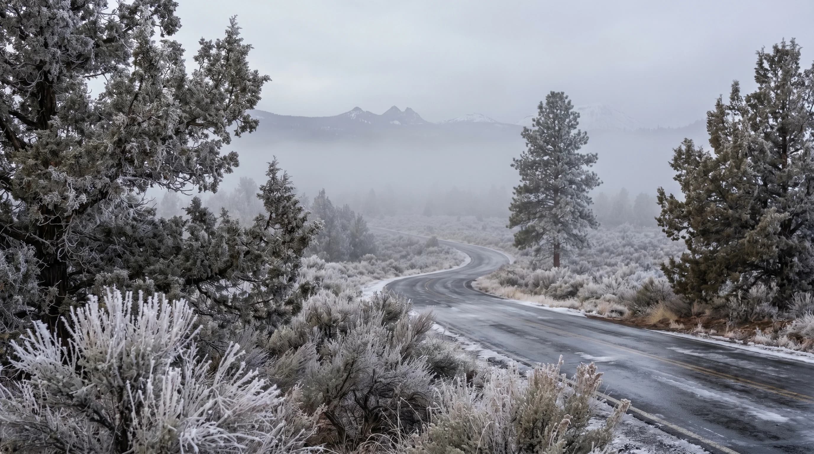
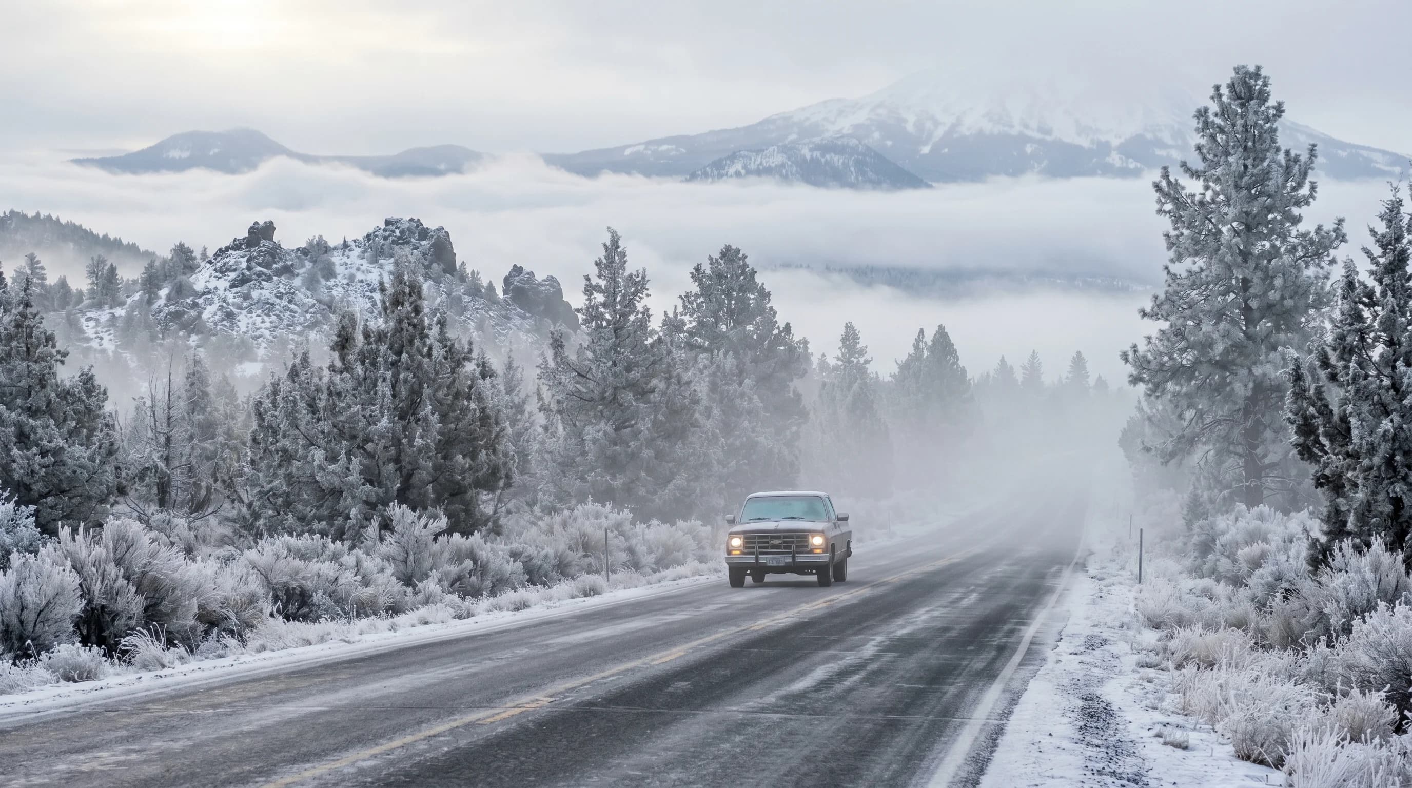
Freezing fog is the single most underrated winter hazard in Central Oregon. It glazes roads, sidewalks, and windshields with ice on mornings when not a drop of rain or flake of snow has fallen, and it catches out drivers who only think of winter as a snow problem. In the Deschutes Basin, freezing fog forms when cold, humid air pools near the ground on calm, clear nights and the tiny fog droplets are supercooled, freezing instantly onto every surface they touch. It is most common from November through February, and on the worst mornings it can turn a dry-looking road into a sheet of clear ice.
What Is Freezing Fog?
Freezing fog is fog made of supercooled water droplets that freeze the instant they touch a surface, coating roads, trees, and windshields with ice even though no precipitation has fallen. The fog itself is ordinary fog, a cloud of tiny liquid droplets suspended near the ground, but its temperature is below freezing. Water droplets that small can stay liquid well below 32 degrees, a state called supercooling, because they lack the nucleus they need to organize into ice crystals. The moment they contact a solid surface, that surface provides the trigger and they freeze on contact.
The result is one of two kinds of ice. On surfaces, the freezing droplets build up rime ice, the white, feathery, granular coating that accumulates on the upwind side of trees, fences, and mirrors. On roads, the same process leaves a thin, clear, treacherous glaze that is far harder to see than snow. This is the crucial difference between freezing fog and a snowstorm: a snowy road looks dangerous, while a freezing-fog road can look merely wet or even dry while being coated in clear ice.
Why the Deschutes Basin Is So Prone to It
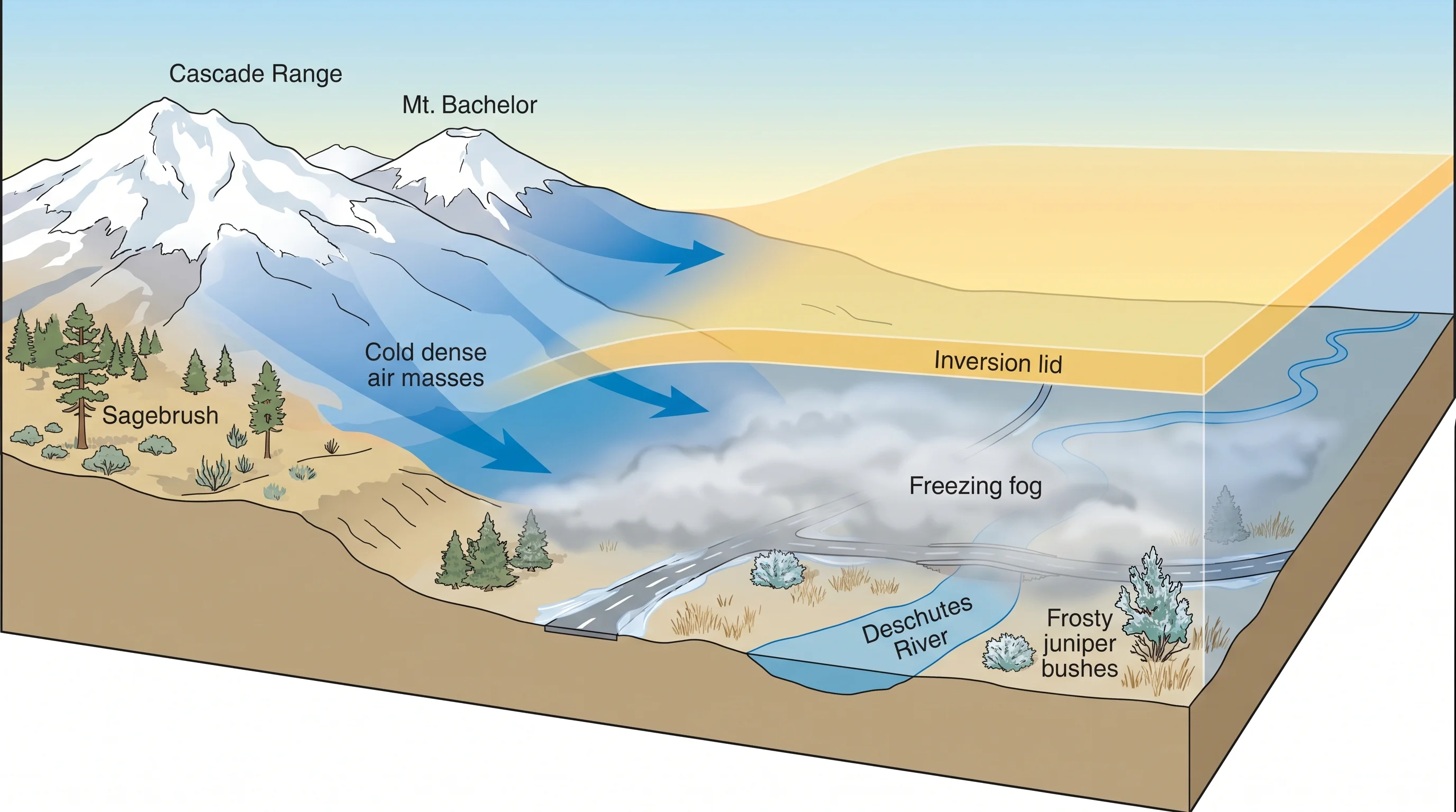
Central Oregon gets frequent freezing fog because the Deschutes Basin is a natural cold-air trap, and the high desert's clear, calm winter nights let cold, humid air pool right where it can freeze. The terrain is the foundation: Bend, Redmond, and the surrounding basin sit in a broad low spot ringed by higher ground and the Cascades, and on calm, clear nights cold air, which is denser than warm air, drains downhill off the surrounding terrain and settles into the basin. This is cold-air pooling, and it is the engine behind the region's winter fog and ice.
Layered on top of the pooling is a temperature inversion, where the cold air sits trapped beneath a lid of warmer air aloft, so it cannot mix out or warm up. Inside that trapped layer, any available moisture, from the Deschutes River, from snowmelt, from the soil, condenses into fog as the air cools below its dew point. Because the trapped air is already below freezing, the fog is freezing fog. The same inversions that trap the fog also trap cold and wood smoke, the full mechanism covered in temperature inversions in Central Oregon.
Why It Makes Roads So Dangerous
Freezing fog is dangerous mainly because the ice it leaves is nearly invisible, forming a clear glaze that looks like wet or dry pavement until a vehicle loses traction. Unlike snow, which signals its own danger, freezing-fog ice gives almost no visual warning, and it is closely related to black ice, the thin transparent ice that takes on the dark color of the road beneath it. Drivers approach at normal speeds, brake or steer as usual, and find there is no grip.
Certain spots are far worse than others. Bridges and overpasses freeze first and worst because they lose heat from both top and bottom, with no ground warmth underneath. Shaded stretches, north-facing roads, and low spots where the cold air is deepest stay icy long after sunlit pavement has thawed. And because Central Oregon's winter days are short and the sun stays low, the ice clears slowly, sometimes lingering all day in the shade during a deep inversion. The relationship to black ice is covered in what is black ice, and the rime that builds on surfaces in what is rime ice.
When Freezing Fog Is Most Common
Freezing fog is most common in Central Oregon from November through February, peaking in the depths of winter when nights are longest, coldest, and most often calm and clear. The recipe requires several ingredients to line up: temperatures below freezing, enough low-level moisture to form fog, light or calm winds so the cold air can pool undisturbed, and clear skies that let the ground radiate its heat away and chill the air near the surface. Strong high-pressure systems, which bring exactly these calm, clear, cold conditions, are the classic setup.
Mornings are the prime time, since the air is coldest just before and after dawn after a full night of radiational cooling. The fog often forms overnight, peaks around sunrise, and burns off through the morning, though in a deep, stubborn inversion it can persist for hours or even all day. Wind is the enemy of freezing fog: a breeze mixes the cold pooled air with warmer air aloft and breaks up both the inversion and the fog. This is part of why Central Oregon has such big day-to-night temperature swings, with the same clear, calm nights driving both the deep cold and the fog.
How to Stay Safe in Freezing Fog
The most important thing to know about freezing fog is to treat every cold, foggy, calm Central Oregon morning as if the roads are icy, even when no snow or rain has fallen and the pavement looks clear. Slow down, increase your following distance, and brake and steer gently, since sudden inputs are what break traction on a glazed surface. Give yourself extra time on winter mornings rather than rushing into conditions that punish abrupt maneuvers.
Be especially cautious on bridges, overpasses, shaded curves, and low-lying stretches, which freeze first and thaw last, and remember that a road that was clear on the way out can be iced over on the way back as the fog settles. Defrost and clear all your windows fully, because freezing fog rimes up windshields and mirrors. Check the forecast for fog and freezing fog advisories, which the National Weather Service issues for exactly these conditions. With awareness and a slower pace, freezing fog is manageable, but it demands the respect that its invisible ice earns. For how it fits the broader winter picture, see the Central Oregon climate guide.