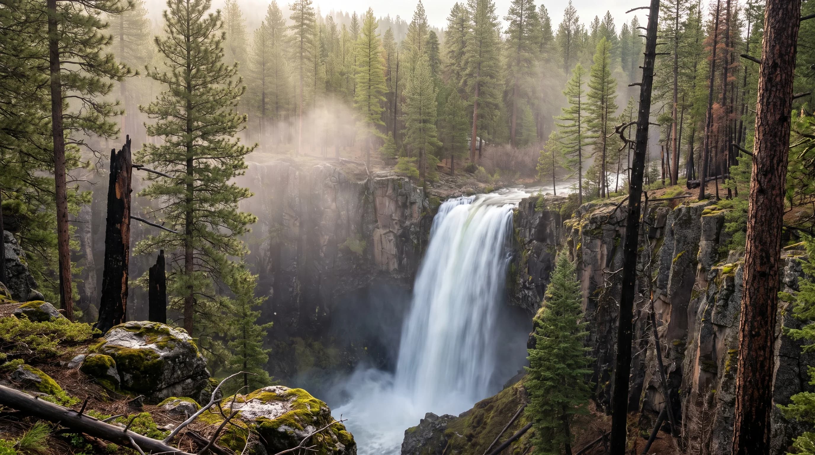
The best time to see most waterfalls near Bend is May to June, when Cascade snowmelt peaks; Tumalo Falls is fullest in May. Benham Falls on the Deschutes runs highest in July from reservoir releases, and Sahalie and Koosah Falls on the spring-fed McKenzie stay strong all year. In winter, Tumalo Falls requires a snowy walk from Skyliner Sno-Park.
Central Oregon's waterfalls do not all peak at the same time, because they do not drink from the same source. Tumalo Falls drops 97 feet, and its creek carries nearly four times as much water in May as in September. Every waterfall has a water source, and the source sets the season. This guide groups the falls near Bend by snowmelt, springs and reservoir releases, then adds the winter twist: road gates and frozen falls.
When Is the Best Time to See Waterfalls Near Bend?
Late May and June are the best all-around months: snowmelt falls are near their peak, the Deschutes is rising, and most trailheads are open. The table shows how each fall's source sets its season.
| Waterfall | Water source | Peak flow | Winter access |
|---|---|---|---|
| Tumalo Falls (97 ft) | Snowmelt | May-June | Road gated; walk or ski from Skyliner Sno-Park |
| Benham, Dillon and Lava Island Falls | Deschutes, reservoir releases | June-September | Trails open; access roads may be snowy |
| Sahalie (73 ft) and Koosah (about 64 ft) Falls | McKenzie springs and snowmelt | April-May; strong all year | OR 126 open; paths can be icy |
| Proxy Falls (226 ft) | Snowmelt | June-July | OR 242 closed from about November to June |
| Steelhead Falls (about 20 ft) | Middle Deschutes below the canals, plus springs | November-April; flows all year | Open; check the road |
Peak months from OWRD and USGS gauge averages, 1991-2025. Heights from published sources, which vary slightly; some list Sahalie Falls near 100 feet. Road seasons vary by year; check the Deschutes and Willamette national forests and ODOT before you go.
Start with the fall everyone knows.
When Does Tumalo Falls Run Biggest?
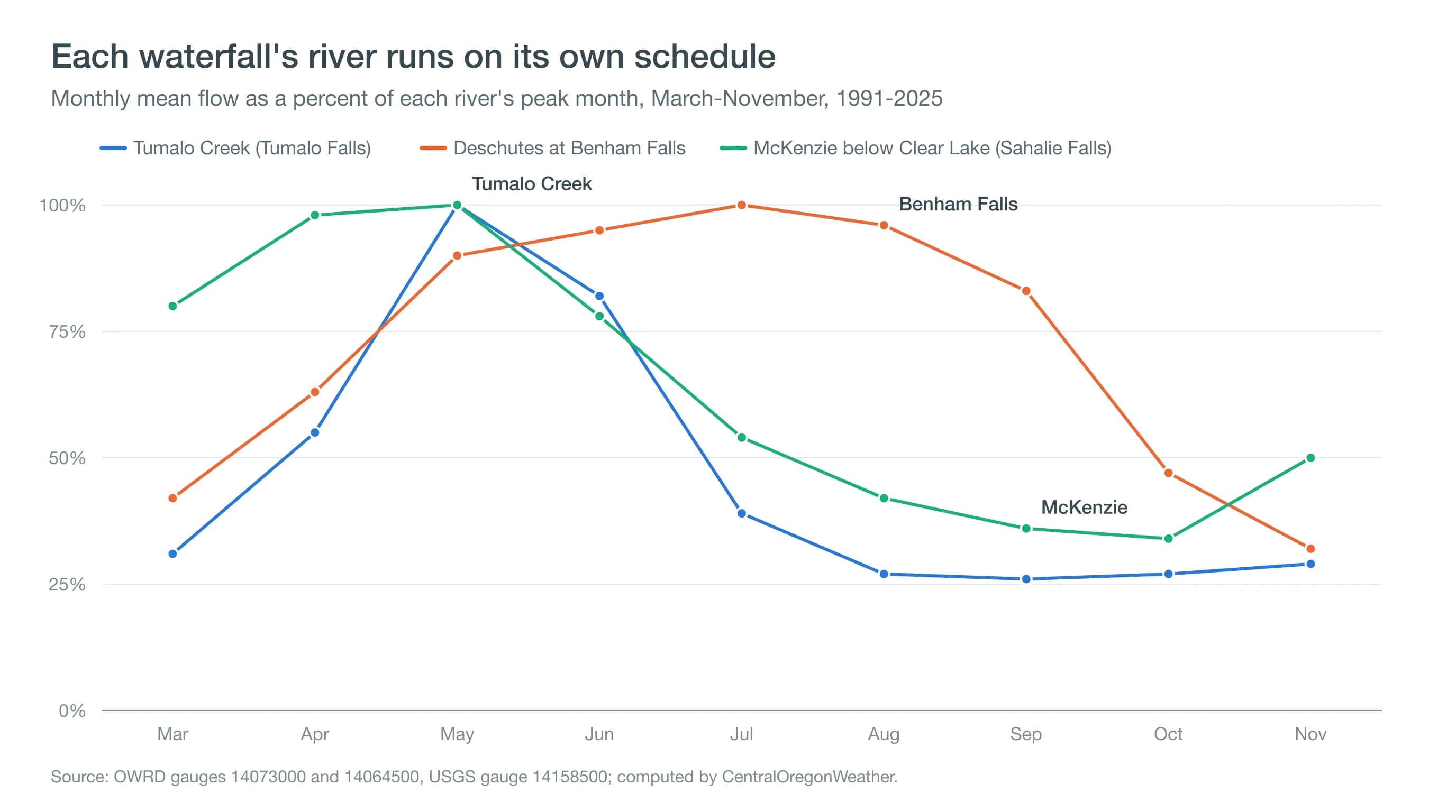
Tumalo Falls runs biggest in May, when the snowpack in the upper Tumalo Creek basin melts fastest. From 1991 to 2025, the creek averaged about 173 cubic feet per second (cfs) in May and 141 in June, then fell to about 45 by September, according to the Oregon Water Resources Department gauge near Shevlin Park, about 10 miles below the falls.
The timing follows the snow. Nearby, the Three Creeks Meadow SNOTEL site melts out by a median of May 19, and the creek peaks as the high snowfields drain. In a snow-drought year, the peak is usually smaller and earlier; in 2026, that site was bare by early March. Middle and upper Tumalo Falls, farther up the North Fork trail, follow the same calendar. Our guide to snow water equivalent explains how to read the snowpack that feeds it. The Deschutes falls follow a calendar set by people as much as by snow.
Why Are Benham and Dillon Falls Fullest in Summer?
Benham and Dillon Falls are fullest in summer because reservoirs upstream release stored water for irrigation. The Deschutes at Benham Falls averaged about 1,880 cfs in July and only about 600 cfs in November from 1991 to 2025, the reverse of a natural snowmelt river.
Wickiup and Crane Prairie reservoirs store winter flow and release it from spring into fall, so the river through the Benham, Dillon and Lava Island falls stretch runs high and loud all summer. The Deschutes River Trail, heading upstream from Meadow Day Use Area, passes all three. Our guide to floating the Deschutes in Bend follows the same water downstream. West of the crest, the McKenzie plays by different rules.
Why Do Sahalie and Koosah Falls Flow All Year?
Sahalie and Koosah Falls flow all year because the upper McKenzie River is fed by large springs that release snowmelt slowly through young lava. The river leaving Clear Lake, just above the falls, averaged about 634 cfs in May and about 218 in October from 1991 to 2025. Even its low point is more water than Tumalo Creek carries at its May peak.
The water is cold and steady too: from 2017 to 2025, it averaged about 39°F in winter and only about 49°F in July. Sahalie Falls drops about 73 feet and Koosah about 64 feet, linked by a loop trail off OR 126, which stays open in winter. Downstream, much of the river vanishes into lava and reappears at Tamolitch Blue Pool; see Tamolitch Blue Pool for its forecast. Some falls are only reachable half the year.
One more fall runs on the irrigation calendar in reverse, on the dry side of the mountains. Steelhead Falls, about 20 feet high, spills across the Deschutes in a basalt canyon near Crooked River Ranch, northwest of Redmond. Canals take much of the river's summer flow in Bend, so the fall runs fullest from late fall through early spring, after diversions stop, while springs below Bend keep it flowing all year. That is also when the short trail is most pleasant, with Cascade trailheads still buried and the canyon not yet baking. See Steelhead Falls before you go.
Can You Drive to Tumalo Falls in Winter?
No. Forest Road 4603 to the Tumalo Falls viewpoint usually closes to vehicles from about November to late May because of snow. In winter, visitors walk, snowshoe or ski about 6 miles round trip from Skyliner Sno-Park, where an Oregon Sno-Park permit is required.
During long cold snaps, spray around Tumalo Falls freezes into columns and curtains of ice, though the creek usually keeps flowing behind them. On the same subzero mornings, spring-fed rivers can steam; see steam fog on the Deschutes. Proxy Falls, which drops 226 feet, is reached from OR 242, the McKenzie Pass highway, which closes from about November until it reopens in June. Read our guide to Cascade passes in winter. Whatever the season, trail conditions follow the weather.
What Should You Check Before a Waterfall Trip?
- Flow: OWRD and USGS publish real-time gauge readings for Tumalo Creek, the Deschutes at Benham Falls and the McKenzie at Clear Lake.
- Snow on the trail: higher trailheads can hold snow into June after a big winter.
- Afternoon storms: summer thunderstorms build over the Cascades; start early. See lightning safety for hikers.
- Smoke: August and September can bring wildfire smoke; check the smoke forecast.
- Ice: in winter, spray zones and stairs near falls glaze over; wear traction devices.
May is a good month for the whole circuit; see Bend weather in May.
Deep Dive: How Do Snowmelt, Springs and Dams Set a River's Rhythm?
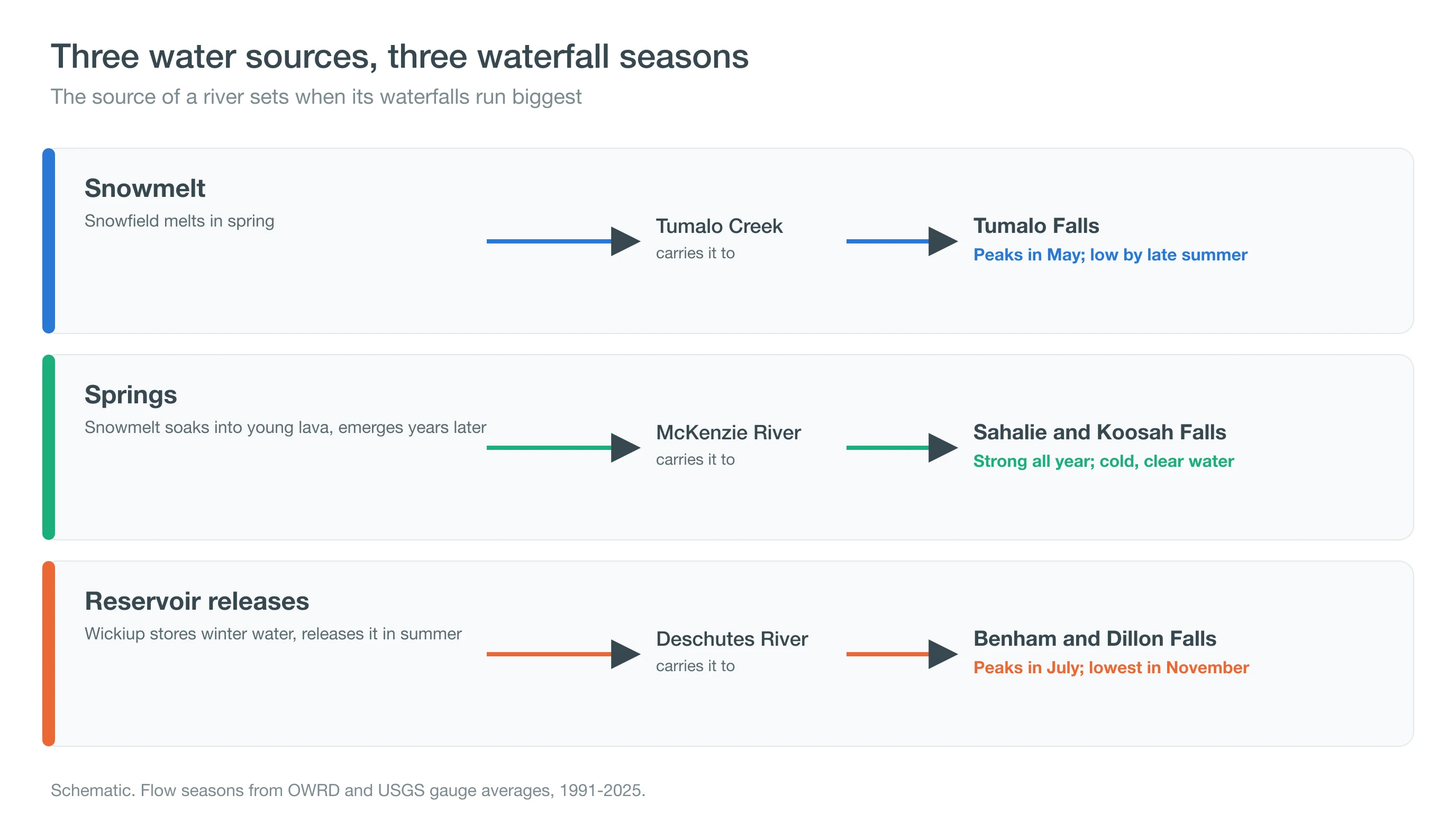
A river's yearly rhythm, its hydrograph, depends on how long water is stored before it reaches the channel: a few months in snow, years in lava aquifers, or exactly as long as a reservoir operator decides.
What Does a Snowmelt Hydrograph Look Like?
Snowmelt streams like Tumalo Creek run low in winter while precipitation is locked up as snow, surge as the snowpack melts in spring, then recede to a low baseflow by late summer. The peak tracks melt-out at nearby snow sensors: when the snowpack is deep and late, the creek peaks later and higher; when it is thin, the peak comes early and small. That is why the same waterfall can look very different in May of two different years.
Measured as a ratio of the wettest month to the driest, Tumalo Creek swings about 3.8 times between May and September. In a snowmelt stream, almost all of that swing comes in a few weeks: the creek more than triples between March and May, then loses more than half its flow between June and July as the last snowfields disappear.
Why Do Spring-Fed Rivers Barely Change?
The upper McKenzie drains young, highly permeable lava between McKenzie and Santiam passes. Snowmelt soaks into that rock and travels underground before emerging at large, cold springs. Research by Anne Jefferson and colleagues at Oregon State University found mean transit times of roughly 3 to 14 years for water from High Cascades springs, which keep summer flows high and water temperatures near 39 to 45°F. The aquifer acts as a giant storage tank that smooths out wet and dry seasons.
The gauges show the smoothing directly. Below Trail Bridge Dam, farther down the upper McKenzie, average monthly flow ranges only from about 666 to 1,296 cfs, less than a twofold swing over the year. Water temperature at the Clear Lake outlet moves just as little, from about 39°F in January and February to about 49°F in July, because most of the water has spent years underground at a constant temperature before it reaches the falls.
How Do Reservoirs Flip the Calendar?
Wickiup and Crane Prairie reservoirs capture flow from fall through spring and release it for irrigation from spring through early fall. Downstream at Benham Falls, the river peaks in July, about 1,880 cfs, and bottoms in November, about 600, the opposite of the natural pattern. Below Bend, canals divert most of that summer water. A waterfall's season there follows a water right as much as the weather.
The reservoir effect has a natural partner. Much of the summer flow in the upper Deschutes also comes from large springs in the porous lava south of Bend, which feed the Fall River, Spring River and the main stem. Those springs keep the river from ever running truly low above Bend, while reservoir releases set the timing of the peak.
How Should You Plan Your Waterfall Trip?
Match the fall to its source: snowmelt falls in May and June, reservoir-fed Deschutes falls in midsummer, and spring-fed McKenzie falls any time of year. Check the Skyliner Sno-Park, Benham Falls and Sahalie and Koosah Falls forecasts before you go.