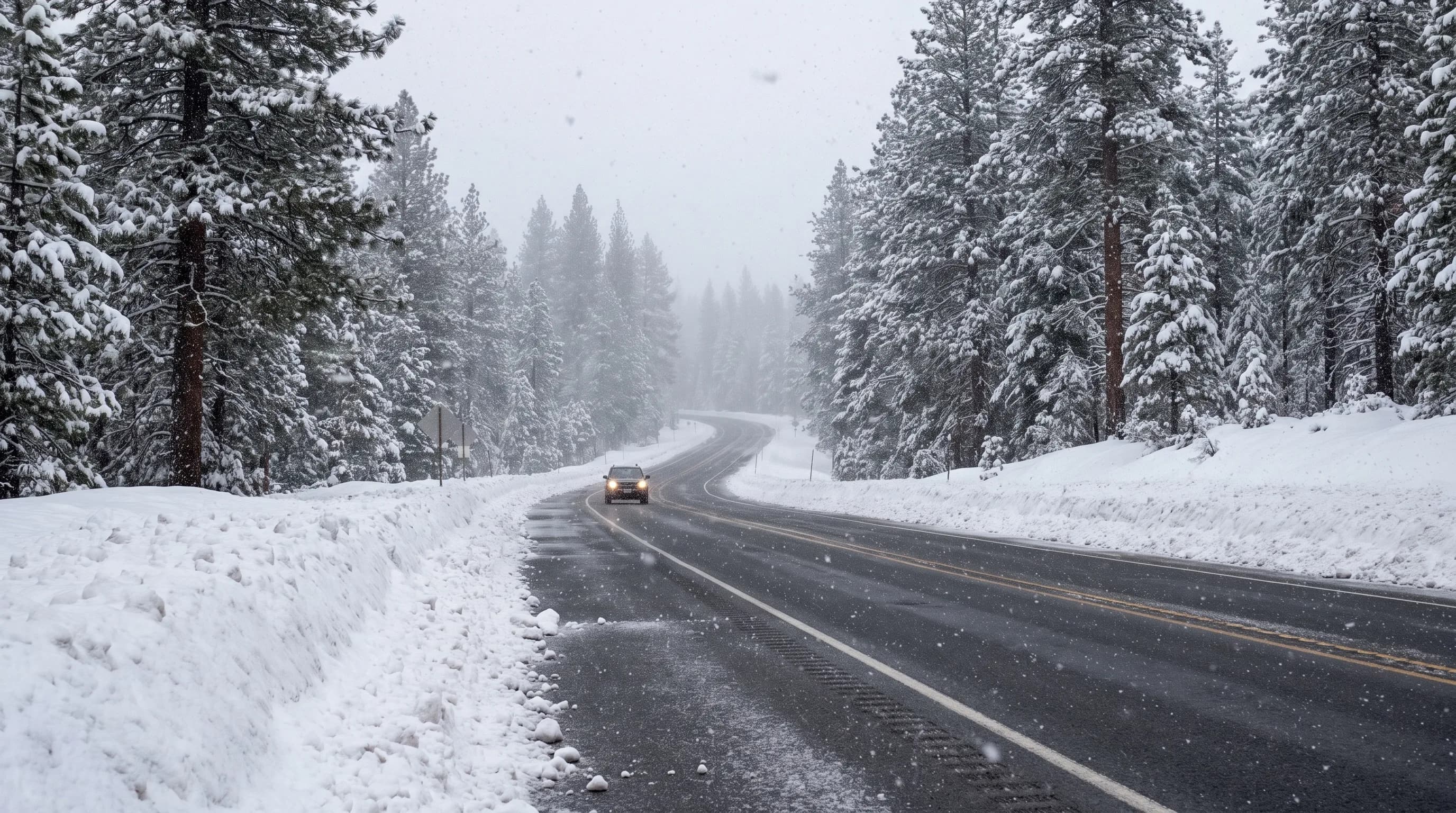
Santiam Pass (4,817 feet, US 20) and Willamette Pass (5,128 feet, OR 58) stay open all winter, but chains or traction tires are often required. Snow sensors near both summits show a lasting snowpack typically forming in the last days of November and melting out in late May. McKenzie Pass (OR 242) closes to vehicles from about November until mid-June.
The passes are where Central Oregon's dry climate ends. Every winter trip between Bend and the Willamette Valley climbs out of the rain shadow and into the Cascade snow belt, where Odell Lake, near Willamette Pass, averages about 190 inches of snow a year against Bend's 22. Each route is a different version of that climb.
Which Central Oregon Passes Are Open in Winter?
Two of the four main routes over the Central Oregon Cascades stay open all winter: US 20 over Santiam Pass and OR 58 over Willamette Pass. OR 242 over McKenzie Pass and the Cascade Lakes Highway beyond Mt. Bachelor are gated for the snow season and not plowed.
| Route | Summit | Winter status | Snow usually lasts | Nearest snow sensor |
|---|---|---|---|---|
| Santiam Pass (US 20) | 4,817 ft | Open all winter; chain controls common | Late Nov. to late May | Hogg Pass (4,800 ft) |
| Willamette Pass (OR 58) | 5,128 ft | Open all winter; chain controls common | Late Nov. to late May | Cascade Summit (5,100 ft) |
| McKenzie Pass (OR 242) | 5,325 ft | Closed to cars about November to mid-June | Late Nov. to early June | McKenzie (4,770 ft) |
| Cascade Lakes Highway past Mt. Bachelor | About 6,000 ft and up | Gated west of Dutchman Flat in winter | Nov. to June | Irish Taylor (5,540 ft) |
Snow season from the median dates a lasting snowpack forms and melts out at the nearest NRCS SNOTEL site, water years 1991-2020. Closures from ODOT and the Deschutes County Road Department. Check ODOT TripCheck for today's conditions.
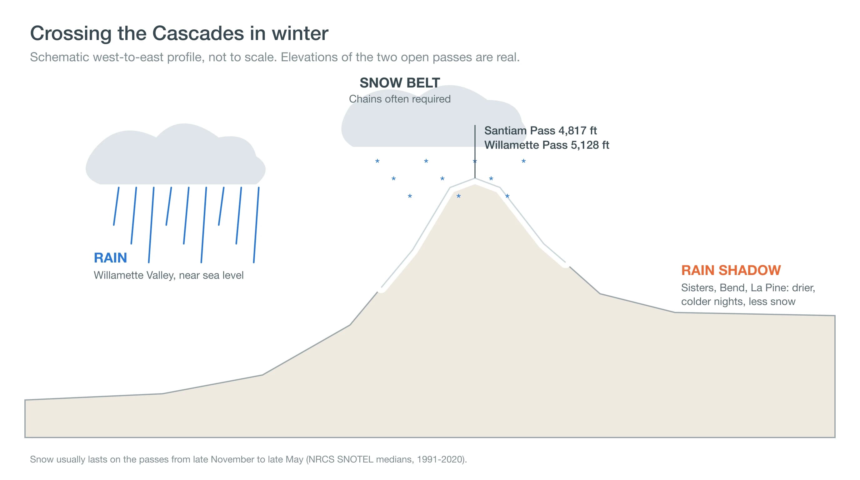
Open does not mean easy. The open passes sit right where Pacific storms dump the most snow, so the drive from dry pavement in Sisters or La Pine to chain controls at the summit can take less than half an hour.
What Is Winter Weather Like on Santiam Pass?
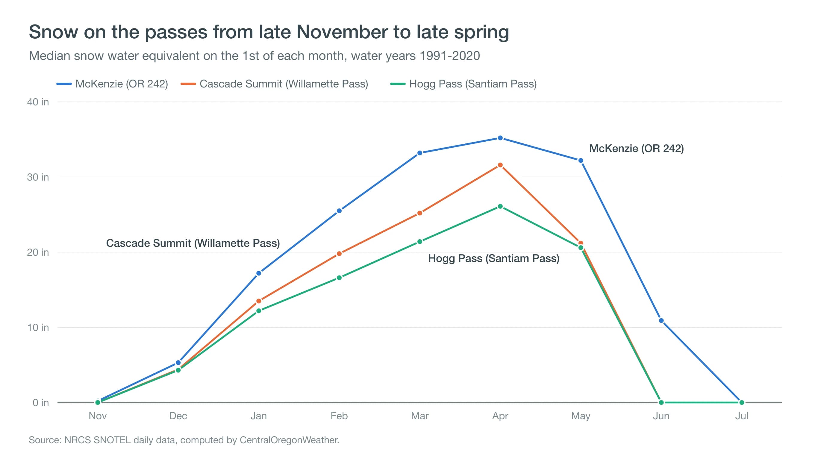
Santiam Pass gets snow from late November into May, and its storms are frequent and wet. The Hogg Pass snow sensor, at 4,800 feet near the summit, typically has a lasting snowpack by Nov. 29 and two feet of snow on the ground by Dec. 1. By April 1, it holds a median of 26 inches of snow water, which at typical spring density is a snowpack about six feet deep.
US 20 runs from Sisters past Suttle Lake and Hoodoo Ski Area to the pass, then down to Santiam Junction, where the co-op weather station at 3,750 feet has averaged close to 190 inches of snow a year (computed from its daily records, which have gaps). Because the pass is about 300 feet lower than Willamette Pass, warm storms can more often bring rain or heavy, wet snow that turns to ice overnight. The Santiam Pass destination page shows the current forecast.
What Is Winter Weather Like on Willamette Pass?
Willamette Pass is the highest of the open routes at 5,128 feet, and its snow is deeper and colder. The Cascade Summit sensor at 5,100 feet usually reaches two feet of snow depth by Nov. 30 and builds to a median 32 inches of snow water by April 1. Nearby, the Odell Lake East station averages about 190 inches of snow a year, nearly nine times Bend's total.
OR 58 connects Oakridge and Eugene with US 97 south of Crescent and is the main route for travelers heading to Bend from the southern Willamette Valley. Its extra height means storms that bring rain to Santiam Pass can still bring snow here, which helps the Willamette Pass ski area but makes for long stretches of snow-covered road. Check the Willamette Pass destination page before crossing.
When Does McKenzie Pass Close and Reopen?
McKenzie Pass closes to vehicles from about early November until at least the third Monday in June. ODOT does not plow OR 242, a narrow, winding highway through lava fields that tops out at 5,325 feet beside the Dee Wright Observatory. In 2025 the east side closed on Nov. 6, and the west side closed earlier.
The snow sensor explains the June opening. At the McKenzie SNOTEL site, the median snowpack still holds 11 inches of water on June 1, and the median melt-out date is June 9. Even after the snow melts, crews need time to clear the road. The McKenzie Pass destination page is the place to check summit weather once the highway opens.
Is the Cascade Lakes Highway Open in Winter?
The Cascade Lakes Highway is plowed from Bend to Mt. Bachelor all winter, but the stretch beyond the ski area closes. Deschutes County gates the highway between the snow gates at Dutchman Flat and Deschutes Bridge, usually in mid to late November, and typically reopens it by Memorial Day, depending on snow.
That high stretch past Todd Lake and Sparks Lake runs at roughly 5,400 to 6,400 feet, where the Irish Taylor sensor's snow usually lasts until late June. Snowmobilers and cross-country skiers use the closed road in winter. For the ski area itself, our guide to when Mt. Bachelor opens covers the season calendar.
Do You Need Chains to Cross the Oregon Cascades in Winter?
You need to carry chains or use traction tires whenever ODOT posts chain requirements, which is common on Santiam and Willamette passes during and after storms. Under Oregon rules, vehicles of 10,000 pounds or less that are not towing may use traction tires instead of chains when chains are required. Heavier vehicles and anything towing must carry and use chains.
In the worst conditions, ODOT can declare a conditional closure, requiring chains on every vehicle regardless of tires or drive. All-wheel drive helps you get moving, but it does not help you stop or steer on ice. The biggest hazard often comes after the storm, when packed snow polishes to ice and melt from the afternoon sun refreezes overnight. Learn how that happens in our guide to black ice, and how sudden squalls can bring whiteouts in what is a snow squall.
How Do You Check Pass Conditions Before You Leave?
Check three things before every winter crossing: the road report, the snow level and the timing of the next storm.
- ODOT TripCheck. Chain requirements, closures, crashes and live cameras for each pass.
- The snow level. If the forecast snow level is below the summit, the pass will see snow. Our snow-level guide explains how to read it.
- National Weather Service alerts. Winter storm warnings and advisories from NWS Pendleton, Portland and Medford cover different parts of the Cascades.
Cross in daylight when you can. Midday road temperatures are usually the warmest of the day, and cameras and snowplows have had time to work. Early morning and night bring the most ice.
Pack for a delay, not just the drive. A winter crossing can stall for an hour or more behind a crash or a chain-up area, so carry warm layers, gloves for handling chains, water, snacks, a flashlight, an ice scraper and a charged phone, and start with a full tank. Cell service can be limited in the mountains, so tell someone your route and expected arrival time.
Deep Dive: How Do Tires Lose Grip on Snow and Ice?
Tires lose grip on snow and ice because the friction between rubber and a frozen surface is a small fraction of the friction on dry pavement. Chains and traction tires exist to win some of it back.
How Slippery Is Ice Compared With Dry Pavement?
Engineers describe grip with a friction coefficient: the share of a car's weight that the tires can turn into braking or steering force. Typical values are about 0.7 to 0.8 on dry asphalt, around 0.2 to 0.3 on packed snow and roughly 0.05 to 0.15 on ice. Braking distance grows as the coefficient shrinks. Using the standard formula, distance equals speed squared divided by twice the friction coefficient times gravity, a car braking from 45 mph needs about 30 meters on dry pavement and about 200 meters on ice, roughly the length of two football fields.
Why Is Ice Near 32°F the Most Dangerous?
Ice is slipperiest close to its melting point. Physicists have long debated exactly why, but the leading explanations agree that a very thin, liquid-like layer forms on the ice surface near 32°F, and the heat of a sliding tire adds a little meltwater of its own. That film acts as a lubricant. Very cold ice, near 0°F, is actually grippier. Pass storms usually hover near freezing, which puts the road right in the worst range.
How Do Chains and Traction Tires Help?
Chains and studs work by biting through the slippery film into the ice beneath. Snow-rated tires use deep, siped tread and rubber that stays soft in the cold; their grooves pack with snow, and snow-on-snow friction is higher than rubber on snow. None of them restore dry-pavement grip, and at highway speeds on glare ice even the best equipment gives only a modest margin. That is why ODOT can require chains on every vehicle when conditions are bad enough.
What Is the Safest Way to Plan a Winter Crossing?
The passes are where Central Oregon's dry side ends, so plan every winter crossing as a trip into a different climate. Carry chains even if you have traction tires, leave extra time, and pick the route and the hour with the best odds. Before you go, check ODOT TripCheck for chain requirements and cameras, and the Central Oregon snow forecast for the snow level and expected totals on Santiam and Willamette passes.