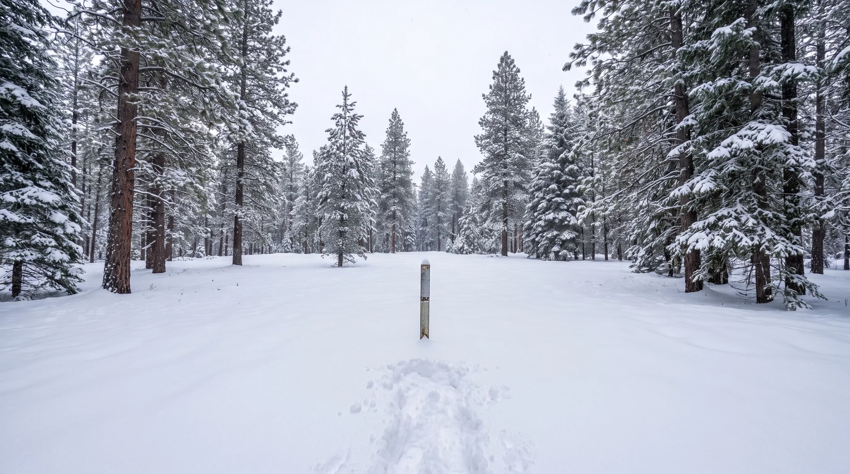
Snow water equivalent is the depth of water you would get if you melted the snowpack, measured in inches. Ten inches of snow may hold one inch of water or much more, depending on how dense it is. In Central Oregon, NRCS SNOTEL sites in the Cascades measure it every day, and the April 1 value is the standard gauge of the summer water supply.
Snow depth tells skiers what they will ride. Snow water equivalent, or SWE, tells everyone else how much water the mountains are holding for summer: for the Deschutes River, for irrigation canals and for reservoirs such as Wickiup. On April 1, 2026, the Hogg Pass sensor near Santiam Pass held just 0.5 inches of snow water against a median of 26.1 inches. This guide follows that water from a sensor in the Cascades, through spring melt, into the river, and ends with how to read the numbers each spring.
What Is Snow Water Equivalent?
Snow water equivalent is the snowpack measured as water. Imagine pressing a tube straight down through the snow to the ground, lifting out the core and melting it: the depth of water in the tube is the SWE. A snowpack 3 feet deep might hold 9 inches of water in midwinter and 13 inches by spring, after it settles and grows denser.
That is why snowpack reports and ski reports can tell different stories. A ski area can show a deep base of settled snow while water managers worry, or fresh fluffy snow can look impressive but add little water. For water supply, only the water counts. Converting snow to water, though, is not a fixed ratio.
How Much Water Is in a Foot of Snow?
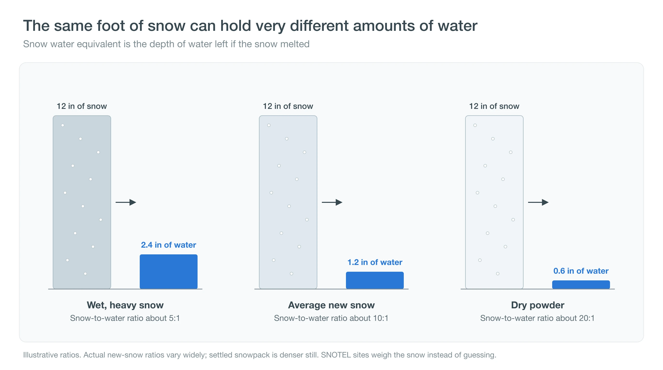
A foot of average new snow holds about 1.2 inches of water, the familiar 10-to-1 rule of thumb. The real ratio swings widely. Wet, heavy Cascade snow, the kind skiers call "Sierra cement," can run about 5 to 1, while cold, dry powder can run 20 to 1 or more.
Snow on the ground also changes after it falls. Its own weight packs it down, and daytime melting followed by nighttime refreezing turns flakes into rounded grains. At the Irish Taylor SNOTEL site southwest of Mt. Bachelor, the snowpack holds a median of about 26% water by volume on December 1 and about 36% by April 1, based on our analysis of its daily depth and SWE records from 2007 to 2025. New snow is often closer to 10%. Instead of guessing ratios, then, the snowpack is weighed.
How Is Snowpack Measured in Central Oregon?
Central Oregon's snowpack is measured by the Natural Resources Conservation Service's SNOTEL network, automated stations that weigh the snow and report SWE, snow depth and temperature every day. Six sites between Santiam Pass and Willamette Pass track the snow that feeds the upper Deschutes and nearby rivers.
| Site | Elevation | Median April 1 SWE | 2015 | 2025 | 2026 |
|---|---|---|---|---|---|
| Three Creeks Meadow | 5,680 ft | 16.9 in | 0% | 99% | 1% |
| Irish Taylor | 5,540 ft | 33.5 in | 27% | 141% | 12% |
| Cascade Summit | 5,100 ft | 31.6 in | 9% | 135% | 14% |
| Hogg Pass | 4,800 ft | 26.1 in | 3% | 93% | 2% |
| McKenzie | 4,770 ft | 35.3 in | 4% | 120% | 4% |
| Salt Creek Falls | 4,220 ft | 18.1 in | 2% | 108% | 1% |
NRCS SNOTEL daily data. Medians are 1991-2020 April 1 values computed by CentralOregonWeather; yearly columns show April 1 SWE as a percent of that median.
April 1 matters because it is usually close to the seasonal peak at these elevations. After that, melt takes over: the snow is typically gone by mid to late May at Salt Creek Falls, Three Creeks Meadow and Hogg Pass, and by about June 23 at Irish Taylor, about 18 miles southwest of Mt. Bachelor. For the storm-by-storm side of the picture, see the Central Oregon snow forecast. The 2026 numbers show what a bad year looks like.
What Happened in Central Oregon's 2026 Snow Drought?
On April 1, 2026, the six SNOTEL sites held between 1% and 14% of their median snow water, the second deep snow drought in a dozen years. In 2015, the previous one, the same sites held between 0% and 27%. A year earlier, in 2025, they had stood near or above normal, at 93% to 141%.
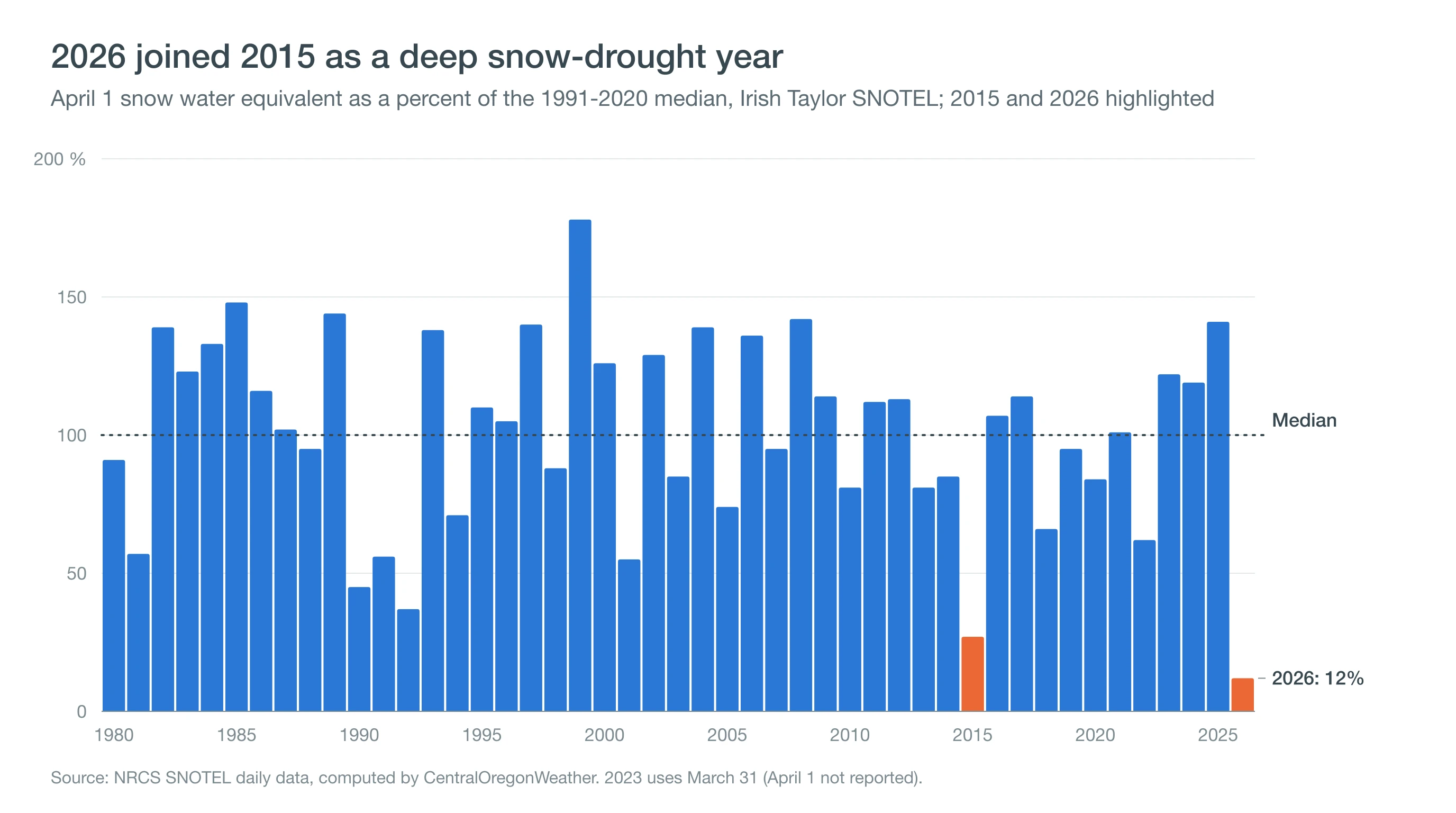
A snow drought is a winter with unusually little water stored as mountain snow. It can come from a lack of storms, or from storms that are warm enough to fall as rain on the high slopes. Either way the effect on summer is similar. The 2026 record also shows how fast a thin snowpack can disappear: Irish Taylor held 11.0 inches of water on March 1 and only 3.9 inches a month later. Our El Niño outlook for Central Oregon covers what the coming winter may bring, and atmospheric rivers explains the storms that build a big snowpack. Where does the missing water show up?
How Does Snowpack Affect the Deschutes River and Wickiup Reservoir?
Snowpack feeds the upper Deschutes through spring and summer, both directly as melt and through the springs and groundwater that the porous volcanic ground stores. Wickiup Reservoir, the largest on the upper river, refills mainly in winter from river flow and is drawn down each summer to supply irrigation districts.
| Year | April 1 | September 30 |
|---|---|---|
| 2015 | 199,100 | 17,200 |
| 2018 | 199,200 | 2,800 |
| 2021 | 115,700 | 3,200 |
| 2025 | 176,800 | 66,800 |
| 2026 | 186,300 | 25,200 |
U.S. Bureau of Reclamation Hydromet, station WIC, rounded to the nearest 100 acre-feet. Wickiup holds about 200,000 acre-feet when full.
In 2026, Wickiup started April nearly full, at about 186,000 acre-feet, because it had refilled over the winter; by the end of September, after the irrigation season, it was down to about 25,000 acre-feet. Through Bend, the river also carries far less in summer than its upstream flow suggests. From 1991 to 2025, July flow averaged about 1,880 cubic feet per second at Benham Falls above Bend, but only about 110 below Bend, after the irrigation canals take their share. See Wickiup Reservoir and Benham Falls conditions, and our guide to floating the Deschutes. Low snow reaches beyond the river.
What Does a Low Snowpack Mean for Summer in Central Oregon?
A low snowpack raises the odds of an early, dry summer, though it does not guarantee one. With less snow to melt, high-country trails open earlier, creeks and streams drop sooner, and soils and forest fuels dry out earlier in the season. That can lengthen the window for wildfires, and with it the smoke season.
The reverse is also true: a big snowpack can delay the start of fire season by keeping the ground moist into July, but it does not prevent summer fires. Read about where Central Oregon's smoke comes from and red flag warnings.
Deep Dive: How Do You Weigh a Snowpack, and What Does It Take to Melt It?
A snowpack is weighed by a pressure sensor under the snow, and melting it takes a large, measurable amount of energy, which is why the same April snowpack can disappear in four weeks one year and ten the next.
How Does a Snow Pillow Work?
A SNOTEL site sits in a forest clearing with a snow pillow on the ground: a large, flat, flexible bladder filled with an antifreeze solution. As snow piles on top, its weight pushes on the fluid, and a pressure transducer converts that pressure into inches of water. Because the sensor weighs the snow, it measures water directly, whatever the snow's density. Errors can creep in when an ice layer "bridges" across the pillow and carries part of the load, so NRCS hydrologists check the data against depth sensors and manual surveys.
Why Is the Snowpack Denser Than New Snow?
New snow is mostly air. Over the winter, each storm's weight compresses the layers below, and sharp-edged crystals round off into grains that pack more tightly. Midwinter rain and sunny thaws add water that refreezes inside the pack. At Irish Taylor, those processes raise the median density from about 26% water on December 1 to about 36% on April 1, and to about 40% by May 1 as melt begins. A pack at that density is close to "ripe," ready to release water as soon as more energy arrives.
Density also explains why snowpack numbers and ski reports can disagree. A 40-inch base at 36% density holds about 14 inches of water, while 40 inches of fresh, 10% powder holds only about 4. The same depth can mean more than three times as much stored water, which is why water managers ignore depth and look only at SWE. Density matters on roofs too: each inch of water in the snow weighs about 5.2 pounds per square foot, which is why heavy, wet snow drives snow loads and ice dams.
How Much Energy Does It Take to Melt It?
Melting ice takes about 334 kilojoules per kilogram. One inch of snow water over a square meter weighs 25.4 kilograms, so melting it takes about 8.5 megajoules per square meter. Irish Taylor's median April 1 snowpack of 33.5 inches therefore needs roughly 285 megajoules per square meter to melt, supplied mostly by spring sunshine, warm air and rain. Clear, warm springs deliver that energy quickly; cool, cloudy ones slowly. That energy budget is why melt-out dates vary by weeks from year to year.
The 2026 record shows that budget at work. Between March 1 and April 1, Irish Taylor's snowpack lost about 7.1 inches of water, roughly 60 megajoules per square meter. Spread over 31 days, that equals a steady net input of about 22 watts per square meter if all of it went to melting, a modest amount for a sunny high-elevation spring. A thin snowpack does not need an unusual heat wave to vanish; ordinary March sunshine and mild air were enough to strip most of it away, and the site melted out on April 8, more than two months ahead of its usual date.
How Should You Read Snowpack Reports Each Spring?
Read snowpack as water stored for summer. Percent of median on April 1 is the headline number; under about 50% signals a lean water year, and the 2015 and 2026 lows show how quickly a thin pack can vanish. NRCS publishes daily SNOTEL data and monthly Oregon water-supply outlooks from January through June. Follow storms on the Central Oregon snow forecast, and see the Central Oregon snow guide for snow in the towns.