Prineville, Oregon has hot, dry summers and cold but relatively snow-light winters. NOAA's 1991-2020 normals for the Prineville station give July highs of 86.9°F, December lows of 23.9°F, 10.3 inches of precipitation and 8.8 inches of snow a year, less than half of Bend's snowfall.
Prineville has a place in Oregon's record book too. On July 29, 1898, the town reached 119°F, a reading that still ties the state's all-time high, according to NOAA's State Climate Extremes Committee. Prineville trades Bend's snow for heat, and every season shows the same trade at a different time of year: milder, drier winters with cold valley mornings, hot summers, and dry, clear nights that are good for stars and hard on gardens.
What Is the Weather Like in Prineville, Oregon?
Prineville is warmer than Bend in every month, by about 2 to 3°F in the afternoon for most of the year and by less than 1°F in midwinter. It gets nearly the same amount of precipitation as Bend, 10.33 inches a year to Bend's 10.62, but far less of it falls as snow.
| Month | Average high | Average low | Precipitation | Snowfall | High vs. Bend |
|---|---|---|---|---|---|
| January | 43.2°F | 25.1°F | 1.06 in | 1.8 in | +0.7°F |
| February | 47.6°F | 26.4°F | 0.80 in | 3.2 in | +1.9°F |
| March | 54.7°F | 29.2°F | 0.91 in | 0.9 in | +3.0°F |
| April | 60.2°F | 33.1°F | 0.76 in | 0.3 in | +2.5°F |
| May | 68.9°F | 40.0°F | 1.38 in | 0 | +2.6°F |
| June | 76.4°F | 44.5°F | 0.85 in | 0 | +2.7°F |
| July | 86.9°F | 49.1°F | 0.40 in | 0 | +3.1°F |
| August | 86.4°F | 47.8°F | 0.36 in | 0 | +3.1°F |
| September | 79.0°F | 41.9°F | 0.31 in | 0 | +3.2°F |
| October | 65.1°F | 34.3°F | 0.95 in | 0 | +2.1°F |
| November | 51.3°F | 28.6°F | 1.22 in | 1.1 in | +2.2°F |
| December | 41.9°F | 23.9°F | 1.33 in | 1.5 in | +0.9°F |
NOAA 1991-2020 normals for the Prineville co-op station (2,876 ft) and the Bend co-op station (3,660 ft), via ACIS. The last column is Prineville's average high minus Bend's.
July is the hottest month, December the coldest, and May the wettest, when spring thunderstorms add to the last Pacific storms. The trade between snow and heat starts with geography.
Why Does Prineville Get Less Snow Than Bend?
Prineville gets less snow than Bend because it sits about 750 feet lower, in the Crooked River valley, and farther from the Cascades. Storms arrive drier after crossing the mountains, and the lower valley is often just warm enough for rain or melting snow when Bend gets snow.
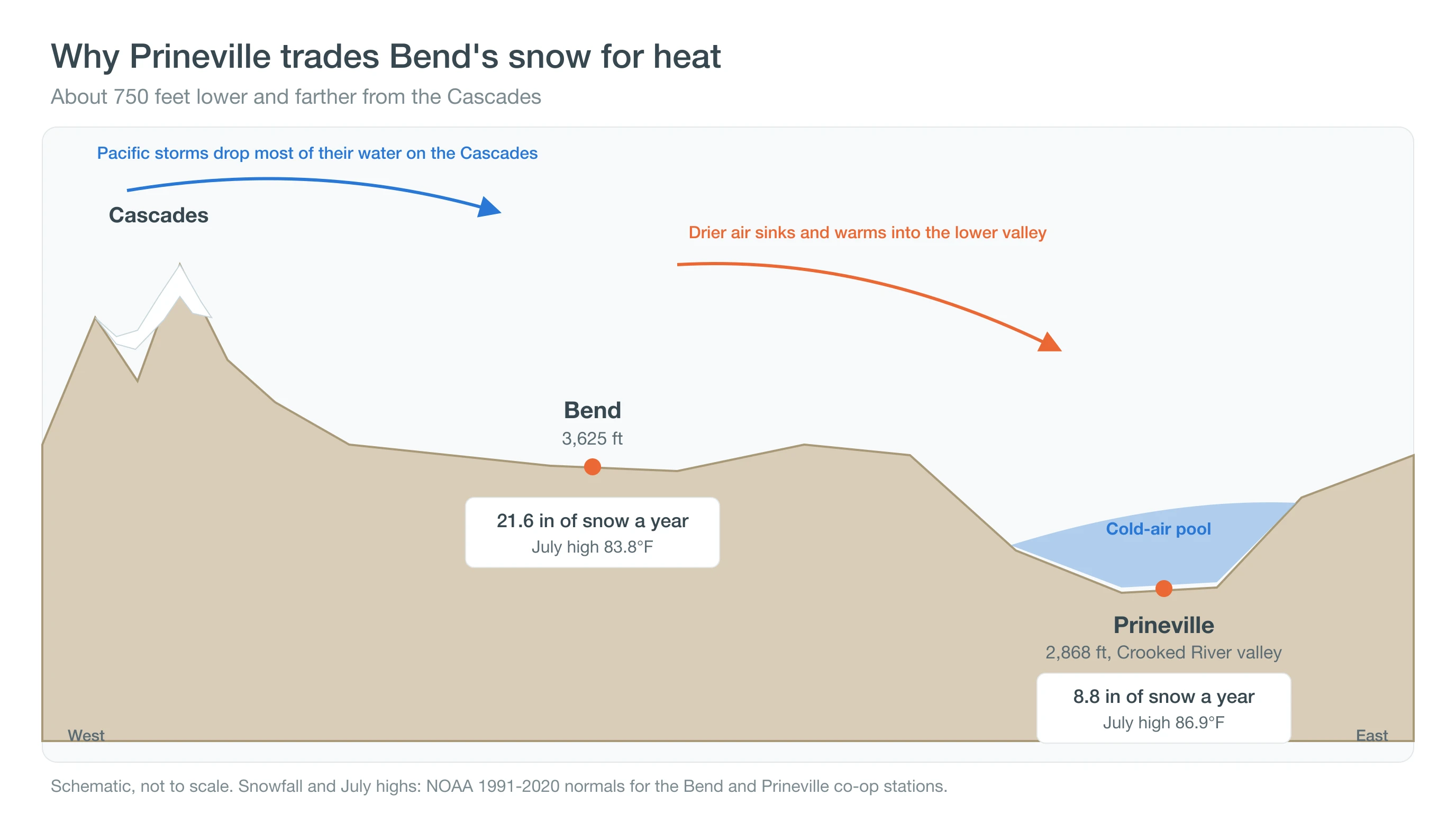
Prineville averages 8.8 inches of snow a year to Bend's 21.6. February is its snowiest month, at 3.2 inches, and no month averages more than that. Snow that does fall usually melts within a few days on the valley floor. Our guides to where it snows in Oregon and Central Oregon elevations show how snow rises with elevation across the region. Less snow does not mean mild nights.
What Are Winters Like in Prineville?
Prineville winters are cold, gray at times and fairly dry. December lows average 23.9°F, and about 26 nights a month fall to freezing or below in December and January, about the same as in Bend. Afternoons usually reach the low 40s.
The valley shape matters most on calm winter nights. Cold, dense air drains off the surrounding hills and the Ochoco foothills and settles on the valley floor, and under a strong high-pressure ridge it can stay there for days, trapping fog, chill and wood smoke under a lid of warmer air. The record low at the Prineville station is -35°F, set on January 21, 1930. Learn more about inversions in Central Oregon.
Prineville is also less snowy than Redmond, its neighbor about 17 miles to the west. Redmond Airport averages about 12.5 inches of snow a year to Prineville's 8.8, though the two weather stations sit less than 200 feet apart in elevation. Prineville's lower, sheltered valley floor is the likely difference, a reminder that local terrain matters as much as height.
Spring arrives earlier here than in Bend. Prineville's April high averages 60.2°F, and the valley sees about 16 frosty nights in April against Bend's 19, giving gardens a slightly earlier start. Then summer turns up the heat.
How Hot Does It Get in Prineville?
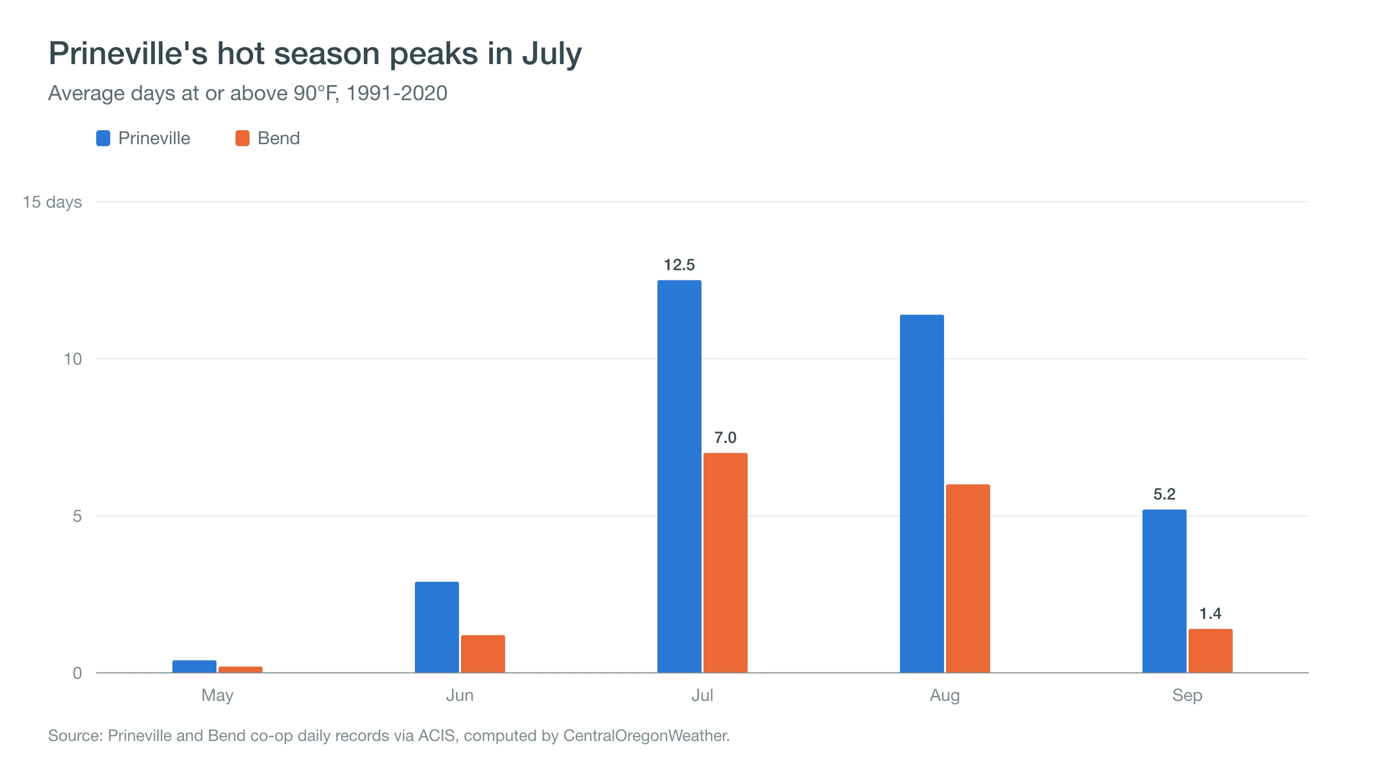
Prineville's July high averages 86.9°F, and the town averages about 12.5 days of 90°F or hotter in July, 11.4 in August and 5.2 in September, about 33 a year. Bend averages about 16.
Prineville's 119°F reading on July 29, 1898, is one of four 119°F readings that share Oregon's all-time record. Pendleton matched it on August 10, 1898, and Pelton Dam, near Madras, and the nearby Moody Farms AgriMet station tied it on June 29, 2021, during the Pacific Northwest heat dome. The Prineville station itself reached 109°F during that 2021 heat wave. See how heat domes trap heat and our guide to Madras and Pelton Dam weather, and see Oregon's weather records. Summer heat also brings some of the clearest nights in the region.
What Is the Weather Like at Prineville Reservoir?
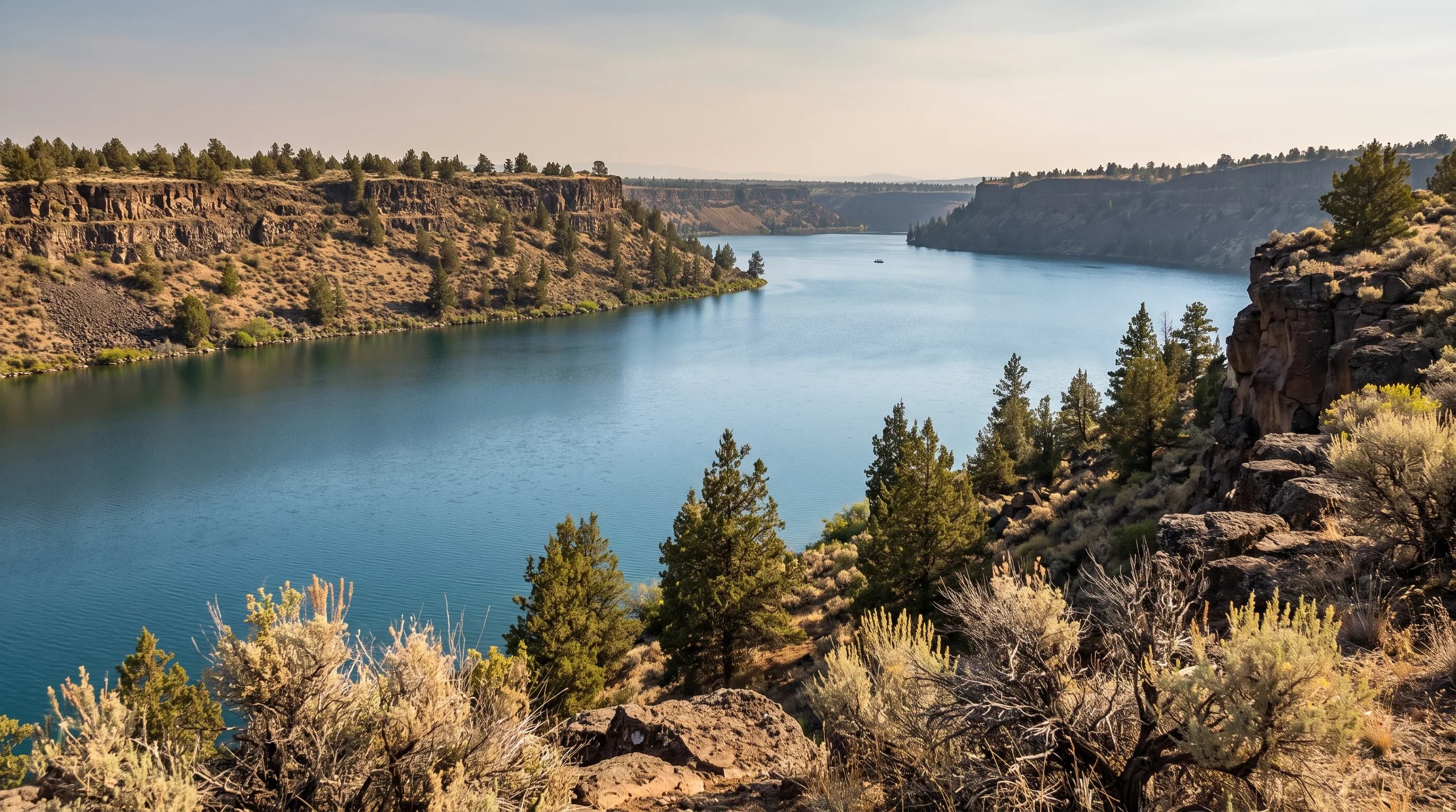
Prineville Reservoir, southeast of town on the Crooked River, shares Prineville's hot, dry summers and adds open water, rimrock and dark skies. Summer days are best for boating and swimming, with highs in the mid to upper 80s, and afternoon breezes can pick up on the water.
The reservoir's nights are its other draw. Prineville Reservoir State Park became Oregon's first International Dark Sky Park in 2021, and it is one of the region's best spots for stargazing. In ERA5 model data for 2011-2025, about 77% of July nights and 71% of August nights there were mostly clear, with average cloud cover of 20% or less, compared with only about 15 to 17% of nights from December through February. Check Prineville Reservoir State Park conditions before a camping trip.
Summer thunderstorms are the main hazard on the water. Storms build over the Ochoco Mountains on some July and August afternoons and can drift over the reservoir with lightning and sudden wind. When you hear thunder, get off the water and away from the shoreline. Our guide to lightning safety on Central Oregon lakes and trails covers what to do.
When Is the Best Time to Visit Prineville?
May, June and September are the best months to visit Prineville for weather. Highs run from the upper 60s to the upper 70s, nights are cool, and smoke is less likely than in August.
- Hiking in the Ochocos: late May through June, when trails at Steins Pillar and the Mill Creek Wilderness have dried out but afternoons are not yet hot.
- Reservoir days: July and August for warm water and long days, with an eye on afternoon storms and smoke.
- Winter sunshine: December through February, when Prineville often has bare ground while Bend and the mountains hold snow.
- Fall color: October, when highs average about 65°F and the cottonwoods along the Crooked River turn, though frost forms on about 17 nights.
In August and early September, check the Central Oregon smoke forecast before planning outdoor days.
Deep Dive: Why Does Prineville Get Nearly as Much Water but Far Less Snow?
Prineville gets nearly as much winter water as Bend but far less snow because its storms arrive a few degrees warmer, often right at the line between rain and snow.
Is Prineville Really Drier Than Bend?
Barely, over a full year: 10.33 inches against Bend's 10.62. The difference is in winter. From December through February, Prineville's normals add up to 3.19 inches of precipitation and 6.5 inches of snow, while Bend gets 4.47 inches of precipitation and 17.2 inches of snow. Prineville makes up some of the gap with a wetter May and October.
How Much Snow Does Each Inch of Winter Water Make?
Dividing winter snowfall by winter precipitation gives a rough ratio of how much of each storm falls as snow. In Bend, each inch of December-February precipitation comes with about 3.8 inches of snow. In Prineville, it comes with about 2.0. Fresh snow is often around 10 inches per inch of water, so both towns get much of their winter precipitation as rain or mixed precipitation, but Prineville gets roughly half as much snow per inch.
The ratio also changes through the winter. In December, Prineville's 1.33 inches of precipitation come with only 1.5 inches of snow, close to one to one, a sign that many early-winter storms there fall as rain. By February, when the air is colder, 0.80 inches of precipitation bring 3.2 inches of snow, about four to one. Bend follows the same pattern at a higher level, from about 2.6 to one in December to about 5.6 to one in February.
Why Is the Split So Different Only 30 Miles Apart?
The Prineville station sits about 780 feet below the Bend station. In the saturated air of a winter storm, temperature falls with height at roughly 3°F per 1,000 feet, so Prineville is typically 2 to 3°F warmer during storms. In Central Oregon, many storms put the snow level near town elevations, and a few degrees decides whether snow sticks or melts. Air descending from the Cascades and the high plateau west of town also warms by compression as it sinks into the Crooked River valley, adding a little more warmth. That combination turns Bend's snow days into Prineville's wet days.
The same margin shows in the other direction in summer. Prineville averages about 33 days of 90°F or hotter a year against Bend's 16, and its July high runs 3.1°F warmer. A difference of a few degrees, applied every day, adds up to a different climate: more rain than snow in winter, more heat in summer, and a growing season that starts a little earlier in spring.
How Should You Plan Around Prineville's Weather?
Plan for Prineville's trade: less snow to shovel and drive on, more summer heat, cold valley mornings in winter and dark, clear summer nights. Check today's conditions on the Prineville destination page, compare with Redmond's weather by month, and watch the smoke forecast in August and September.