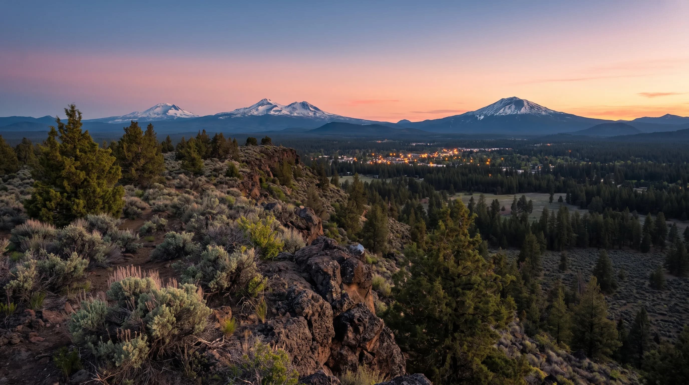
Bend, Oregon sits at about 3,623 feet above sea level, measured downtown. That is moderate altitude: most people notice the dry air and strong sun rather than altitude sickness. The elevation gives Bend about 22 inches of snow a year, July nights near 49°F after 84°F afternoons, and water that boils at about 205°F.
Bend is about 3,600 feet higher than Portland, and NOAA's 1991-2020 normals show what that buys: 21.6 inches of snow a year to Portland's 4.2. In Central Oregon, a few hundred feet of elevation changes the weather you live with. This guide climbs from the town table and what altitude does to your body and your kitchen, to what it does to nights and snow, to the summits of Mt. Bachelor and South Sister.
What Is the Elevation of Bend, Oregon?
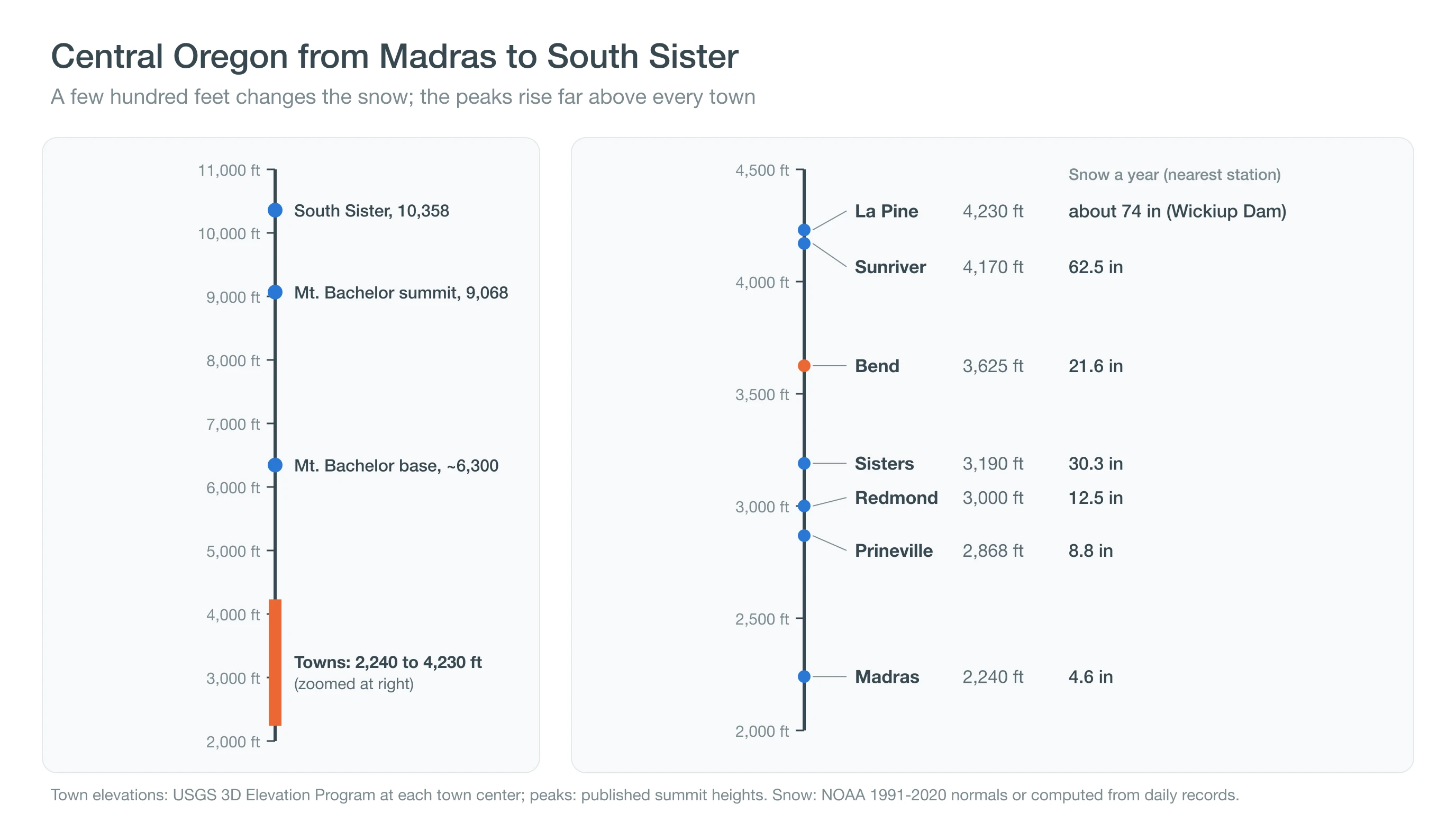
Bend's elevation is about 3,623 feet (1,104 meters), the figure most references give for downtown, and USGS elevation data put the ground at 3,625 feet in the downtown core. The city is not flat, though. The east side sits a little under 3,600 feet, while Awbrey Butte and the west-side hills rise above 3,900 feet.
That spread explains why sources list different elevations for the same town. A city's official figure usually marks one reference point, often near the historic center, while a weather station, an airport or a neighborhood can sit hundreds of feet higher or lower. The Bend weather station, for example, sits at 3,660 feet, and Redmond Airport's station at 3,049 feet. When you compare weather between towns, the station elevations are the ones that matter.
| Place | Elevation | Meters | What it means |
|---|---|---|---|
| Madras | 2,240 ft | 683 m | Lowest larger town; about 5 in of snow a year |
| Prineville | 2,868 ft | 874 m | Crooked River valley; about 9 in of snow |
| Terrebonne | 2,870 ft | 875 m | Gateway to Smith Rock; hot summer afternoons |
| Redmond | 3,000 ft | 914 m | Airport town; about 12 in of snow |
| Tumalo | 3,180 ft | 969 m | Between Bend and Sisters on the Deschutes |
| Sisters | 3,190 ft | 972 m | Near the Cascades; about 30 in of snow |
| Bend (downtown) | 3,623 ft | 1,104 m | About 22 in of snow; cold nights |
| Sunriver | 4,170 ft | 1,271 m | Snow on the ground most of winter |
| La Pine | 4,230 ft | 1,289 m | Cold-air basin; among the coldest nights |
| Mt. Bachelor base | About 6,300 ft | 1,920 m | Ski area base; deep winter snowpack |
| Mt. Bachelor summit | 9,068 ft | 2,764 m | Above treeline; wind and rime ice |
| South Sister summit | 10,358 ft | 3,157 m | Highest of the Three Sisters |
Town elevations are USGS 3D Elevation Program ground heights at each town center, rounded to the nearest 10 feet, except the commonly cited figures for Bend (3,623 ft), Madras (about 2,240 ft) and Prineville (2,868 ft). Peak heights are published summit elevations. Snow notes are NOAA 1991-2020 normals or values computed from nearby station records.
Every larger town in Central Oregon sits between about 2,200 and 4,300 feet, a 2,000-foot range that holds a surprising spread of climates, from the canyon heat below Madras to La Pine's deep snow. Each town has its own month-by-month guide, including Redmond, Sisters and Prineville. The table raises the question visitors ask first.
Is Bend Considered High Altitude?
Bend counts as high altitude for cooking but not for altitude sickness. Most cookbooks and food-safety guides treat 3,000 feet and above as high altitude for recipes, and Bend is above that line. Medical guidance sets a much higher bar: the CDC notes that unacclimatized travelers sleeping at 8,000 feet or higher are at risk of altitude illness, and Bend is less than half that height.
What visitors do notice is the dry air and the strong sun. Lips and skin dry out quickly, people get thirsty faster on hikes, and sunburn comes sooner than at sea level. Mt. Bachelor's summit, at 9,068 feet, is a different story, and some people feel the thinner air there on a hard ski or hike. For health questions at any elevation, follow the CDC's high-altitude travel guidance and talk with a doctor. The first place most visitors notice Bend's elevation is the kitchen.
Do You Need to Adjust Cooking and Baking at Bend's Elevation?
Yes, a little. Water boils at about 205°F in Bend instead of 212°F at sea level, because the boiling point drops by just under 1°F for every 500 feet of elevation, according to USDA food-safety guidance.
- Boiled and simmered foods: pasta, beans, rice and eggs take a little longer, because the water is cooler even at a full boil.
- Baking: university extension high-altitude guides, such as Colorado State University's, suggest small changes from about 3,000 feet up, such as slightly less leavening and sugar, a little more liquid and sometimes a hotter oven. Test one change at a time.
- Food safety: cook meat to the same safe internal temperatures as anywhere else, checked with a thermometer.
The bigger effect of Bend's elevation is outdoors, in the weather.
How Does Elevation Change Central Oregon's Weather?
Elevation makes Central Oregon colder on average, snowier and quicker to cool at night. Air thins and cools with height, and thin, dry air holds heat poorly after sunset. Bend's July average high is 83.8°F and its July average low is 48.6°F, a 35-degree swing. Portland's July swing is about 23 degrees, from 81.9°F to 58.5°F.
Elevation is not the whole story, though. Distance from the Cascades and the shape of the land matter too. Madras is the lowest town but has colder December nights than Bend, because cold air settles on its open plateau, and Sisters gets more snow than Bend despite sitting lower, because it is closer to the mountains. Our guide to why Central Oregon has such big day-to-night swings explains the nightly cooling in detail. The clearest elevation signal is snow.
Why Do Higher Central Oregon Towns Get More Snow?
Higher towns get more snow because more storms arrive with the snow level below them, and snow that falls there melts more slowly. Average yearly snowfall climbs from about 5 inches at Madras to about 22 in Bend and about 74 at Wickiup Dam, near La Pine.
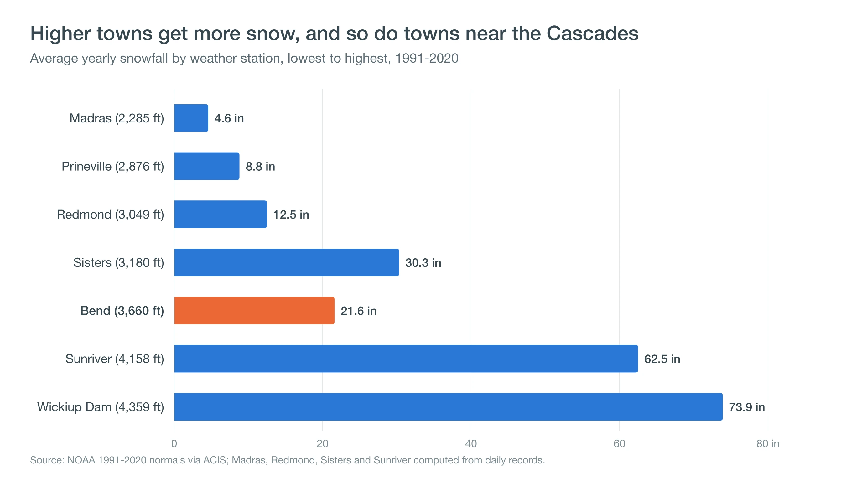
Many winter storms bring a snow level close to Central Oregon's town elevations, so a few hundred feet decides whether a town gets rain, slush or a snow day. Read the snow level map guide and why it can rain in Bend but snow at Mt. Bachelor. The top of the climb shows the effect at its extreme.
How High Are Mt. Bachelor and the Three Sisters?
Mt. Bachelor's summit stands at 9,068 feet, about 5,400 feet above downtown Bend, and the ski area base sits near 6,300 feet. South Sister is the tallest of the Three Sisters at 10,358 feet, with North Sister at 10,085 feet and Middle Sister at 10,047 feet.
That extra height brings a different climate. At the standard rate of about 3.6°F per 1,000 feet, Mt. Bachelor's summit runs roughly 20°F colder than Bend on a typical day, and it catches far more of each Pacific storm. Wind, rime ice and whiteouts are routine above treeline in winter. See Mt. Bachelor weather from base to summit and when Mt. Bachelor opens.
Deep Dive: What Does Thinner Air Actually Change at 3,600 Feet?
Thinner air at 3,600 feet changes three things: how much air you breathe, how hot water can get before it boils, and how much sunlight and heat pass through the atmosphere above you.
How Much Less Air Is Above Bend?
The U.S. Standard Atmosphere puts average air pressure at Bend's 3,623 feet at about 887 hectopascals, roughly 88% of sea-level pressure, or about 12.9 pounds per square inch against 14.7. Each breath therefore holds about 12% fewer air molecules than at the coast. At Mt. Bachelor's summit, pressure falls to about 722 hectopascals, about 71% of sea level. Both values come from the standard barometric formula and vary a little with the weather.
The same formula gives a handy rule of thumb: in the lower atmosphere, pressure falls by roughly 1 hectopascal for every 30 feet of climb. Driving from Madras at about 2,240 feet to Bend at 3,625 feet drops the pressure by about 46 hectopascals, roughly the swing between a strong storm and a strong high-pressure ridge at sea level. That is why weather stations report pressure adjusted to sea level, so readings from different elevations can be compared.
Why Does Water Boil Cooler?
Water boils when its vapor pressure equals the pressure of the air above it. At about 887 hectopascals, that happens near 205.4°F, and at Mt. Bachelor's summit near 195.5°F. The relationship between temperature and vapor pressure, described by the Clausius-Clapeyron equation, works out to just under 1°F lower for each 500 feet near Central Oregon's elevations. Cooler boiling water cooks food more slowly and lets batters rise faster, which is why extension services publish high-altitude adjustments from about 3,000 feet up.
Across Central Oregon, the boiling point tracks the town table. Water boils near 207.9°F in Madras, about 205.4°F in Bend, 204.3°F in La Pine, about 200.5°F at Mt. Bachelor's base area and about 193°F on the summit of South Sister. Pressure-cooker manufacturers and extension services publish altitude adjustments for exactly this reason, because the temperature inside the pot, not the bubbling, decides how fast food cooks.
Why Does Thin, Dry Air Mean Strong Sun and Cold Nights?
Less air and less water vapor above you absorb less ultraviolet light on the way down and trap less infrared heat on the way up. The World Health Organization estimates that UV levels rise about 10% for every 1,000 meters of elevation, which puts Bend roughly 11% above sea level and Mt. Bachelor's summit roughly 28% higher, all else being equal. At night, the same thin, dry column lets the ground radiate heat to space quickly, which is how Bend's July afternoons near 84°F fall to about 49°F by dawn. Our Bend UV index guide covers the sunburn side.
What Does Elevation Mean for Your Plans?
In Central Oregon, elevation decides whether you get rain or snow, mild or frigid nights, and how fast you burn. Know your town's height, pack for a wide day-to-night swing, and expect snow to climb with every few hundred feet. Compare current conditions by elevation on the CentralOregonWeather 3D map, and check town forecasts for Bend, Sunriver and Mt. Bachelor before a trip.