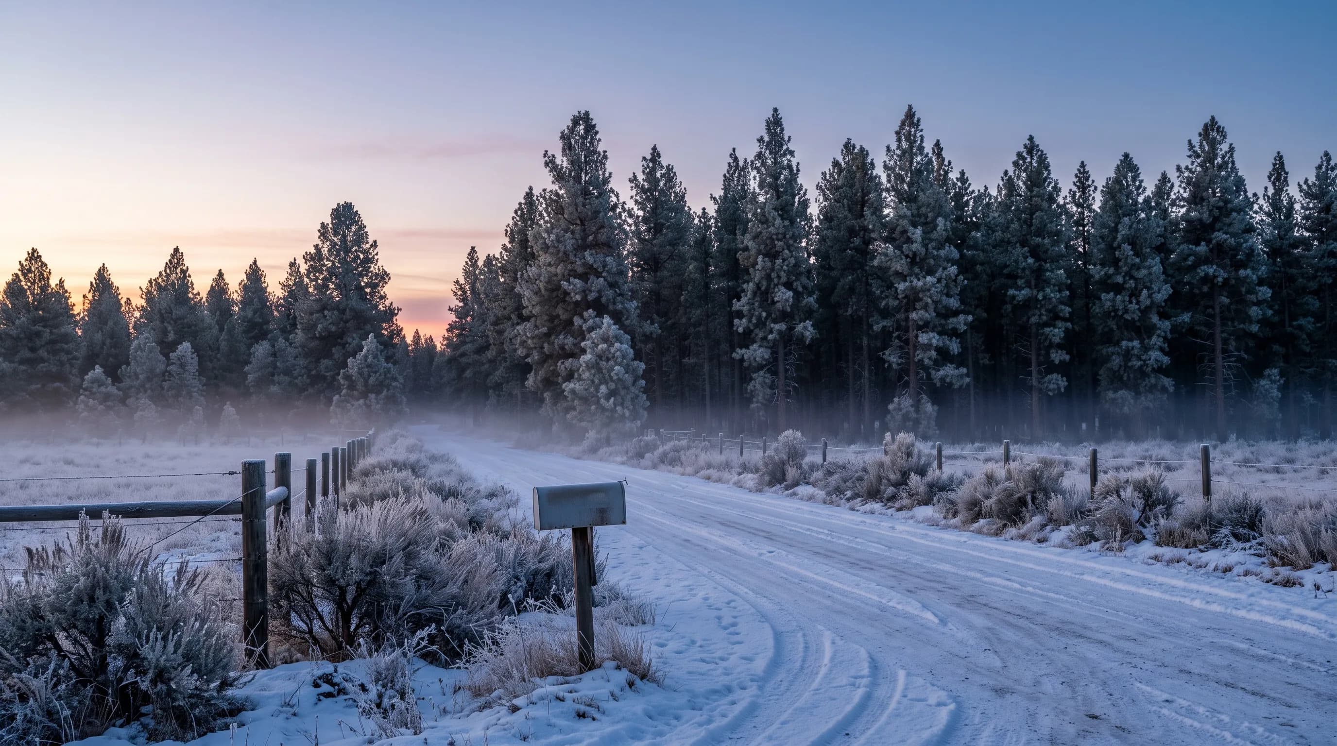
La Pine, Oregon has cold, snowy winters and warm, dry summers. The town sits at about 4,230 feet. Wickiup Dam, the nearest long-record weather station, averages 73.9 inches of snow a year and December lows near 21°F, while July highs reach 82.5°F (NOAA 1991-2020). La Pine has no official NOAA climate station of its own.
La Pine sits about 600 feet higher than downtown Bend, in a broad, flat, forested basin along the upper Deschutes River, and that basin is the key to its weather. On clear, calm nights, cold air drains off the surrounding slopes and settles there, so winters run colder and snow lasts far longer than in Bend, while summer days still reach the low 80s. Each season below shows the basin at work.
What Is the Weather Like in La Pine, Oregon?
La Pine has a true four-season mountain climate. Winters bring frequent snow and long stretches of snow on the ground, springs arrive late, summers are warm and dry with cool nights, and falls turn cold quickly. Because La Pine has no NOAA station, this guide uses Wickiup Dam, about 9 miles west at 4,359 feet, and Sunriver, about 14 miles north at 4,158 feet. Both sit in the same upper Deschutes basin.
| Month | Average high | Average low | Precipitation | Snowfall | Days with snow on the ground |
|---|---|---|---|---|---|
| January | 39.7°F | 21.1°F | 2.97 in | 17.9 in | 26.3 |
| February | 43.1°F | 21.9°F | 2.04 in | 14.9 in | 21.3 |
| March | 48.1°F | 25.7°F | 1.72 in | 8.4 in | 15.8 |
| April | 53.8°F | 29.8°F | 1.25 in | 2.0 in | 3.2 |
| May | 63.4°F | 36.3°F | 1.32 in | 0.3 in | 0.2 |
| June | 71.2°F | 41.8°F | 0.90 in | 0 | 0 |
| July | 82.5°F | 47.3°F | 0.45 in | 0 | 0 |
| August | 82.4°F | 45.6°F | 0.59 in | 0 | 0 |
| September | 75.3°F | 38.4°F | 0.61 in | 0 | 0 |
| October | 61.8°F | 31.3°F | 1.45 in | 0.8 in | 0.6 |
| November | 46.3°F | 26.2°F | 2.60 in | 8.9 in | 8.4 |
| December | 38.1°F | 20.9°F | 3.62 in | 20.7 in | 21.2 |
La Pine has no official NOAA climate station. Highs, lows, precipitation and snowfall are NOAA 1991-2020 normals for Wickiup Dam (4,359 ft), about 9 miles west of La Pine. Days with 1 inch or more of snow on the ground are computed by CentralOregonWeather from the station's daily records, 1991-2020.
December is the coldest, wettest and snowiest month, and July and August tie as the warmest. In all, the Wickiup station averages about 97 days a year with snow on the ground. The basin is the reason La Pine runs colder than Bend.
Why Is La Pine Colder Than Bend?
La Pine is colder than Bend for two reasons: it sits about 600 feet higher, and its flat basin collects cold air that drains down from the Cascades to the west and Newberry Volcano to the east on clear, calm nights.
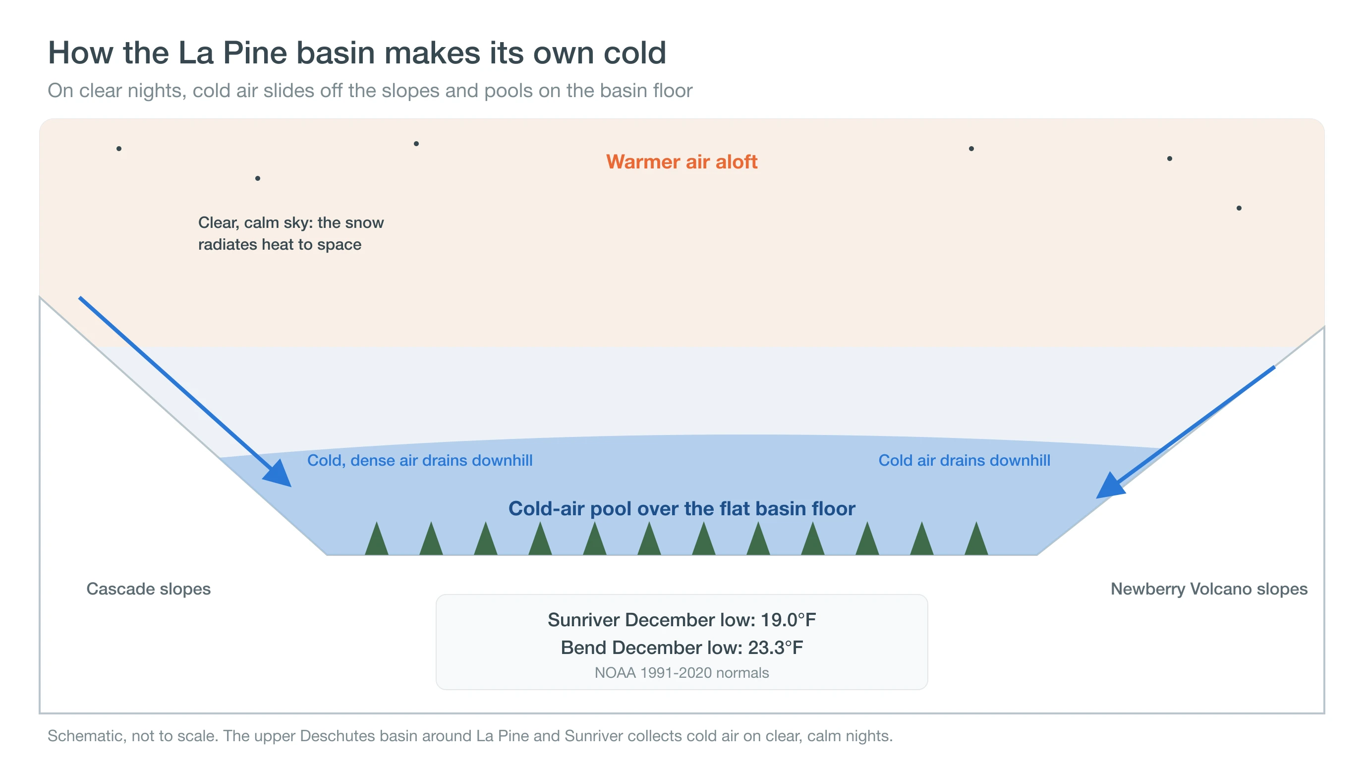
The nights show it most. Sunriver, on the basin floor about 14 miles north of La Pine, averages a December low of 19.0°F against Bend's 23.3°F, and about 4 to 5 mornings a year at 0°F or below, more than twice Bend's count. Frost forms at Sunriver on about 230 nights a year, including a night or two in July. See how inversions trap cold air and why the high desert swings so far between day and night. That cold air keeps snow around.
How Much Snow Does La Pine Get?
The La Pine area gets roughly 60 to 75 inches of snow a year, about three times Bend's 21.6. Wickiup Dam averages 73.9 inches, with 20.7 in December and 17.9 in January, and Sunriver averages about 62 inches, computed from its daily records.
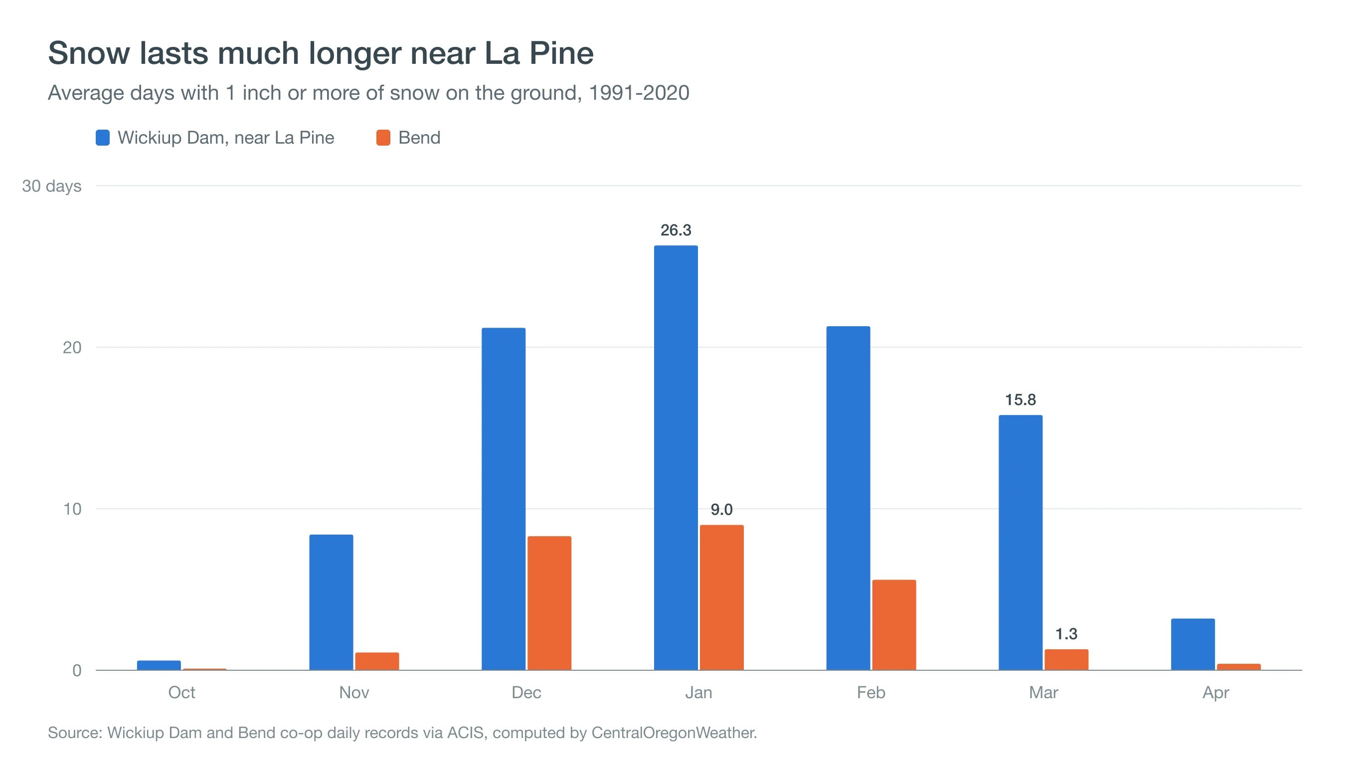
Snow also lasts. Snow covers the ground at Wickiup Dam on an average of 26 days in January, 21 in December and February, and 16 in March, compared with 9 days in Bend's snowiest month. The deepest snow in the Wickiup record was 52 inches on February 22, 1993, and the January 2017 storms left 44 inches on the ground at Sunriver. Winters vary widely, and in a snow-drought winter such as 2025-26, the basin can see far less. The mountain snowpack, measured as snow water equivalent, also feeds Wickiup Reservoir just west of town. Our guide to where it snows in Oregon puts La Pine in statewide context. Snow is only half of a La Pine winter.
What Are Winters Like in La Pine?
La Pine winters are long, cold and snowy. Nights average near 20°F from December through February, 27 to 29 nights a month drop to freezing or below, and a few mornings each winter fall below 0°F. Wickiup Dam's record low is -40°F, set on January 31, 1950.
Winter in La Pine is about preparation as much as weather:
- Roads: US 97 through La Pine sees snow, freezing fog and black ice on cold mornings. Use traction tires and check ODOT TripCheck before driving. Read about black ice and freezing fog.
- Homes: long subfreezing stretches put pipes, wells and roofs to the test. Deep, lasting snow and cold nights are the conditions that build ice dams and heavy snow loads.
- The coldest mornings: clear, calm nights after fresh snow bring the deepest cold and sometimes ice fog and diamond dust. See ice fog and diamond dust in Central Oregon.
Spring arrives late.
When Does Spring Arrive in La Pine?
Spring comes slowly to La Pine. Snow covers the ground at Wickiup Dam on about 16 days in an average March, and frost still forms on about 23 nights in April and 10 in May. Afternoons warm into the mid 50s in April and the low 60s in May, so snowmelt, mud and sunny afternoons can share the same week.
Gardeners in the basin plan for a short season. At Sunriver, frost has formed on an average of 7 nights in June and 15 in September, so cold-tender plants usually go out late and come in early. The payoff is summer.
What Is Summer Like in La Pine?
Summer in La Pine is warm, dry and sunny, with highs averaging 82.5°F in July and 82.4°F in August and nights in the mid 40s. Wickiup Dam averages about 6 days of 90°F or hotter in July and 5 in August, and the June 2021 heat dome pushed the station to 106°F.
Summer is the season for the lakes and the Newberry National Volcanic Monument, including Lava River Cave, which stays near 42°F all year. Paulina and East Lakes sit inside Newberry Crater at more than 6,000 feet, where it runs cooler than town. Afternoon thunderstorms and wildfire smoke are the main summer hazards, so check the Central Oregon smoke forecast and the forecast for Paulina Lake before a trip.
Pack for cold even in summer. Summer nights in the basin average in the mid 40s, and frost has formed at Sunriver on a night or two in July and about three in August, so campers at La Pine State Park and the lakes should bring warm sleeping bags. Fall comes early: October highs average 61.8°F with lows of 31.3°F, and November brings about 9 inches of snow and the start of the snow-cover season.
Deep Dive: How Does a Flat Basin Make Its Own Cold?
A flat basin makes its own cold by losing heat to a clear sky, collecting the cold air that slides off surrounding slopes, and holding it in place until wind or a storm stirs it out.
How Fast Does the Ground Lose Heat on a Clear Night?
Snow is nearly a perfect emitter of infrared heat, with an emissivity of about 0.98 to 0.99. Under a clear, dry winter sky, which sends back little infrared energy of its own, a snow surface can lose on the order of 50 to 100 watts per square meter more than it receives. Fresh snow is also an excellent insulator, so heat stored in the soil below cannot rise fast enough to replace what the surface loses. The surface cools sharply, and the air touching it cools with it.
Where Does the Cold Air Go?
Cold air is denser than the air around it, so it flows downhill like water, a gentle current that meteorologists call drainage or katabatic wind, typically moving a few miles per hour. Across the upper Deschutes basin, that air flows off the Cascade slopes to the west and the flanks of Newberry Volcano to the east and collects in the lowest, flattest ground. The forested floor around La Pine and Sunriver is that ground, and a lid of warmer air above keeps the pool in place until morning sun or a storm mixes it out.
Where the pool sits matters more than elevation. Wickiup Dam, about 200 feet higher than the Sunriver station, averages a December low of 20.9°F, almost 2°F milder than Sunriver's 19.0°F. Wickiup sits on the basin's western edge beside a large reservoir, while Sunriver sits on the flat floor where drainage flows converge. Sunriver records about 230 nights a year at or below freezing, against about 200 at Wickiup.
How Much Colder Is It Than Elevation Alone Predicts?
The Sunriver station sits about 500 feet above the Bend station. If air simply cooled with height at the standard rate of 3.6°F per 1,000 feet, Sunriver's nights would run about 1.8°F colder than Bend's. Instead, December lows average 19.0°F at Sunriver and 23.3°F in Bend, 4.3°F colder, and Sunriver averages 2.0 subzero December mornings to Bend's 0.8. The extra cold is the pool.
Snow cover makes the effect stronger and keeps it going. Once snow covers the basin, which happens on about 26 days of an average January at Wickiup Dam and 26 at Sunriver, the ground no longer supplies much heat at night, so a run of clear nights can grow colder and colder. Breaking that cycle usually takes a storm or a warm, windy day strong enough to mix the pool out of the basin.
How Should You Plan Around La Pine's Weather?
Plan for the basin: deep, lasting snow and some of Central Oregon's coldest nights from November to March, and short, warm, dry summers for the lakes. Check today's forecast on the La Pine destination page, compare with Sunriver's weather by month, and check the Central Oregon snow forecast before winter drives on US 97.