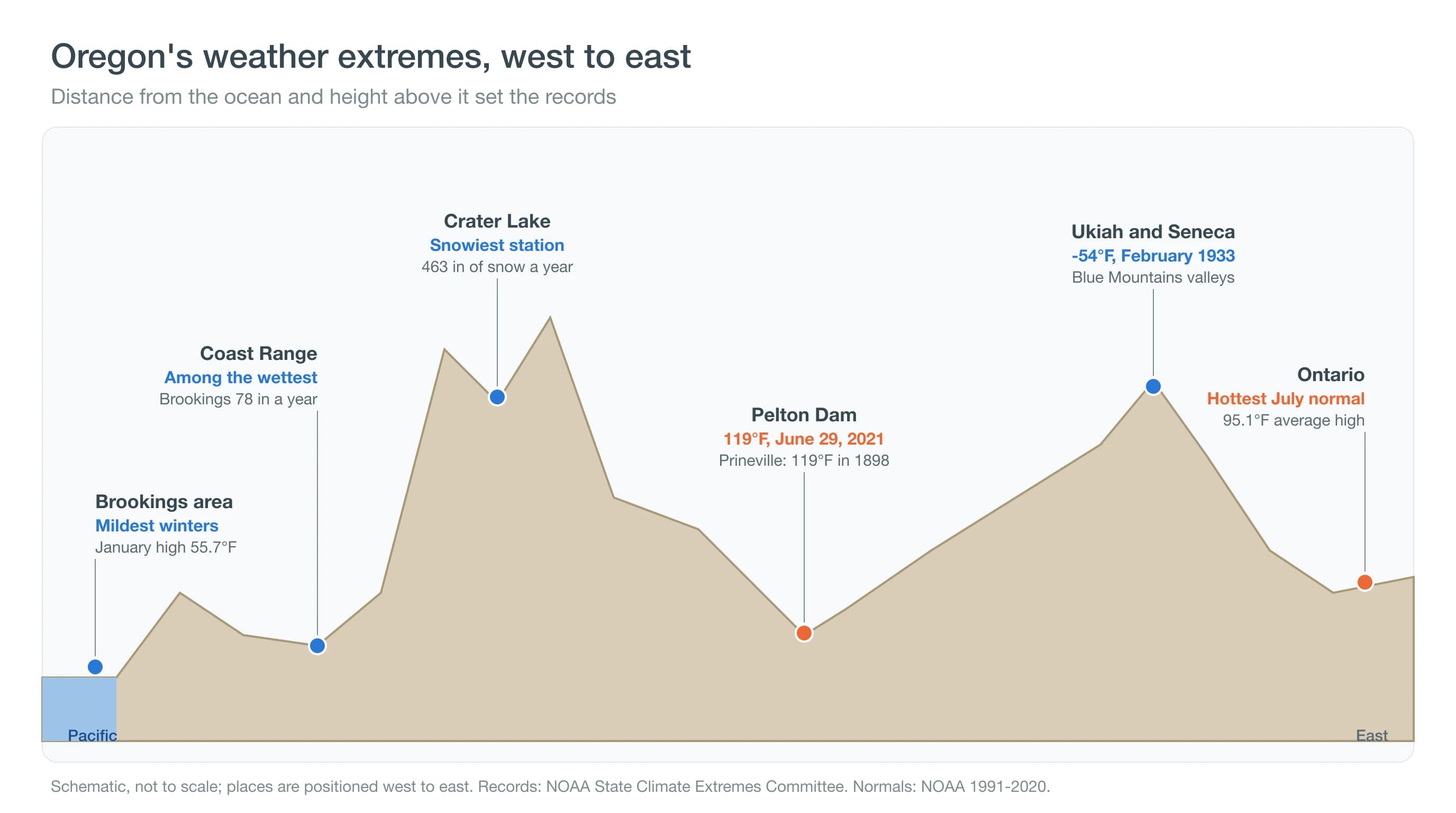
Oregon's hottest recorded temperature is 119°F, reached at Prineville on July 29, 1898, at Pendleton on August 10, 1898, and at Pelton Dam and the nearby Moody Farms station near Madras on June 29, 2021. The coldest is -54°F, at Ukiah on February 9 and Seneca on February 10, 1933. Both records are certified by NOAA's State Climate Extremes Committee.
Three of the four 119°F readings came from Central Oregon: Prineville in 1898, and Pelton Dam and the Moody Farms AgriMet station, both along the Deschutes near Madras, during the 2021 heat dome. Oregon's extremes are a map of distance from the ocean and height above it. This guide moves across that map, from the coast's mild winters, over the soaked Coast Range and snowy Cascades, into Central Oregon's canyons where the heat record sits, and out to the frigid eastern valleys.
What Is the Hottest Temperature Ever Recorded in Oregon?
The hottest temperature ever recorded in Oregon is 119°F, a mark reached on three dates. In February 2022, NOAA's State Climate Extremes Committee confirmed that Pelton Dam and the Moody Farms AgriMet station had both tied the record on June 29, 2021, matching the 1898 readings at Prineville and Pendleton.
| Record | Value | Place | Date |
|---|---|---|---|
| Highest temperature | 119°F | Prineville | July 29, 1898 |
| Highest temperature (tie) | 119°F | Pendleton | August 10, 1898 |
| Highest temperature (tie) | 119°F | Pelton Dam and Moody Farms | June 29, 2021 |
| Lowest temperature | -54°F | Ukiah | February 9, 1933 |
| Lowest temperature (tie) | -54°F | Seneca | February 10, 1933 |
Certified by NOAA's State Climate Extremes Committee. Pelton Dam and the Moody Farms AgriMet station both sit along the Deschutes River in Jefferson County, about 13 miles apart.
Records like these are rare and carefully checked. A committee of climatologists reviews the instrument, its siting and the surrounding observations before a reading enters the record book. Why did Central Oregon produce three of the four?
Why Did Central Oregon Set Oregon's Heat Record?
Central Oregon set the heat record because its deepest canyons combine low elevation, dry air and shelter from the wind on the dry side of the Cascades. Pelton Dam sits at 1,484 feet in the Deschutes canyon, about 800 feet below Madras, and averages a July high of 91.9°F, the hottest of any Central Oregon station.
In late June 2021, an exceptionally strong ridge of high pressure, a heat dome, parked over the Pacific Northwest. Sinking air under it warmed as it was compressed, skies stayed clear and the heat built day after day. In Central Oregon, Redmond Airport reached 112°F on June 29, and the Bend station hit 107°F, both the hottest readings in their records. Our guides to heat domes, Redmond weather, Madras and Pelton Dam weather and Prineville weather cover the local story. But the record is not the same as the hottest everyday summers.
Where Are Oregon's Hottest Summers?
Among stations with 1991-2020 normals that we compared, Ontario, near the Idaho line, has the hottest summers, with a July average high of 95.1°F. Rome, in the southeast high desert, follows at 93.9°F, then Hermiston in the Columbia Basin at 92.7°F, Pelton Dam at 91.9°F and Medford at 91.6°F.
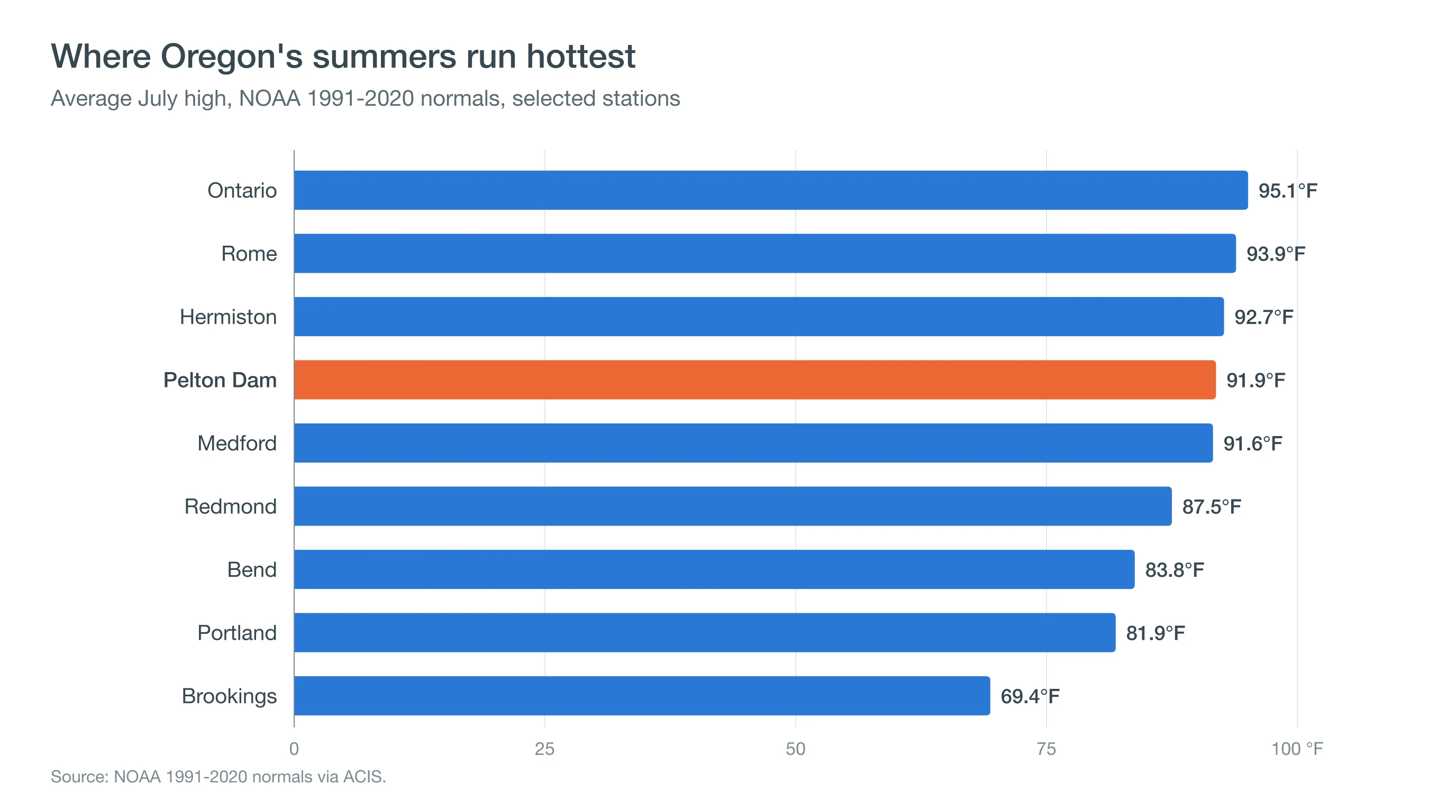
The pattern follows the map: the lowest valleys far from the ocean run hottest, while the coast stays mild. July is usually slightly hotter than August in most of Oregon; Bend averages 83.8°F in July and 83.3°F in August. Within Central Oregon, the same rule holds. Pelton Dam's canyon leads at 91.9°F, then Redmond at 87.5°F, Prineville at 86.9°F, Madras at 85.8°F and Bend at 83.8°F, while higher, forested Wickiup Dam averages 82.5°F. Elevation and shelter, more than latitude, decide which town runs hottest. At the other end of the thermometer are the Blue Mountains.
What Is the Coldest Place in Oregon?
Oregon's coldest recorded temperatures came from the high valleys of the Blue Mountains, where Ukiah and Seneca both reached -54°F in February 1933. Seneca still has the coldest winter nights among the stations we compared, with a January average low of 11.1°F.
High, flat valleys ringed by mountains trap cold air on clear, calm winter nights, the same process that makes Central Oregon's basins so cold. Central Oregon has its own deep-cold marks: the Madras station recorded -40°F and the Prineville station -35°F on January 21, 1930, and Wickiup Dam, near La Pine, -40°F on January 31, 1950. See how inversions trap cold air and La Pine's cold-air basin. Oregon's mildest winters are at the opposite corner.
Where Is Oregon's Banana Belt?
Oregon's banana belt is the south coast around Brookings, which has the mildest winters in the state among the stations we compared. Brookings averages a January high of 55.7°F and a low of 42.2°F, with Gold Beach close behind.
The south coast stays mild because the Pacific Ocean holds its temperature through winter, and the coast is farther south than the rest of Oregon's shoreline. On some winter days, dry east winds sinking down the coastal mountains warm the town further, an effect locals call the Chetco Effect. So the warmest town in Oregon depends on the season: Brookings in winter, the eastern valleys and Central Oregon's canyons in summer. Water and snow records round out the map.
Where Are Oregon's Wettest, Driest and Snowiest Places?
Among stations with 1991-2020 normals, the wettest are on the west slopes of the mountains and along the coast, the driest are in the southeast and Central Oregon, and the snowiest is Crater Lake. The table separates these normals-based rankings from certified records.
| Category | Station | Normal |
|---|---|---|
| Mildest winters | Brookings (86 ft) | January average 55.7°F high, 42.2°F low |
| Hottest summers | Ontario (2,188 ft) | July average high 95.1°F |
| Hottest summers in Central Oregon | Pelton Dam (1,484 ft) | July average high 91.9°F |
| Coldest winter nights | Seneca (4,660 ft) | January average low 11.1°F |
| Driest | Rome (4,055 ft) | About 8.2 in a year; Redmond 8.46 in |
| Wettest | Government Camp (3,980 ft) | About 90 in a year |
| Snowiest | Crater Lake NP HQ (6,485 ft) | About 463 in a year |
NOAA 1991-2020 normals via ACIS for about 30 Oregon stations compared by CentralOregonWeather. These are rankings among those stations, not certified state records; unmeasured places may be wetter, drier or snowier.
Redmond, at 8.46 inches a year, is among the driest stations in the state, a product of the Cascade rain shadow. Government Camp, on the south slope of Mount Hood west of the Cascade crest, gets about 90 inches, and Crater Lake National Park headquarters averages about 463 inches of snow, the most of any station we compared. Our guide on where it snows in Oregon has the city-by-city picture.
Deep Dive: How Did a Heat Dome Push Central Oregon to 119°F?
A heat dome pushed Central Oregon to 119°F by stacking compressional warming, clear skies and dry ground on top of the region's lowest canyon terrain for several days in a row.
What Is a Heat Dome in Physical Terms?
A heat dome is a strong, slow-moving ridge of high pressure in the upper atmosphere. Air under the ridge sinks, and sinking air warms by compression at about 5.4°F per 1,000 feet, the dry adiabatic rate. Sinking also suppresses clouds, so the sun heats the ground at full strength every day, and the warm air aloft acts as a lid that keeps the heat from mixing away. In late June 2021 the ridge over the Pacific Northwest was extraordinarily strong, and the heat compounded from June 26 through June 29 in Central Oregon.
Central Oregon's daily records show how the heat stacked up. At Redmond Airport, highs climbed from 93°F on June 25 to 101°F on June 26, 108°F on June 27, 110°F on June 28 and 112°F on June 29. Nights stayed unusually warm, too: the airport's low on the morning of June 29 was 67°F, more than 20 degrees above a normal late-June morning, so each day started from a higher floor.
Why Did the Canyons and the Columbia Basin Peak Highest?
Low elevations sit at the bottom of the deepest column of warm air, so they get the most compressional warming. Easterly winds sinking off higher terrain added downslope warming, and dry soils sent sunlight into heating the air rather than evaporating water. Pelton Dam, at 1,484 feet in a sheltered basalt canyon, combined all of these, and the Moody Farms station downriver matched it.
How Unusual Was It?
The 2021 heat broke many long-standing Pacific Northwest records by several degrees. A rapid analysis by the World Weather Attribution group (Philip and others, 2022, Earth System Dynamics) concluded that the event would have been virtually impossible without human-caused climate change. That is the study's finding; record books will show over time how often such heat returns.
The size of the jump is what stood out. Redmond Airport's previous record, 108°F on August 7, 1972, fell by 4 degrees. In many places across the Pacific Northwest, old records were broken not by fractions of a degree but by several degrees, a margin that weather records rarely see. The same analysis estimated that, in today's climate, an event like it is still rare, but far more likely than it would have been in the late 1800s, before most human-caused warming.
What Does Oregon's Record Map Tell You?
Oregon's records are a map of the ocean and elevation: mild where the ocean rules, wet and snowy where air climbs the mountains, and hot or frigid where low canyons and high basins sit far inland. Storm extremes are smaller: see Oregon's tornado record, where most tornadoes rate F0 or EF0. Compare today's temperatures across the region on the CentralOregonWeather map, check Madras and Pelton Park on hot days, and follow National Weather Service heat products when a heat wave builds.