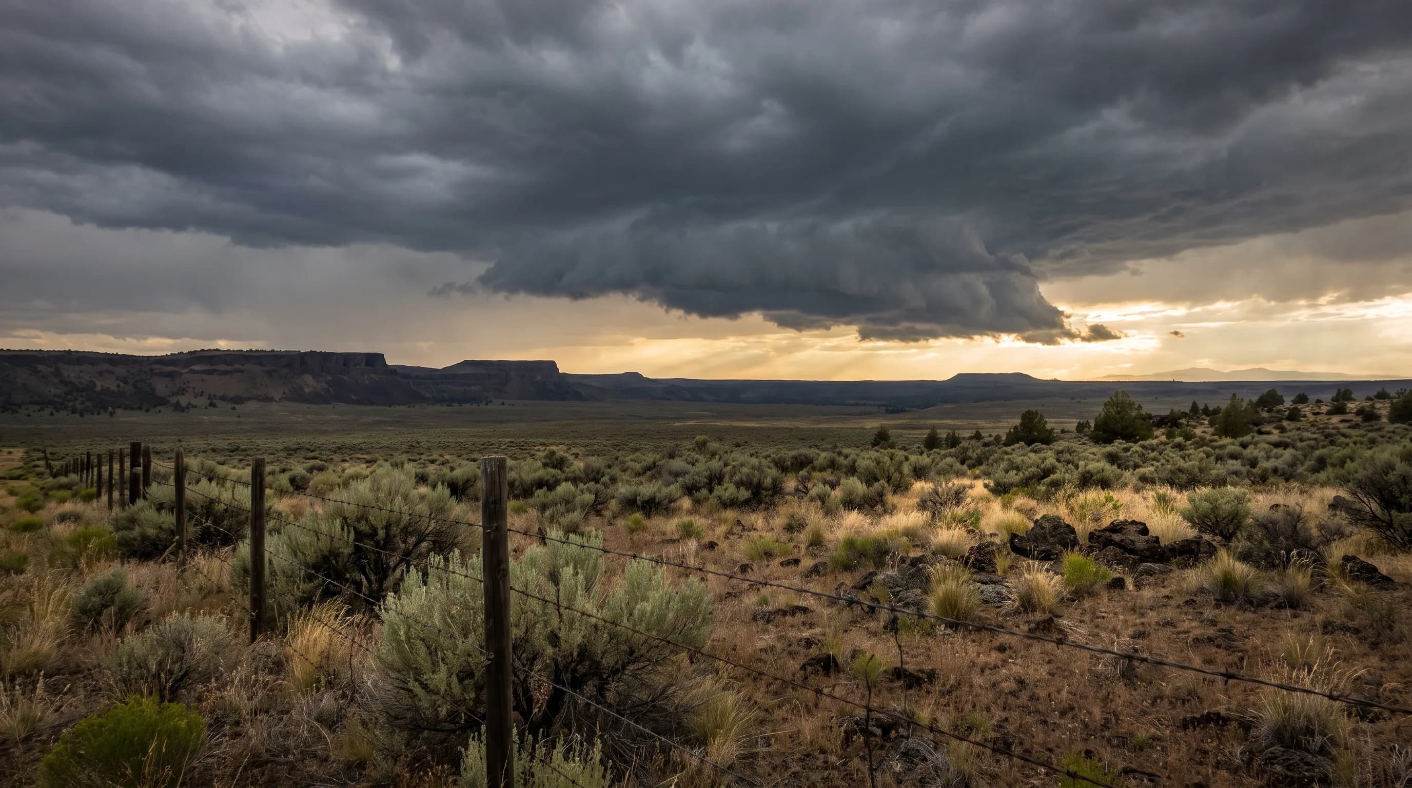
Yes, Oregon gets tornadoes, about three a year since 1995, but they are usually brief and weak: 101 of the 132 recorded from 1950 to 2024 were rated F0 or EF0. Central Oregon has recorded eight, all F0 or F1, the latest in Bend in 2017. Most of the spinning columns people see here are dust devils or fire whirls.
On April 13, 2017, a tornado touched down in Bend. Its track in the NOAA Storm Prediction Center database is 0.07 miles long, and it was rated EF0. Oregon has the ingredients for tornadoes, but only in small doses. This guide follows each ingredient to show why Oregon's tornadoes stay weak, then turns to the tornado look-alikes Central Oregon sees far more often.
Does Oregon Get Tornadoes?
Oregon does get tornadoes, though not in the numbers or strength of the Great Plains. The Storm Prediction Center's database lists 132 Oregon tornadoes from 1950 through 2024, and 88 from 1995 through 2024, about 2.9 a year. More than three-quarters were rated at the bottom of the scale.
| Rating | Oregon tornadoes | What the rating means |
|---|---|---|
| F0 / EF0 | 101 | Weakest: about 65-85 mph; broken branches, shingles lost |
| F1 / EF1 | 24 | Moderate: about 86-110 mph; roofs damaged, mobile homes pushed |
| F2 / EF2 | 4 | Considerable: about 111-135 mph; roofs torn off, large trees snapped |
| F3 | 1 | Severe: walls of well-built houses torn down |
| Unrated | 2 | Confirmed but not rated |
NOAA Storm Prediction Center tornado database, Oregon segments, 1950-2024. Ratings before February 2007 use the Fujita (F) scale; later ratings use the Enhanced Fujita (EF) scale. Wind ranges are EF-scale estimates. Central Oregon (Deschutes, Jefferson and Crook counties): eight tornadoes, all F0 or F1.
Reported tornadoes rose sharply in the 1990s, from 4 to 12 a decade before 1990 to 36 in the 1990s. Much of that rise reflects Doppler weather radar and better reporting, which caught small, brief tornadoes that would once have gone unrecorded, rather than a clear change in the weather. Why are they so weak here?
Why Are Oregon's Tornadoes Usually Weak?
Oregon's tornadoes are usually weak because the state rarely gets all three tornado ingredients at once: unstable air that rises violently, winds that turn and strengthen with height, and moist air near the ground. On the Great Plains, warm, humid air from the Gulf of Mexico often supplies all three on the same afternoon.
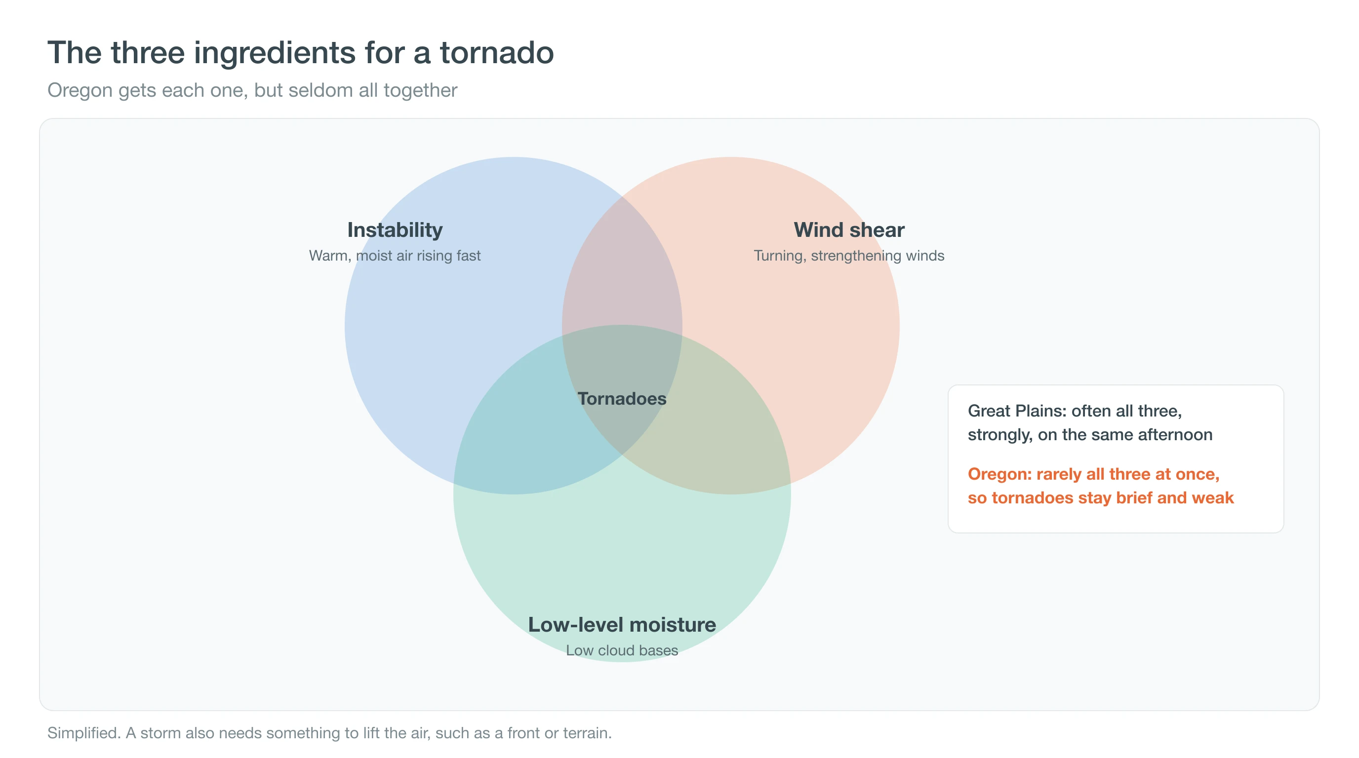
West of the Cascades, Pacific storms bring plenty of wind shear and moisture but cool air with little instability, which can produce brief, weak tornadoes in fall and winter. East of the Cascades, summer brings heat and instability but dry air and high cloud bases. The result is a state where tornadoes happen but rarely grow strong. Terrain plays a part too: the Coast Range and Cascades break up the smooth, deep flow of warm, humid air that feeds long-lived rotating storms on the open Plains, and Central Oregon's storms usually form over the mountains and buttes in the afternoon, then weaken after sunset as the ground cools. There has been one notable exception.
What Is the Strongest Tornado in Oregon History?
The only F3 in Oregon's record struck on April 5, 1972, during an unusually intense squall line. It touched down near Portland, crossed the Columbia River and did most of its damage in Vancouver, Washington, where it destroyed Peter S. Ogden Elementary School, a bowling alley and a store. Six people were killed and about 300 injured, nearly all on the Washington side.
Oregon's four F2 or EF2 tornadoes include two that many residents remember: the Aumsville tornado of December 14, 2010, in Marion County, and the Manzanita tornado on the north coast on October 14, 2016. For the state's heat, cold and snow extremes, see Oregon's weather records. And on this side of the Cascades?
Has a Tornado Ever Hit Central Oregon?
Yes, but rarely and weakly. The Storm Prediction Center lists eight tornadoes in Deschutes and Jefferson counties from 1950 to 2024, and none in Crook County. All were rated F0 or F1, none caused injuries, and the longest track was 2 miles.
| Date | County | Rating | Track length |
|---|---|---|---|
| June 22, 1983 | Deschutes | F0 | 0.1 mi |
| August 22, 1989 | Deschutes | F1 | 1.0 mi |
| July 16, 1993 | Jefferson | F0 | 0.5 mi |
| September 3, 1997 | Deschutes | F0 | 1.0 mi |
| May 23, 2001 | Deschutes | F0 | 1.0 mi |
| September 25, 2001 | Deschutes | F0 | 2.0 mi |
| June 9, 2004 | Jefferson | F0 | 0.5 mi |
| April 13, 2017 | Deschutes (Bend) | EF0 | 0.07 mi |
NOAA Storm Prediction Center tornado database.
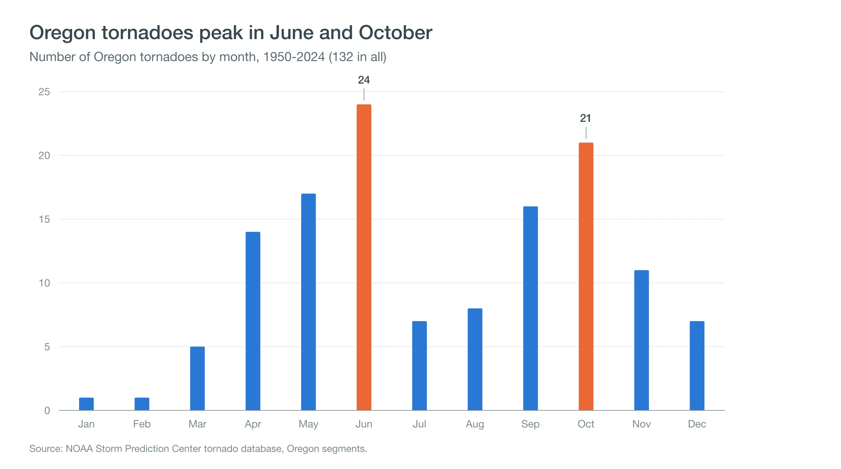
Statewide, tornadoes peak in June, with 24 in the record, and again in October, with 21. Central Oregon's came in the warm season, from April to September, mostly from the same afternoon storms that bring lightning and microbursts. Our guide to sudden summer thunderstorms explains how they build. Most spinning columns seen here are something else.
Was That a Tornado or a Dust Devil?
If the sky above it was clear or fair, it was almost certainly a dust devil. A tornado hangs from a thunderstorm cloud and is connected to it; a dust devil rises from hot ground on a sunny, calm afternoon with no storm overhead, and it is usually much weaker and shorter-lived.
- Dust devils: whirling columns of dust on hot, sunny days, common over fields and dry lots around Redmond, Madras and Prineville.
- Fire whirls: spinning columns of flame and smoke on wildfires. Large fires can build their own storm clouds; the National Weather Service in Medford confirmed a fire-generated tornado on the Bootleg Fire on July 18, 2021.
- Gustnadoes: brief whirls of dust along a storm's gust front, not connected to the cloud above.
- Scud and wall clouds: ragged low clouds can look like funnels; only rotation reaching the ground makes a tornado.
Microbursts, sudden downward blasts of wind, are a far more familiar storm hazard in Central Oregon than tornadoes. See microbursts, mammatus clouds, green storm skies and heat lightning. If a warning is issued, act on it anyway.
What Should You Do During a Tornado Warning in Oregon?
A tornado warning means a tornado has been seen or indicated by radar, so take shelter right away. The National Weather Service advises going to the lowest floor of a sturdy building, into an interior room away from windows, and covering your head. A tornado watch is different: it means conditions could produce tornadoes, so stay alert.
Warnings for Central Oregon come from the National Weather Service office in Pendleton and reach phones through Wireless Emergency Alerts and NOAA Weather Radio. Sign up for your county's emergency alerts as well, and read our storm safety guide for outdoor plans.
Deep Dive: What Do Forecasters Measure Before a Tornado?
Forecasters measure each tornado ingredient with a number: CAPE for instability, helicity for rotating winds and the lifting condensation level for low-level moisture.
What Is CAPE?
Convective available potential energy, or CAPE, measures how strongly a rising parcel of air would accelerate upward, in joules per kilogram. It grows when the air near the ground is warm and humid and the air aloft is cold. Plains tornado outbreaks often occur with CAPE in the thousands of joules per kilogram. Oregon's cool, maritime air west of the Cascades usually offers far less, and Central Oregon's summer instability comes with dry air that limits it.
What Is Wind Shear and Storm-Relative Helicity?
Tornado-producing supercell thunderstorms need winds that change speed and direction with height. That shear tilts horizontal spin into the storm's updraft and makes it rotate. Storm-relative helicity measures how much of that spin is available to a moving storm, usually in the lowest 1 to 3 kilometers. Oregon's fall and winter storms can carry strong shear with little instability, which is one reason the state's tornado record has an October peak and why those tornadoes are usually brief and weak.
Oregon's record shows the cool-season version. Of the state's 132 tornadoes from 1950 to 2024, 32 came in October and November, when Pacific storms bring strong winds aloft but little heat. The strongest recent examples fit the pattern: the Aumsville EF2 struck on December 14, 2010, and the Manzanita EF2 on October 14, 2016, both with cool-season Pacific storms rather than summer heat.
Why Does Moisture Near the Ground Matter?
The lifting condensation level is the height at which rising air cools enough to form cloud. When it is low, as in humid air, a storm's cold outflow is weaker and its rotation can reach the ground. Central Oregon's dry air often puts cloud bases a mile or more above the ground. Rain falling through that dry air evaporates and chills it, sending down gusty microbursts and dust rather than tornadoes.
A rough rule puts numbers on it: the cloud base sits about 125 meters, roughly 400 feet, higher for every degree Celsius between the temperature and the dew point. On a hot Central Oregon afternoon with a temperature of 85°F and a dew point of 35°F, a spread of about 28°C, that puts cloud bases around 11,000 feet above the ground. On a humid Plains afternoon, the spread may be only 5 to 10°C, putting bases within a few thousand feet of the surface.
What Does Oregon's Tornado Record Mean for You?
Oregon gets tornado ingredients in small doses, so its tornadoes are small, but warnings are real and deserve action. Watch storm cells on the CentralOregonWeather map with radar on, check the Bend forecast on stormy afternoons, and follow the National Weather Service in Pendleton for Central Oregon warnings.