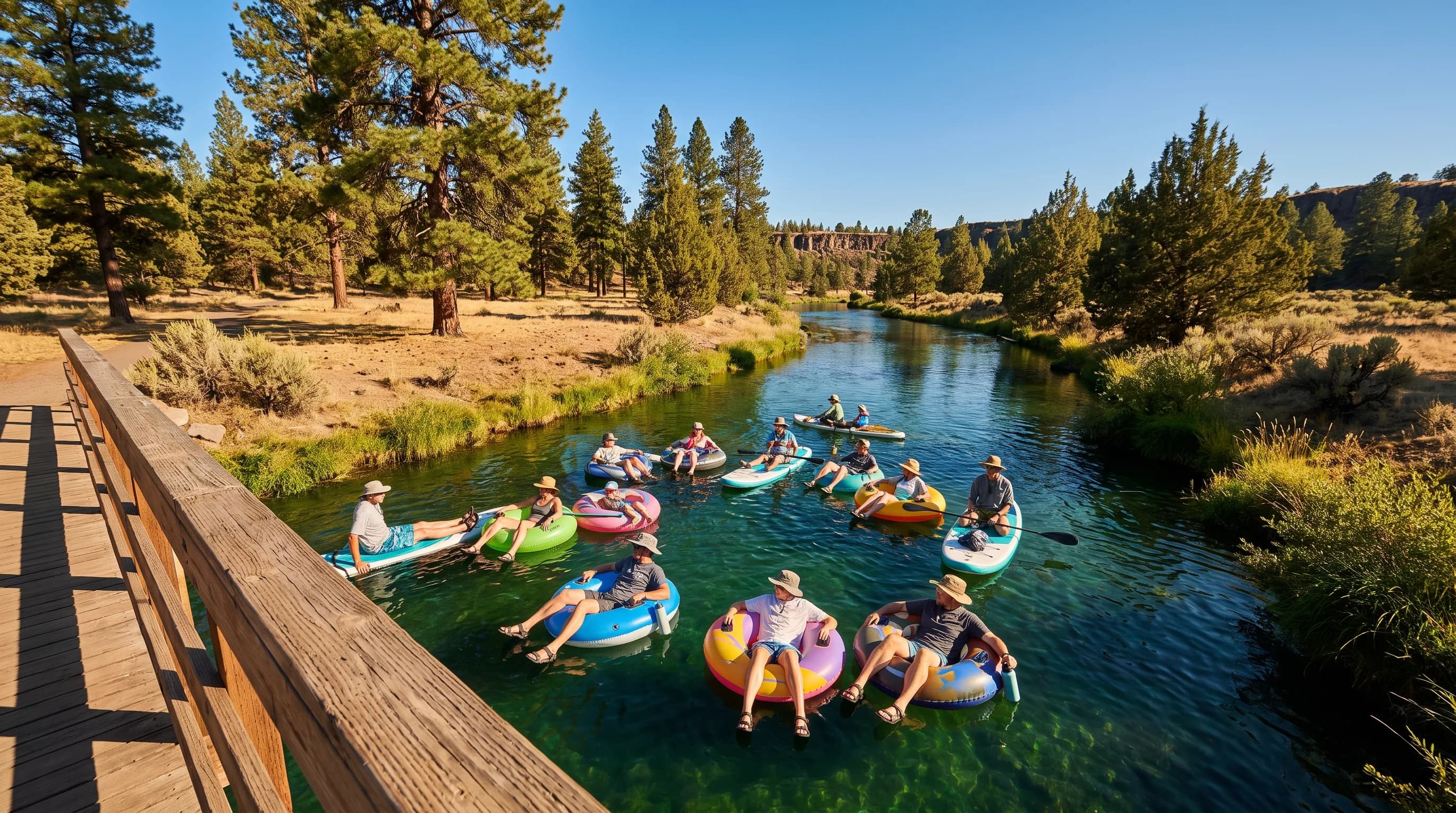
The best time to float the Deschutes in Bend is July and August, when the river runs high from reservoir releases and Bend averages more than 20 days of 80°F weather a month. The usual float from the Old Mill District to Drake Park takes about an hour to an hour and a half. Smoke and afternoon storms are the main summer spoilers, and the water stays cold.
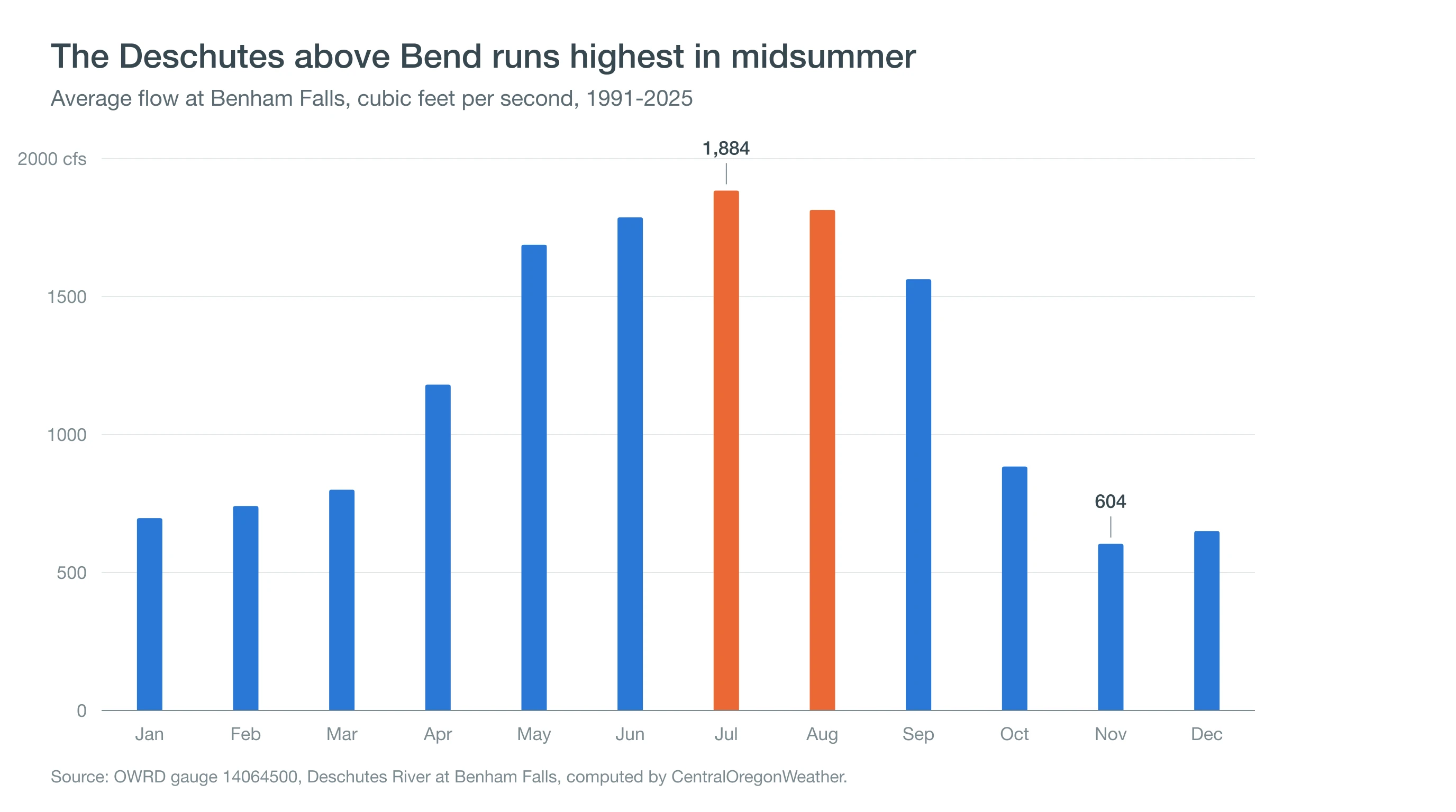
The Deschutes through Bend runs backward from what visitors expect: it is highest in midsummer, not spring. In July the river above Bend averages about 1,880 cubic feet per second (cfs), but below Bend's irrigation canals it averages about 110. Bend's float season is built on stored snow released through a dam. This guide follows that water from Wickiup Reservoir to the Bend Whitewater Park and lays the weather calendar over it, month by month.
When Is the Best Time to Float the River in Bend?
July and August line up the best river and the warmest air. June is cooler, with highs near 74°F and cold water, and September cools quickly after Labor Day. In 2026, Park & Float, where Tumalo Creek Kayak & Canoe rents gear and runs a shuttle for renters, opened June 13 and ran through Labor Day, September 7; the public Ride the River shuttle ran from June 17 to September 7.
| Month | Average high | Days 80°F+ | River at Benham Falls | Smoke days | Float season? |
|---|---|---|---|---|---|
| May | 66.3°F | 3.2 | 1,688 cfs | 0.3 | Too cool for most |
| June | 73.7°F | 7.6 | 1,787 cfs | 0.2 | Season opens mid-June |
| July | 83.8°F | 22.1 | 1,884 cfs | 1.6 | Peak |
| August | 83.3°F | 21.1 | 1,814 cfs | 5.8 | Peak; watch smoke |
| September | 75.8°F | 11.2 | 1,563 cfs | 3.3 | Ends after Labor Day |
Highs: NOAA 1991-2020 normals, Bend. Days 80°F+: computed from Bend daily records, 1991-2020. River: OWRD gauge 14064500, 1991-2025 monthly means. Smoke days: days with a smoke report at Redmond Airport, 2000-2025. Operator seasons vary by year.
The surprise in that table is the river: why is it high in August, months after the snow has melted?
Why Is the Deschutes Highest in Summer in Bend?
The Deschutes is highest in summer in Bend because Wickiup and Crane Prairie reservoirs, upstream, release stored water for irrigation from spring into fall. Wickiup alone holds about 200,000 acre-feet when full. In 2026 it held about 186,000 acre-feet on April 1 and about 25,000 on September 30; most of the difference was released downriver for irrigation.
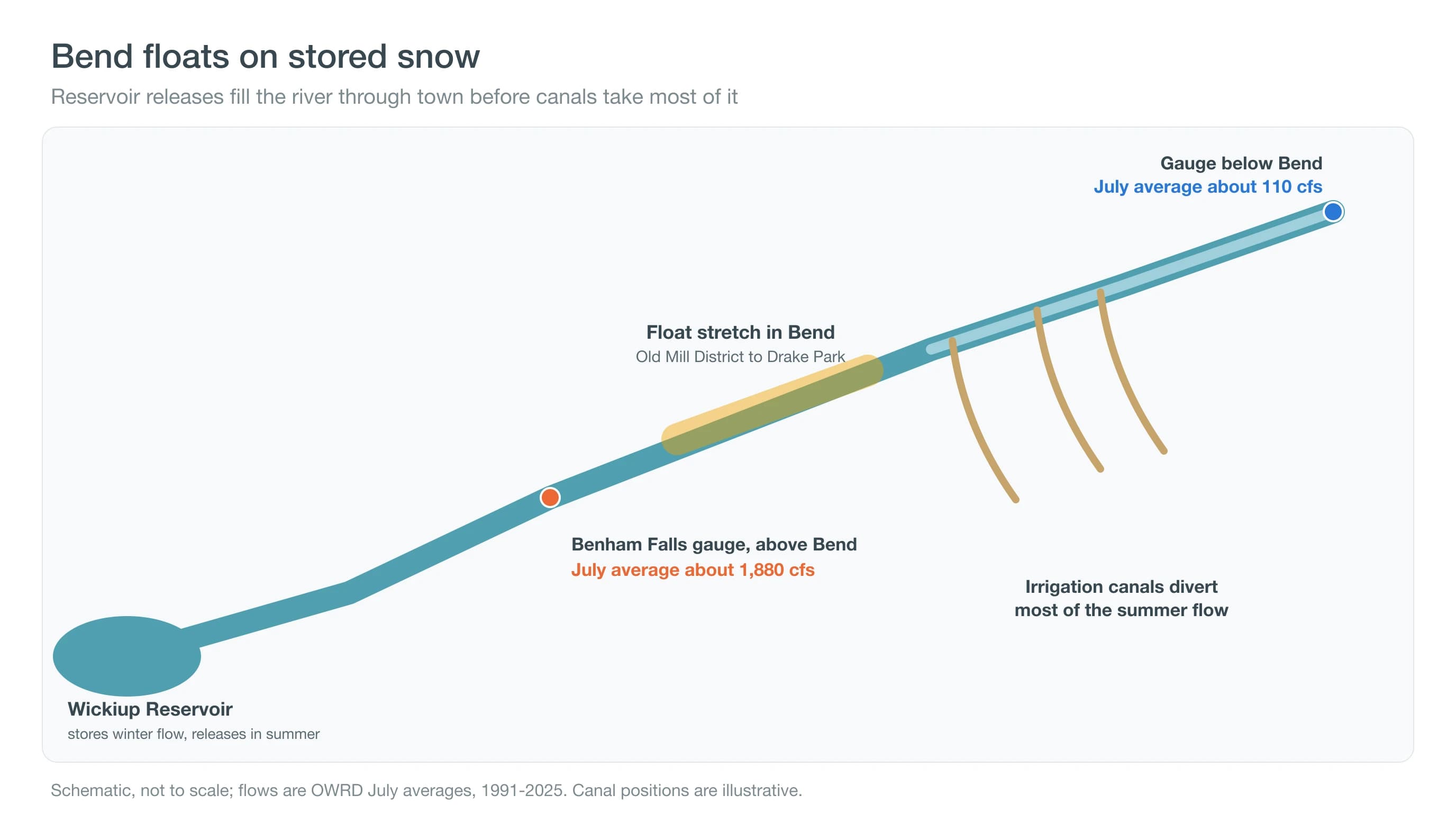
That water is headed for farms. Irrigation canals take water from the river in and around Bend, much of it at the North Canal Dam on the north side of town, downstream of the float. By the gauge below Bend, July flow averages only about 110 cfs, a small fraction of what passes Benham Falls. Our guide to snow water equivalent explains the snowpack that refills the reservoirs. High water is only half of a good float day; the air matters too.
How Hot Does Bend Get During Float Season?
Bend averages about 22 days of 80°F or warmer in July and 21 in August, and about 7 and 6 days of 90°F or hotter. Mornings stay cool, though: July lows average 48.6°F, so a float at 10 a.m. feels very different from one at 3 p.m.
Plan to float from late morning to late afternoon, when the air is warmest, and bring a dry layer for the walk back. See Bend weather in July and Bend weather in August. The two things that can cancel a float are smoke and storms.
Should You Float When It Is Smoky in Bend?
Smoke is most likely in August, when Redmond Airport reported smoke on an average of 5.8 days from 2000 to 2025, and in September, at 3.3. Floating is a light, mostly sitting activity, but the walk back and any paddling add exertion.
Check the Air Quality Index before you go. When the AQI reaches unhealthy levels, health agencies advise limiting time and exertion outdoors, especially for sensitive groups; follow AirNow and Oregon Health Authority guidance. Our Central Oregon smoke forecast shows the outlook, and Bend air quality explains when smoke clears. Storms are rarer but faster.
What Happens If a Thunderstorm Builds While You Are on the River?
Afternoon thunderstorms build over the Cascades on some summer days and can drift over Bend. Redmond Airport reports a thunderstorm on or near the field on about 1 day in July and 1.6 in August, and distant lightning on several more. If you hear thunder, get off the water and away from the river, and wait 30 minutes after the last thunder before going back.
Watch the western sky on hot afternoons: towering clouds over the mountains are the warning sign. Our guides to lightning safety on lakes and rivers and heat lightning explain the risks. And then there is the river itself.
How Cold Is the Deschutes, and What About the Whitewater Park?
The Deschutes stays cold even in August, because it is fed by reservoir releases and springs. Expect a chill when you first get in, and do not stay in the water so long that you get cold. Wear a life jacket; Bend Park & Recreation recommends them for every floater.
At the Bend Whitewater Park, floaters use the passageway channel. The middle whitewater channel is for expert boaters with proper gear only, and floaters should never enter it. Follow posted signs and Bend Park & Recreation river advisories, which can close the river after storms or for high water. The Oregon State Marine Board requires a Waterway Access Permit for non-motorized craft 10 feet or longer, including kayaks, paddleboards and larger inflatables; check its rules for your craft.
Pack for the high-desert sun as well as the water. Bend sits at about 3,600 feet, and the midsummer sun burns quickly, so bring sunscreen, sunglasses and a hat that will stay on. Water shoes or sandals with straps protect feet on rocky launches, a dry bag keeps keys and phones safe, and a light layer helps on the walk back if a breeze picks up. Leave glass and loose gear at home. Our guide to Bend's UV index explains why sunburn comes so fast here.
Deep Dive: How Did Dams and Water Rights Reshape the Upper Deschutes?
Storage dams and Oregon water law turned the upper Deschutes from one of the West's steadiest rivers into a managed one that runs high in summer and low in winter.
What Was the River Like Before the Dams?
Much of the upper Deschutes is fed by springs flowing out of porous volcanic rock, which gave it a remarkably even flow through the year. Irrigation canals began drawing on the river in the early 1900s, and storage dams followed, among them Crane Prairie and, in 1949, the U.S. Bureau of Reclamation's Wickiup Dam, built to store water for the North Unit Irrigation District. With storage in place, the river's calendar was set by the irrigation season.
How Does the Irrigation Calendar Work?
Oregon water law follows prior appropriation: older water rights are filled first. Reservoirs store water from about October to April and release it from about April to October, when canals divert most of it in and around Bend. That is why July flow drops from about 1,880 cfs above Bend to about 110 below town, and why the float stretch is full while the river below the canals runs low.
A little arithmetic shows how much of the summer river is stored water. In 2026, Wickiup's storage dropped by about 161,000 acre-feet between April 1 and September 30. Spread over those six months, that equals a net outflow of roughly 440 cubic feet per second. The rest of the roughly 1,600 to 1,900 cfs passing Benham Falls in summer comes from Crane Prairie releases, springs and tributaries such as the Fall River and the Little Deschutes, which together keep the upper river high through the summer.
What Changed for Winter Flows?
Very low winter flows below Wickiup harmed habitat for the Oregon spotted frog, which the U.S. Fish and Wildlife Service listed as threatened in 2014. The Deschutes Basin Habitat Conservation Plan, approved on December 31, 2020, adjusts the timing and volume of releases and gradually raises winter flows. The river you float in July is shaped by that agreement as well as by snow.
The plan covers the storage, release and diversion of irrigation water from five major reservoirs in the basin. Its changes are phased in over years, so river flows in a given year reflect both that year's snowpack and the plan's schedule. For floaters, July and August flows past the float stretch are still set mainly by the irrigation season.
How Should You Plan Your Float Day?
Bend's float runs on stored snow and summer sun. On float day, check the AQI on the Central Oregon smoke forecast, the afternoon storm risk on the Bend destination page, conditions at Farewell Bend Park, and Bend Park & Recreation's river status.