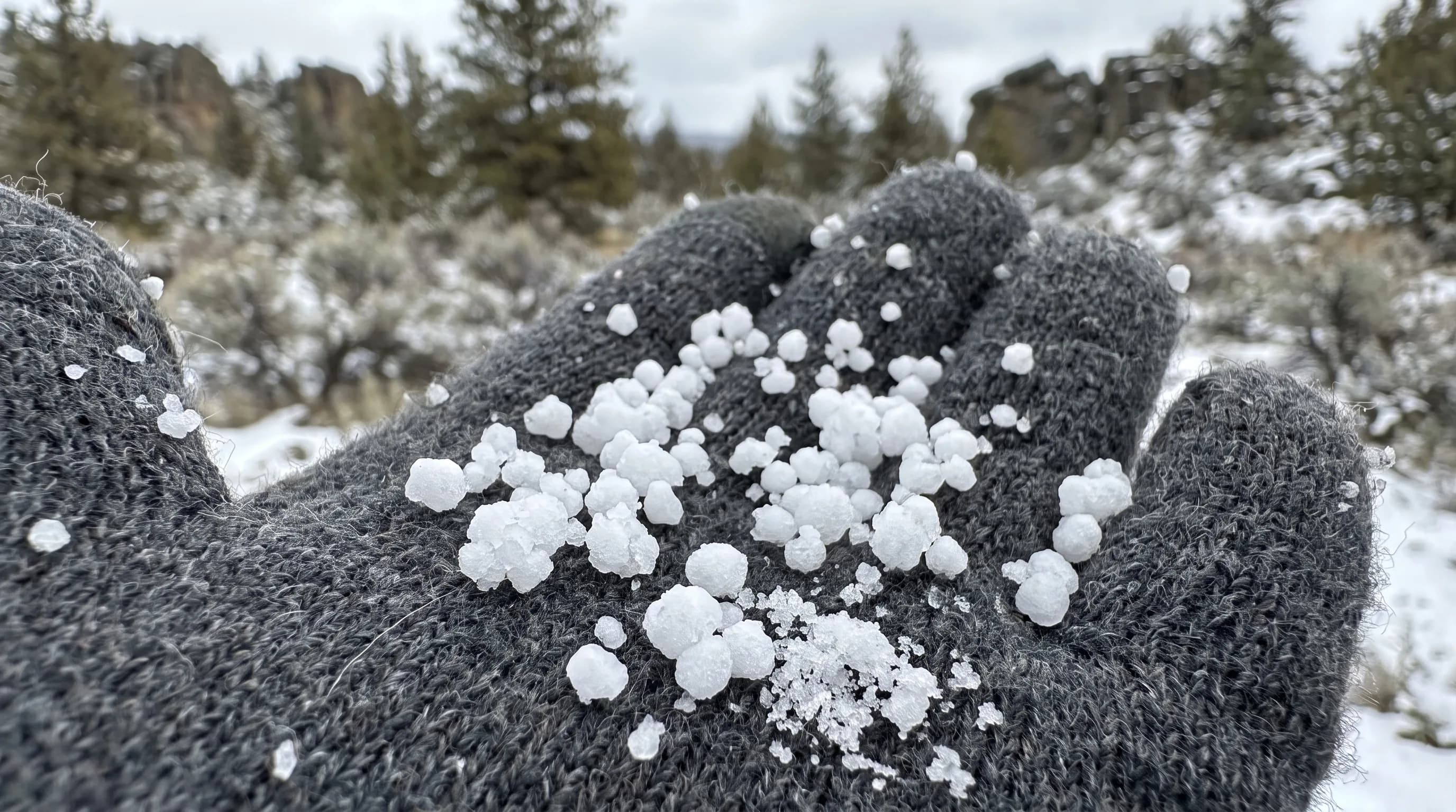
Graupel is soft, white pellets of snow, usually 2 to 5 millimeters across, that form when supercooled water droplets freeze onto a falling snowflake. It is also called snow pellets or soft hail. Graupel crumbles when squeezed, unlike hard hail or clear sleet, and in Central Oregon it falls most in showery weather from late fall through spring.
It is the Styrofoam-like pellet that bounces off car hoods in Bend during a March squall and crunches underfoot on the slopes at Mt. Bachelor. Graupel, pronounced GROU-pul (the first syllable rhymes with "how"), is a snowflake that got caught in a cloud full of supercooled water. This guide follows one snowflake through that cloud: coated in frozen droplets, falling as a soft pellet, and landing in a Central Oregon spring shower.
What Is Graupel?
Graupel is snow that has been heavily rimed, coated in tiny frozen cloud droplets until its original crystal shape is hidden. The American Meteorological Society's Glossary of Meteorology describes snow pellets as white, opaque, roughly round ice particles about 2 to 5 millimeters across that bounce and often break apart when they hit hard ground.
The word comes from German, and many people meet it first on a ski lift or on a spring walk, when what looks like hail turns out to be soft. The name sounds exotic; the process behind it is simple.
How Does Graupel Form?
Graupel forms when a snowflake falls through a cloud of supercooled droplets, water that is still liquid below 32°F. The droplets freeze the instant they touch the snowflake, a process called riming. As rime piles up, the flake's arms fill in and the crystal disappears inside a lumpy white pellet.
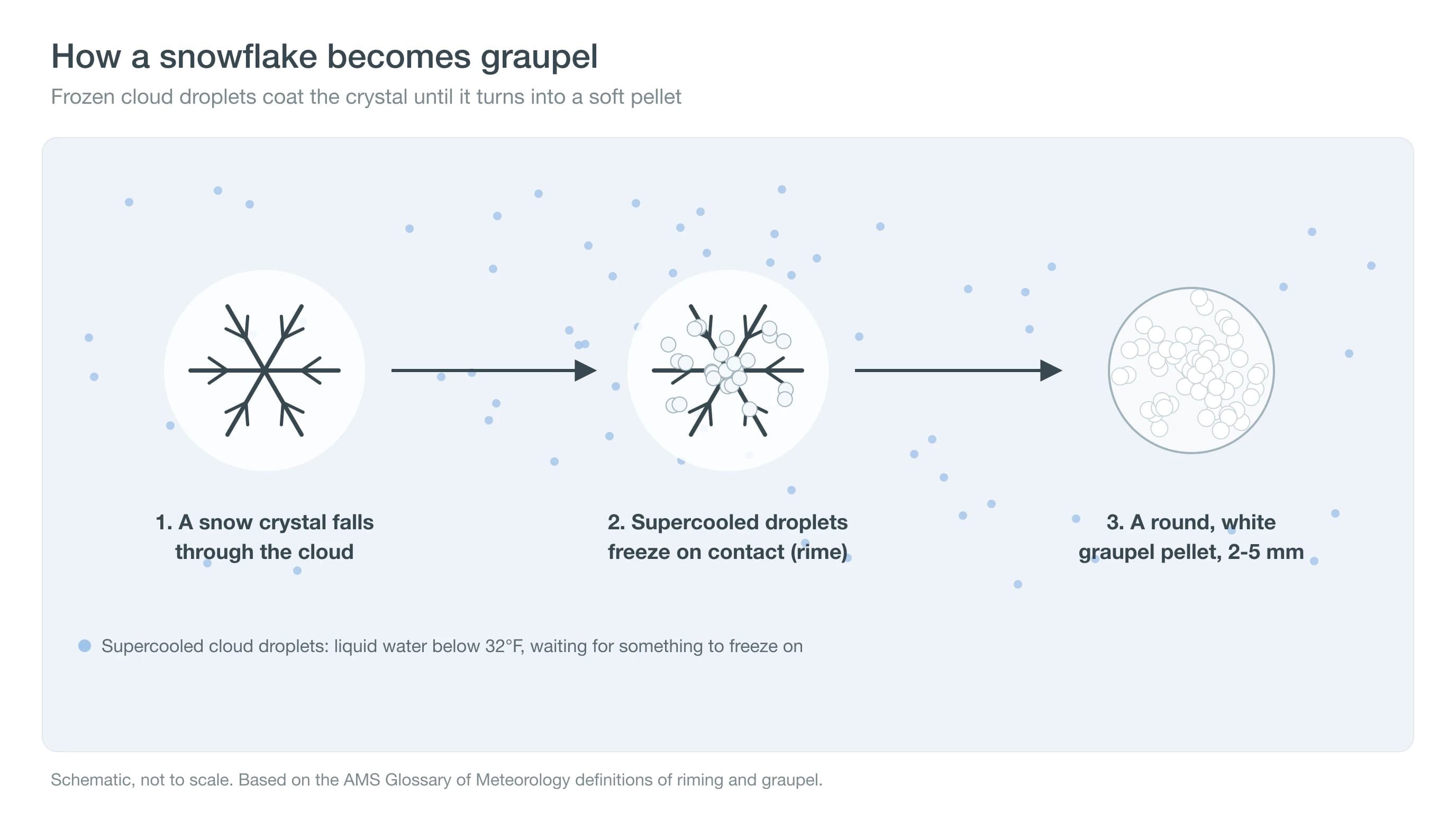
The pellet is full of tiny air pockets trapped between frozen droplets, which is why it looks bright white and feels soft. Light riming leaves a recognizable snowflake with a frosty coat; heavy riming makes graupel. The same process coats trees and fences on cold, foggy mountaintops, as our guide to rime ice explains. That process is what separates graupel from its look-alikes.
What Is the Difference Between Graupel and Hail?
Graupel is soft, white rimed snow that crumbles; hail is hard ice that grows in layers inside a thunderstorm updraft. Graupel is usually 2 to 5 millimeters across, while hail is 5 millimeters or larger and can reach golf-ball size or more in strong storms.
| Type | How it forms | Look and feel | Size | When in Central Oregon |
|---|---|---|---|---|
| Graupel | Supercooled droplets freeze onto a falling snowflake | White, opaque, soft; crumbles when squeezed | 2-5 mm | Spring and winter showers; the Cascades all winter |
| Hail | Layers of ice grow in a thunderstorm updraft | Hard, often layered, can be clear | 5 mm or more | Late spring and summer thunderstorms |
| Sleet (ice pellets) | Snow melts in a warm layer aloft, then refreezes | Clear or glassy, hard; bounces | Under 5 mm | Winter storms with a warm layer aloft |
Definitions and size thresholds follow the American Meteorological Society Glossary of Meteorology.
Hail needs a strong updraft to hold growing stones aloft, which is why it falls from thunderstorms in late spring and summer, sometimes with a greenish storm sky. Graupel needs only a showery cloud with supercooled water and snow, so it can fall from a modest squall on a cold spring afternoon. See why the sky turns green before hail. The strongest hail storms are the same kind that, very rarely, produce tornadoes in Central Oregon. The other common mix-up is sleet.
Is Graupel the Same as Sleet?
No. In the United States, sleet means ice pellets: raindrops or melted snowflakes that refreeze into clear, hard grains as they fall through a layer of below-freezing air near the ground. Graupel does not form by melting and refreezing; it is snow that grew a frozen coat inside the cloud.
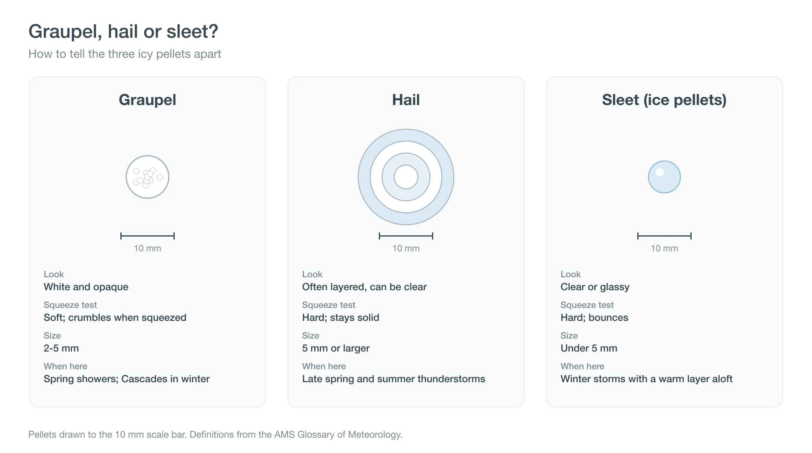
The easiest test is to pick one up. Graupel is white and squashes between your fingers; sleet is glassy and hard. Sleet falls in winter storms with a warm layer aloft, often alongside freezing rain, while graupel falls in showers. Our guide to freezing rain, sleet and snow in Central Oregon covers the warm-layer storms. Knowing what it is leads to when to expect it here.
When Does Central Oregon Get Graupel?
Central Oregon gets graupel most often in showery weather, when cold air aloft sits over ground warmed by the sun. Spring is the classic season. Bend still averages 1.5 inches of snow in March and 0.7 in April (NOAA 1991-2020), and much of it falls in quick squalls rather than steady storms, the kind of showers that produce graupel.
The rise in showery weather shows up in Redmond Airport's records. From 2000 to 2025, the airport reported lightning within about 30 miles on an average of 0.7 days in April and 3.4 days in May, as spring sun begins to drive convection. Much of that lightning is too far away to hear, the silent flicker people call heat lightning. The same cold, showery air that builds those storms also produces graupel. In the Cascades, graupel falls in winter as well, especially in showers behind cold fronts. Automated airport sensors cannot identify graupel, so there is no reliable count of graupel days; reports depend on human observers.
Skiers at Mt. Bachelor know graupel well. Showery days behind a cold front often bring bursts of pellets that pile up in small drifts and ski fast, then turn back to flakes as the shower passes. From town, graupel showers usually come from clouds with sharp, cauliflower-like tops and dark bases, separated by patches of blue sky, rather than the flat gray deck of a steady winter storm. Spring sunshine heats the ground between showers, which is why the pattern can repeat several times in one afternoon.
See Bend weather in March and snow squalls for the showery weather that brings it. Graupel is usually harmless, with two exceptions.
Is Graupel Dangerous?
Graupel is usually not dangerous; the pellets are soft and light. The first exception is traction. A burst of graupel can coat roads, sidewalks and trails with a layer of pellets that act like tiny ball bearings, making them slick for a few minutes until the pellets melt or pack down. Slow down when a squall hits.
The second exception is in the backcountry. A layer of graupel that gets buried by later snow can act as a weak layer in the snowpack, because the round pellets do not bond well to the snow above them. Avalanche professionals track these layers; before a backcountry trip, check the Central Oregon Avalanche Center forecast.
Deep Dive: How Does a Snowflake Become a Pellet, and Why Does It Matter for Lightning?
A snowflake becomes a pellet by sweeping up supercooled droplets, and the same collisions between graupel and ice crystals help charge thunderstorms with electricity.
How Do Supercooled Droplets Freeze Onto a Snowflake?
Cloud droplets can stay liquid well below 32°F because they lack a surface to start freezing on. When a falling ice crystal sweeps them up, they freeze on contact. Larger, faster-falling crystals collect droplets more efficiently, so riming speeds up once it starts: the heavier the rime, the faster the particle falls, and the more droplets it hits. The result can range from fluffy pellets that crumble at a touch to dense ones that feel almost like hail, depending on how quickly each droplet froze and how much air was trapped between them.
Heavy riming also changes how fast the particle falls. Classic measurements by Locatelli and Hobbs (1974) found that unrimed snowflakes fall at about 1 meter per second, while graupel pellets fall faster, roughly 1 to 3 meters per second depending on size and density. Faster-falling pellets sweep up droplets more quickly and spend less time drifting, which is why a graupel shower arrives as a sudden, rattling burst rather than a slow drift of flakes.
Why Does Graupel Help Make More Ice?
Between about 27°F and 18°F (-3 to -8°C), riming throws off tiny splinters of ice, a process known as Hallett-Mossop ice multiplication. Each splinter can grow into a new crystal, which can then rime into more graupel. That feedback can turn a cloud full of supercooled water into a cloud full of ice surprisingly quickly.
What Does Graupel Have to Do With Lightning?
The leading explanation for how thunderstorms build electric charge involves graupel. When graupel and small ice crystals collide in the presence of supercooled water, electric charge transfers on each bounce. Updrafts and gravity then separate the heavier graupel from the lighter crystals, building regions of opposite charge, as reviewed by Saunders (2008, Space Science Reviews). Graupel showers run the same machinery on a small scale; scaled up, it produces lightning, and in winter, even thundersnow.
Laboratory experiments, beginning with work by Tsutomu Takahashi in the 1970s, found that the sign of the charge depends on temperature and on how much supercooled water is present. In the colder upper part of a storm, graupel tends to charge negatively; in warmer, lower parts it can charge positively. That temperature dependence helps explain the layered pattern of charge inside thunderclouds, and it is one reason scientists watch graupel so closely when they study how storms become electrified.
How Can You Tell When Graupel Is Coming?
Graupel is a snowflake that met a cloud full of water, so look for showery, unsettled days with cold air aloft and snow levels near town, especially in spring. On those days, check the Central Oregon snow forecast and the Mt. Bachelor forecast, slow down when a squall hits, and check the Central Oregon Avalanche Center before backcountry trips.